1756 Bellin Map of Formosa (Taiwan)
Formose-bellin-1756$500.00

Title
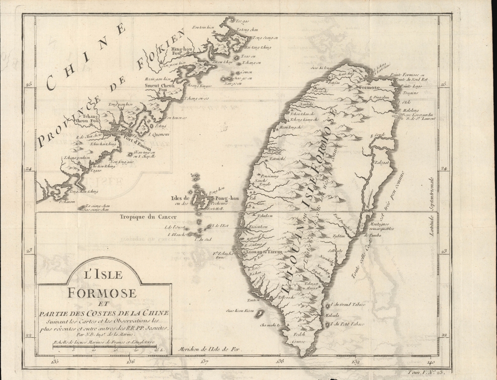
L'Isle Formose et Partie des Costes de la Chine.
1756 (undated) 9 x 11 in (22.86 x 27.94 cm) 1 : 2100000
1756 (undated) 9 x 11 in (22.86 x 27.94 cm) 1 : 2100000
Description
An important early (c. 1756) European map of Taiwan by Jacques-Nicolas Bellin, which appeared in l'Abbé Prévost's Histoire générale des voyages. Drawing on information from Jesuit missionaries, Bellin's map was among the earliest European maps to focus on the island and the first to employ its contemporary official Chinese name (Taiwan, here as 'Taiouan or Taivan').
A Closer Look
Coverage includes the island of Taiwan or Formosa, surrounding islands, and the opposite coast of Fujian. Settlements, waterways, and areas of elevation are illustrated, along with approximations of local placenames. Bellin admits that the geography of the interior and east side of the island is not well known, though the basic features are not wildly inaccurate. The island's two most notable settlements were at Tainan (here as ''Taiouan or Taivan,' as in Taiwan-fu, the administrative center established by the Qing Dynasty in 1683) and 'Formose' near today's Taipei. The ruins of Ft. Zeelandia near Tainan, Baimiweng Fort at Keelung near Taipei, and Fengguiwei Fort on Magong in the Penghus are labelled, reflecting the recent Dutch presence on Taiwan. Across the strait is Zhangzhou (Tchang Cheou Fou), Xiamen (Emoui, later rendered as Amoy), Quanzhou (Sruent Cheou Fou), and Putian (Hing Hou Fou). Nearby islands are also recorded, including the Penghus, Lanyu (I. du Petit Tabaco), and Lüdao (I. du Grand Tabaco).Publication History and Census
This map was drawn by Bellin for inclusion as Plate No. 23 in Vol. 5 of l'Abbé Prévost's Histoire générale des voyages, ou nouvelle collection de toutes les relations de voyages par mer et par terre, published between 1746 and 1759. Due to uncertainty over the map's date and the intermingling of digital and physical examples, the map appears in nine separate OCLC listings, but the number of institutions holding physical examples is limited to Cornell University, the Bibliothèque nationale de France, the Universitätsbibliothek Bern. A small number of other institutions also hold later printings (distinguishable by the volume and plate number at bottom-right), while the entire Histoire générale des voyages is more widely distributed in institutional collections.CartographerS
Jacques-Nicolas Bellin (1703 - March 21, 1772) was one of the most important cartographers of the 18th century. With a career spanning some 50 years, Bellin is best understood as geographe de cabinet and transitional mapmaker spanning the gap between 18th and early-19th century cartographic styles. His long career as Hydrographer and Ingénieur Hydrographe at the French Dépôt des cartes et plans de la Marine resulted in hundreds of high quality nautical charts of practically everywhere in the world. A true child of the Enlightenment Era, Bellin's work focuses on function and accuracy tending in the process to be less decorative than the earlier 17th and 18th century cartographic work. Unlike many of his contemporaries, Bellin was always careful to cite his references and his scholarly corpus consists of over 1400 articles on geography prepared for Diderot's Encyclopedie. Bellin, despite his extraordinary success, may not have enjoyed his work, which is described as "long, unpleasant, and hard." In addition to numerous maps and charts published during his lifetime, many of Bellin's maps were updated (or not) and published posthumously. He was succeeded as Ingénieur Hydrographe by his student, also a prolific and influential cartographer, Rigobert Bonne. More by this mapmaker...
Antoine François Prévost d'Exiles (April 1, 1697 – November 25, 1763), usually known the Abbé Prévost, was a French author and novelist. Having had difficulty in his youth determining a preference for life in the military or life among the Jesuits, he eventually wound up with the Benedictines, with whom he took vows. Despite his taking the vows, the vows evidently did not take with him: in 1728 he abandoned his abbey and fled to London. Naturally, he became a writer. In this he was prolific, both producing his own work and translations of others. Beginning in 1726, he published the first volume of his Histoire générale des voyages, which he worked on for the remained of his life and which was completed by his associates after his death, stretching to 25 volumes. Learn More...
Source
Prevost, Histoire générale des voyages, ou nouvelle collection de toutes les relations de voyages par mer et par terre (Paris: Didot, 1746 - 1759).
Condition
Very good. Some offsetting, else excellent with full margins and a bold strike.
References
OCLC 63835772, 495096044, 1331973447.