1829 Lapie Map of France in Military Departments and Divisions
FranceDepartments-lapie-1829$150.00

Title
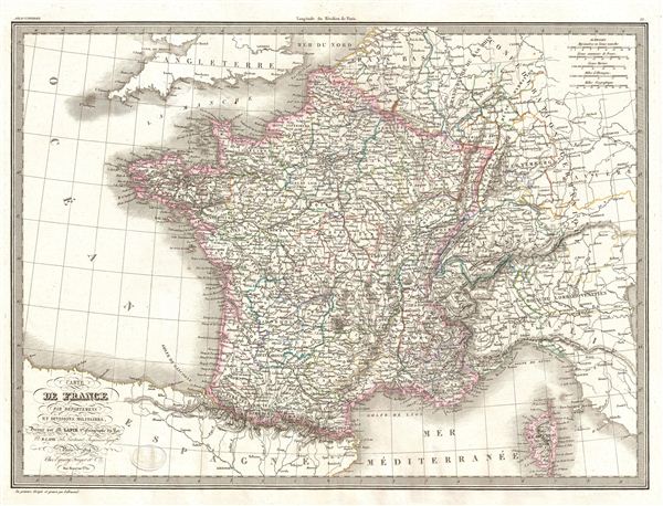
Carte de France par departemens et divisions militaires.
1829 (dated) 16.25 x 22 in (41.275 x 55.88 cm)
1829 (dated) 16.25 x 22 in (41.275 x 55.88 cm)
Description
A fine first edition example of M. Lapie's 1829 Map of France by Military Departments and Divisions. Centered on France, the map includes parts of adjacent Spain, england, Switzerland, Italy and Germany. Lapie's map offers fine detail throughout with elevation rendered by hachure and political boundaries demarcated with outline hand color. This map of France was issued in the first days of the July Monarchy, a liberal constitutional monarchy under King Louis-Philippe. The July Monarchy would last until the Revolution of 1848 which saw the establishment of the Second Republic.
This map was engraved by Armand Joseph Lallemand as plate no. 22 in the first edition of M. Lapie's important Atlas Universel. This map, like all maps from the Atlas Universel features an embossed stamp from the Lapie firm.
This map was engraved by Armand Joseph Lallemand as plate no. 22 in the first edition of M. Lapie's important Atlas Universel. This map, like all maps from the Atlas Universel features an embossed stamp from the Lapie firm.
CartographerS
Pierre M. Lapie (fl. 1779 - 1850) and his son Alexandre Emile Lapie (fl. 1809 - 1850) were French cartographers and engravers active in the early part of the 19th century. The Lapies were commissioned officers in the French army holding the ranks of Colonel and Capitan, respectively. Alexander enjoyed the title of "First Geographer to the King", and this title appears on several of his atlases. Both father and son were exceptional engravers and fastidious cartographers. Working separately and jointly they published four important atlases, an 1811 Atlas of the French Empire (Alexander), the 1812 Atlas Classique et Universel (Pierre), the Atlas Universel de Geographie Ancienne et Modern (joint issue), and the 1848 Atlas Militaire (Alexander). They also issued many smaller maps and independent issues. All of these are products of exceptional beauty and detail. Despite producing many beautiful maps and atlases, the work of the Lapie family remains largely underappreciated by most modern collectors and map historians. The later 19th century cartographer A. H. Dufour claimed to be a student of Lapie, though it is unclear if he was referring to the father or the son. The work of the Lapie firm, with its precise engraving and informational density, strongly influenced the mid-19th century German commercial map publishers whose maps would eventually dominate the continental market. More by this mapmaker...
Armand Joseph Lallemand (c. 1810 - 1871) was an engraver and map publisher based in Paris during the mid-19th century. Most of Lallemand's work focused on landscapes and building vies, though he did take part in a few cartographic ventures, including the production of an atlas with Alexandre Emile Lapie and several tourist pocket maps of Paris. Learn More...
Source
Lapie, M., Atlas Universel de Geographie. Ancienne et Moderne, precede d'un Abrege de Geographic Physique et Historique…, 1829. (Rumsey identifies this as the first edition of Lapie's Atlas Universel. In all known examples, the title page is dated 1829 while the maps are dated variously to 1833 - suggesting that the first issue of this atlas was 1833, not 1829.)
Condition
Very good. Original platemark visible. Blank on verso. Original centerfold.
References
Rumsey 2174.022. Phillips (Atlases) 754, 765.