Digital Image: 1954 Burgess Comic Pictorial Map of Frankfurt, Germany
Frankfurt-burgess-1954_d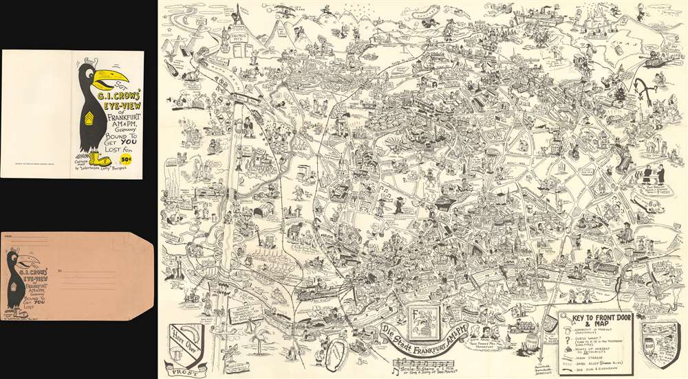

Title
Sgt. G.I. Crows' Eye View of Frankfurt AM and PM, Germany. Bound to Get You Lost for 50 cents.
1954 (dated) 23.25 x 33 in (59.055 x 83.82 cm)
1954 (dated) 23.25 x 33 in (59.055 x 83.82 cm)
Description
FOR THE ORIGINAL ANTIQUE MAP, WITH HISTORICAL ANALYSIS, CLICK HERE.
Digital Map Information
Geographicus maintains an archive of high-resolution rare map scans. We scan our maps at 300 DPI or higher, with newer images being 600 DPI, (either TIFF or JPEG, depending on when the scan was done) which is most cases in suitable for enlargement and printing.
Delivery
Once you purchase our digital scan service, you will receive a download link via email - usually within seconds. Digital orders are delivered as ZIP files, an industry standard file compression protocol that any computer should be able to unpack. Some of our files are very large, and can take some time to download. Most files are saved into your computer's 'Downloads' folder. All delivery is electronic. No physical product is shipped.
Credit and Scope of Use
You can use your digial image any way you want! Our digital images are unrestricted by copyright and can be used, modified, and published freely. The textual description that accompanies the original antique map is not included in the sale of digital images and remains protected by copyright. That said, we put significant care and effort into scanning and editing these maps, and we’d appreciate a credit when possible. Should you wish to credit us, please use the following credit line:
Courtesy of Geographicus Rare Antique Maps (https://www.geographicus.com).
How Large Can I Print?
In general, at 300 DPI, you should at least be able to double the size of the actual image, more so with our 600 DPI images. So, if the original was 10 x 12 inches, you can print at 20 x 24 inches, without quality loss. If your display requirements can accommodate some loss in image quality, you can make it even larger. That being said, no quality of scan will allow you to blow up at 10 x 12 inch map to wall size without significant quality loss. For more information, it is best consult a printer or reprographics specialist.
Refunds
If the high resolution image you ordered is unavailable, we will fully refund your purchase. Otherwise, digital images scans are a service, not a tangible product, and cannot be returned or refunded once the download link is used.
Cartographer
Byrel William Burgess (April 5, 1914 - March 21, 1983), also known as 'Lefty' and 'Sgt. Crow' was an American career military engineer, as well as a comic and illustrator. Burgess was born in Owosso, Michigan. In 1938 he was living in Flint, Michigan, where he married Evelyn Anderson and worked as a sign painter for the Works Progress Administration (WPA). He may have had as much as 1 years of college before entering the military. There is a great deal of confusion regarding the dates of his military service, as he seems to have repeatedly entered and left the army, but in general, he was consistently in the U.S. Army Engineering Corps from 1941 to 1962 and attained the rank of Master Sargent. In 1943, he was called to active service to fight World War II (1939 - 1945). He served in Burma and China under General 'Vinegar Joe' Stilwell (1883 - 1946). During his service, he may have met and been inspired by fellow pictorial mapmaker Frank Dorn (1901 - 1981), who also served under Stilwell. His first map, made around 1945, illustrated the city of Chongqing, China, where he was stationed on a covert base at the end of World War II. After the war, he was transferred to London, issuing a pictorial map of that city in 1951. Then to Frankfurt, where he issued his most popular and common map, the 1954 Sgt. G.I. Crows' Eye View of Frankfurt AM and PM, Germany. It is not clear if Burgess served in the Korean War (1950 - 1953), but he was in Seoul in 1957, when he he issued Sgt. Papasan Lefty's Map and Cartoon of the City of Seoul, with a Korean publisher. Around 1960, Burgess was in San Francisco, where in October, he filed copyrights for two maps, A Crow's Eye View of Fisherman's Wharf, Telegraph Hill and part of the Embarcadero and Nite Owl's Map of Chinatown and Nite Club Land. These may never have been published as there are no known examples. Burgess then relocated to San Leandro, where he contributed cartoons to Oak Leaf, the in-house publication of the Naval Regional Medical Center of Oakland. He then lived in Yountville, Napa. He was buried in the San Francisco National Cemetery. Of his several maps, only the map of Frankfurt is obtainable. His map of Seoul is known in only 2 surviving examples. His other work is known only from secondary sources, such as copyright filings and articles. As a pictorial cartographer, his work is significant and unique in capturing U.S. foreign military life at ephemeral historical moments. More by this mapmaker...
References
OCLC 59284292.