This item has been sold, but you can get on the Waitlist to be notified if another example becomes available, or purchase a digital scan.
1827 Vandermaelen map of the Straits of the Galapagos Islands, Ecuador
Galapagos-vandermaelen-1827$350.00

Title
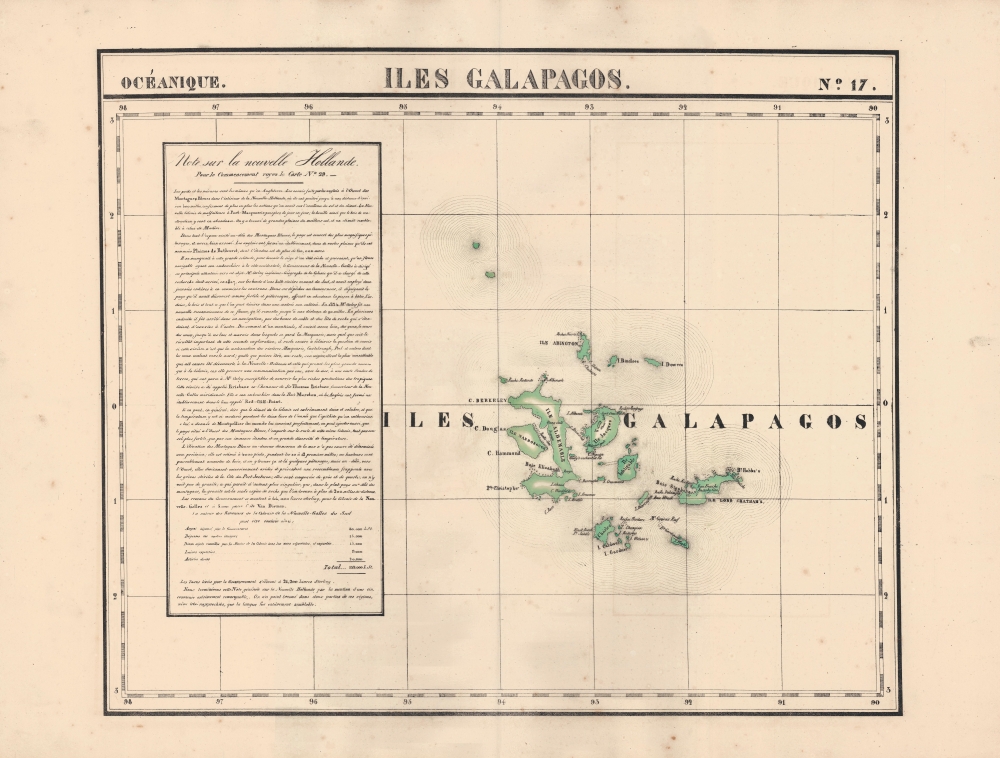
Iles Galapagos. Oceanique no. 17.
1827 (undated) 18.5 x 22 in (46.99 x 55.88 cm) 1 : 1641836
1827 (undated) 18.5 x 22 in (46.99 x 55.88 cm) 1 : 1641836
Description
An 1827 Phillipe Vandermaelen map of the Galapagos Islands, considered the earliest lithographed map of those islands. Vandermaelen's Atlas Universel was the first lithograph atlas as well as the first whose maps were printed on a universal scale.
Simultaneously, Spain's colonial empire in the Americas was disintegrating, leading to the independence of Gran Colombia in 1822, from which Ecuador seceded in 1830. Gen. José de Villamil, founder of the Ecuadorian Navy, recognized that the islands were vulnerable to European colonization and quickly moved to settle them, mostly with prisoners, naming the new settlement on Charles / Floreana Island Asilo de Paz (Haven of Peace). Villamil was appointed governor and the colony saw some success, but over time proved untenable, with settlers clamoring to return to the mainland.
Villamil resigned in 1837 and was replaced by his lieutenant, Nicholas Lawson, whereupon a new colony was established on Indefatigable / Santa Cruz Island. Seven years later, Lawson met members of the British FitzRoy Expedition, including Charles Darwin, during the Second Voyage of the HMS Beagle. Lawson's descriptions of the differences in sea tortoises originating on different islands in the archipelago were important in leading Darwin to consider their divergent evolutionary paths.
A Closer Look
The Galapagos archipelago is detailed in hand-colored outline. Vandermaelen employs English names, derived ultimately from Cowley's 1684 map of the islands, rather than the developing Spanish nomenclature. Aside from islands themselves, capes, bays, hazards, reefs, rocks, shoals, and the location of fresh water are noted.Australia?
The text at left relates to Australia (New Holland). This appears strange at first glance given the distance between the Galapagos and Australia, and the variance in the numbering of sheets in the series, but makes sense when one considers the intended orientation of the maps. Vandermaelen, a globe-maker by training, designed the atlas so the maps could be laid out next to each other, as on a globe. The high level of interest in Australia given the relatively recent discoveries made by Cook and others, as well as the establishment of a British colony there, demanded more information than could fit on the Australia sheets, and the text provided here is a continuation of that in map No. 29 in the series, already dominated by a large text box.A Hive of Activity
A decade before this map's publication, the Galapagos Islands were hardly noticed. Occasional explorers had sailed past the islands, while pirates used it as a hideout, but this relatively unimportant status changed dramatically after 1820, when a Nantucket whaling ship reported numerous whales in the nearby waters. Soon, whaling ships and tortoise hunters swarmed the islands.Simultaneously, Spain's colonial empire in the Americas was disintegrating, leading to the independence of Gran Colombia in 1822, from which Ecuador seceded in 1830. Gen. José de Villamil, founder of the Ecuadorian Navy, recognized that the islands were vulnerable to European colonization and quickly moved to settle them, mostly with prisoners, naming the new settlement on Charles / Floreana Island Asilo de Paz (Haven of Peace). Villamil was appointed governor and the colony saw some success, but over time proved untenable, with settlers clamoring to return to the mainland.
Villamil resigned in 1837 and was replaced by his lieutenant, Nicholas Lawson, whereupon a new colony was established on Indefatigable / Santa Cruz Island. Seven years later, Lawson met members of the British FitzRoy Expedition, including Charles Darwin, during the Second Voyage of the HMS Beagle. Lawson's descriptions of the differences in sea tortoises originating on different islands in the archipelago were important in leading Darwin to consider their divergent evolutionary paths.
Publication History and Census
This map appeared in the sixth part, 'Océanique,' of Vandermaelen's Atlas universel de géographie physique, politique, statistique et minéralogique. The atlas was produced in one edition in 1827; only 810 complete sets were sold. The full set of six volumes appears in eleven institutional collections in OCLC, and the 6th volume alone is listed in 10, but the map is not independently cataloged.Cartographer
Philippe Marie Guillaume Vandermaelen (December 23, 1795 - May 29, 1869) was a Flemish cartographer active in Brussels during the first part of the 19th century. Vandermaelen is created with "one of the most remarkable developments of private enterprise in cartography," namely his remarkable six volume Atlas Universel de Geographie. Vandermaelen was born in Brussels in 1795 and trained as a globe maker. It was no doubt his training as a globe maker that led him see the need for an atlas rendered on a universal scale in order that all bodies could be understood in relation to one another. In addition to his great work Vandermaelen also produced a number of globes, lesser maps, a highly detailed 250 sheet map of Belgium, and several regional atlases. More by this mapmaker...
Source
Vandermaelen, P., Atlas universel de geographie physique, politique, statistique et mineralogique, (Bruxelles: Vandermaelen) 1827.
Atlas Universel de Geographie. This great work, featuring some 378 unique maps and compiled over three years, was the first lithograph atlas, and the first to render the world on the same projection and at a uniform scale. It was no doubt Vandermaelen’s training a globe maker that led him see the need for an atlas rendered uniformly so that all bodies could be understood in relation to one another. As a result, many newly emerging areas received more attention than prior efforts. Maps of the American West, in particular, benefited: ‘no mapmaker had previously attempted to use such a large scale for any western American area.’ (Wheat). Central and South Asia also appear in sharper focus. Despite Vandermaelen’s reliance upon existing sources, his maps very frequently provided the clearest depictions available of many poorly-understood parts of the world. The atlas was an expensive production, costing $800 in 1827. Subscription lists indicate that only 810 full sets of the atlas were sold. It was printed on high-quality paper with superior hand coloring and was engraved in a clear, legible style. Conjoined, the maps of Vendermaelen's atlas would create a massive globe some 7.75 meters in diameter, a feat which was accomplished at the Etablissement Geographique de Brussels.
Condition
Very good. Minor foxing throughout.
References
Rumsey 2212.345.