This item has been sold, but you can get on the Waitlist to be notified if another example becomes available, or purchase a digital scan.
1874 Tardieu Map of Gaul or France in 507, 816, 987 and 1677
Gauleen507-tardieu-1874$50.00

Title
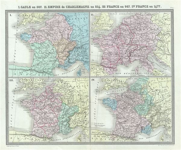
I. Gaule en 507. II. Empire de Charlemagne en 814. III. France en 987. IV. France en 1677.
1874 (undated) 15 x 17 in (38.1 x 43.18 cm) 1 : 7200000
1874 (undated) 15 x 17 in (38.1 x 43.18 cm) 1 : 7200000
Description
This is a fine 1874 map of Gaul or France by Ambroise Tardieu. Essentially four maps on a single sheet, it depicts Gaul or France during 507, 816, 987 and 1677. The first map, Gaul in 507 depicts the region from divided into territories of the Kingdom of the Wisigoths, Franks, Burgonde and Ostrogoths. The important Battle of Vouille between the Frankish King Clovis and Alaric II, the King of the Visigoths took place in 507 CE. It is arguably the turning point for France, when, with the defeat of the Visigoths, Gaul was left largely to the Franks, becoming Francia and when 'France began.'
The second map depicts the Empire of Charlemagne. After ruling and reforming France in 768, Charlemagne conquered Italy and, in 800, was crowned Holy Roman Emperor. For the next 14 years until his death, Charlemagne's Empire united much of Western and Central Europe for the first time since the collapse of the Roman Empire. The 'Carolingian Renaissance' witnessed a Catholic themed revival of art, religion, and culture, encouraging the formation of a common European identity.
The third map in the bottom left quadrant depicts France in 987. France was then under Hugues Capet or Hugh the Great, c. 987-997. The last map in the bottom right quadrant depicts France in 1677 under the expansionist Sun King of France, Louis XIV.
This map was prepared by Ambroise Tardieu and issued as plate 10 in his 1874 edition of Atlas Universel de Geographie Ancienne et Moderne.
CartographerS
Ambroise Tardieu (March 2, 1788 - January 17, 1841) was a prominent French cartographer and engraver operating in the late 18th and early 19th centuries. He was member of the large and prolific Tardieu family, which, for over 200 years, produced multiple skilled and active engravers. Tardieu's work is known for its beauty and accuracy as well as for its depth of detail. Tardieu's most important work is his version of John Arrowsmith's large format map of the United States, published in 1806. Ambroise Tardieu is eclipsed in fame by his son, artist and medical scholar, August Ambroise Tardieu. Ambroise Tardieu is also frequently confused with Jean Baptiste Pierre Tardieu, another unrelated French map and print engraver active in the early 19th century. More by this mapmaker...
Alexandre Aimé Vuillemin (1812 - 1880) was an engraver, publisher, and editor based in Paris, France in the middle of the 19th century. Despite a prolific publishing career, much of Vuillemin's life is shrouded in mystery. In 1852, he married Josephine Caroline Goret and they had at least one child, Ernestine Adèle Vuillemin, later in the same year. What is known is that his studied under the prominent French Auguste Henri Dufour (1798 - 1865). Vuillemin's most important work his detailed, highly decorative large format Atlas Illustre de Geographie Commerciale et Industrielle. Learn More...
Source
Furne, Jouvet et Cie Atlas Universel de Geographie Ancienne et Moderne (Paris), 1874.
Condition
Very good. Minor wear along original centerfold. Original platemark visible. Minor spotting.
References
Rumsey 4697.014 (1863 edition).