1595 Ortelius Map of Gelderland, the Netherlands
Geldria-ortelius-1595$450.00


Title
Gelriae, Cliviae, Finitimorumque Locorum Verissima Descriptio.
1595 (undated) 14.75 x 19.75 in (37.465 x 50.165 cm) 1 : 400000
1595 (undated) 14.75 x 19.75 in (37.465 x 50.165 cm) 1 : 400000
Description
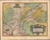
A very fine old color example of Abraham Ortelius' 1595 map of Gelderland (also known as Geulders, or as Geldria or Gelriae in Latin) in the central part of the Netherlands.
Natural features are also cataloged in great detail, especially the complex system of rivers, tributaries, and smaller waterways running through the region. The Zuiderzee is displayed at bottom-left with ships firing guns, a likely reference to the ongoing conflict with Habsburg Spain (in earlier states of the map, a single ship appears without gunsmoke). The Veluwe, also at bottom-left, is the largest forest in the Netherlands and contains notable areas of relatively high elevation.
An elaborate cartouche surrounds the title, while three scales are provided at top and an intricate border surrounds the map. Text on the verso provides a historical and geographical description of the region.
As with all Ortelius maps from the Theatrum, there can be considerable inconsistency and confusion in catalog listings. The OCLC independently catalogs one example of the map dated 1595 held by the Klassik Stiftung Weimar.
A Closer Look
Oriented towards the east, this map takes in the historical region of Gelderland, a duchy at the start of the Eighty Years’ War (1568 - 1648) that became a province under the Union of Utrecht (forerunner to the United Provinces). Cities and towns are indicated throughout, with larger towns and cities represented by illustrations of buildings. Arnhem (here as Arnhen) is located at center towards bottom-left, situated along the Nederrijn, a branch of the Rhine; to its right (south) is Nijmegen (Niemmegen), on the Waal, another branch of the Rhine. Utrecht appears at bottom-left.Natural features are also cataloged in great detail, especially the complex system of rivers, tributaries, and smaller waterways running through the region. The Zuiderzee is displayed at bottom-left with ships firing guns, a likely reference to the ongoing conflict with Habsburg Spain (in earlier states of the map, a single ship appears without gunsmoke). The Veluwe, also at bottom-left, is the largest forest in the Netherlands and contains notable areas of relatively high elevation.
An elaborate cartouche surrounds the title, while three scales are provided at top and an intricate border surrounds the map. Text on the verso provides a historical and geographical description of the region.
Historical Context
As with most of the Netherlands, Gelderland suffered the effects of warfare during the long struggle for Dutch independence. For instance, Zutphen (here as Zurphen) towards left was a strategically important and heavily fortified town where a combined Dutch-English force was defeated by the Army of Flanders in 1586 - 1587. In 1591, however, the city was retaken after a brief siege by Maurice of Orange during his highly successful counter-attack against Spanish forces in the 1590s. Arnhem and Nijmegen were similarly captured from Spain by joint Dutch-English forces, in 1585 and 1591, respectively, but remained in a precarious position for years and were subject to periodic sieges.Publication History and Census
Though undated, the present example conforms typographically to the 1595 Latin edition of the work. While the first edition of the Theatrum was released in 1570, Ortelius continually improved the work - both by adding new maps, and by refining the production of the book. Maps appearing in editions of the Theatrum in the 1580s and 1590s generally display, as here, a finer quality of color than those in the earlier issues of the work.As with all Ortelius maps from the Theatrum, there can be considerable inconsistency and confusion in catalog listings. The OCLC independently catalogs one example of the map dated 1595 held by the Klassik Stiftung Weimar.
CartographerS
Abraham Ortelius (April 14, 1527 - June 28, 1598) also known as Ortels, was a cartographer, geographer, and cosmographer of Brabant, active in Antwerp. He was the creator of the first modern atlas, Theatrum Orbis Terrarum and is a seminal figure in the history of cartography. Along with Gerard Mercator and Gemma Frisius, he was a founder of the Netherlandish school of cartography. His connections with Spain - culminating in his 1575 appointment as Royal Cartographer to King Phillip II of Spain - gave him unmatched access to Spanish geographical knowledge during a crucial period of the Age of Discovery. Ortelius was born in 1527 in Antwerp. In 1547 he entered the Antwerp Guild of Saint Luke as an illuminator of maps. He began trading in books, prints, and maps, traveling regularly to the Frankfurt book and print fair, where in 1554 he met Mercator. He accompanied Mercator on journeys throughout France in 1560 and it was at this time, under Mercator's influence, that he appears to have chosen his career as a scientific geographer. His first published geographic work appeared in 1564, an eight-sheet cordiform world map. A handful of other maps preceded the 1570 publication of the first edition of the Theatrum Orbis Terrarum, which would prove to be his life work. Appearing with but 53 maps in its first edition, Ortelius' work expanded with new maps added regularly. By 1592, it had 134 maps. Many of Ortelius' maps remained the standard for nearly a century. He traveled extensively, but his genius was as a compiler, locating the best informed maps on which to base his own. His contacts throughout Europe and extending even (via the Portuguese) to the Far East were formidable. Moreover, many of his maps were based on his own scholarship, particularly his historical works. His theories of geography were particularly ahead of his time with respect to the notion of continental drift, the possibility of which he mused on as early as 1596, and which would be proven correct centuries later.
In a sense his greatest achievement was his successful navigation of the religious and political violence endemic to his city throughout his adult life: The Dutch Revolt, or Eighty Years' War (1568 - 1648), fully embroiled Antwerp. Although outwardly and officially recognized as Catholic (Arias Montanus vouched for Ortelius' Catholic orthodoxy prior to his appointment as Royal Geographer), Ortelius was able to separate himself from the religious furor which characterized the war in the low countries. Ortelius showed a glimpse of himself in a letter to a friend, regarding humanist Justus Lipsius: 'I do not know whether he is an adherent of the Pope or a Calvinist, but if he has ears to hear, he will neither be one nor the other, for sins are committed on both sides'. Ortelius' own explorations of Biblical history in his maps, and the Christogram contained in his own motto, suggest him to be a religious man, but his abjuration of political religious authorities mark him as an individualist. His tombstone at St Michael's Præmonstratensian Abbey in Antwerp bears the inscription, Quietis cultor sine lite, uxore, prole. ('served quietly, without accusation, wife, and offspring.') More by this mapmaker...
Christian Sgrooten (c. 1525 - c. 1604) was a Dutch cartographer whose output found its greatest longevity in the copies of his maps made by Abraham Ortelius. Nothing is known of his childhood or training. His first recorded map dates to 1557 (a manuscript map of the woods near Gelderland). He was able, on the strength of this piece, to become royal geographer to Philip II, for whom he began to produce surveys of the Low Countries. He developed a relationship with Hieronymous Cock, who printed a number of his works - which we know only thanks to Ortelius, since only a handful of Cock's editions of Sgrooten are known to survive. Sgrooten would in the 1570s produce a number of maps of the Holy Land and Jerusalem and the Danube; he was commissioned to produce a manuscript atlas for the Duke of Alva in 1568, which was delivered yet unfinished in 1573 and survived in a singlle copy. A second atlas in 1592, also manuscript, was completed. Despite the limited dissemination of his work, Sgrooten was well esteemed by both Ortelius and Mercator; De Jode, too, used Sgrooten's maps as a source for some of his work. Learn More...
Source
Ortelius, A., Theatrum Orbis Terrarum, (Antwerp: Plantin) 1595.
Abraham Ortelius' magnum opus, Theatrum Orbis Terrarum, was the world's first regularly produced atlas, which 'set the standards for later atlases . . . It was the first undertaking of its kind to reduce the best available maps to an uniform format.' (Koeman) A modestly-sized work of fifty-three maps in its first edition of May 1570, it was an immediate success: there were three further editions that year, and the work remained in print for a total of 32 editions, the last of which was 1641, well after its author's 1598 death. Ortelius added to his atlas constantly, and by 1595 the Theatrum contained 147 maps. Ortelius is renowned generally as an editor, and indeed much of the Theatrum is compiled from a variety of sources: in such cases, Ortelius was scrupulous in naming his sources. But Ortelius was also a mapmaker in his own right: many of his maps are a distillation of various sources into his own work, and there were many maps - particularly in his atlas of Biblical and ancient history Parergon - which were entirely Ortelius' work. In his role as an editor, Ortelius followed in the footsteps of Munster, whose Cosmographia was, until Ortelius, the best window on the world for the curious European reader. In terms of the artistry of his maps, Ortelius oversaw the first great flourishing of copperplate engraving in the service of cartography to occur in Northern Europe. Ortelius' work provided the model for the atlases of Mercator, Hondius, Blaeu and all their progeny in the 17th century - many of whom were to produce faithful editions of Ortelius' maps in their own productions.
Condition
Very good. Generous margins. Superb original color. Slight foxing.
References
OCLC 551923462.