This item has been sold, but you can get on the Waitlist to be notified if another example becomes available, or purchase a digital scan.
1665 Kircher Map of the World (Earliest Map of World to Show Currents)
GeoHydro-kircher-1665$350.00

Title
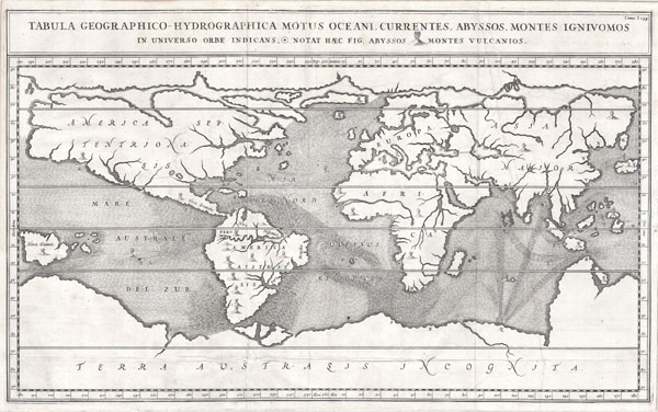
Tabula Geographico-Hydrographica Motus Oceani, Currentes, Abyssos, Montes Igniuomus in Universo Orbe Indicans Notat Haec Fig. Abyssos Montes Vulcanios.
1665 (undated) 13.5 x 22 in (34.29 x 55.88 cm)
1665 (undated) 13.5 x 22 in (34.29 x 55.88 cm)
Description
A rare and spectacular 1665 map of the world by the extraordinary Germany scholar Athanasius Kircher. This is most likely the first world map to depict the oceans currents. Shows the entire world in accordance with Kircher's hydro-geographic theory that tides and currents are caused by water moving to and from a massive subterranean ocean. Kircher postulated that water entered and exited the subterranean ocean via a number of great abysses situated around the globe. This map expounds on Kircher's theories by noting the abysses and the currents they create as well as the locations of the world's known volcanoes. Between the Mediterranean Sea, the Black Sea, the Caspian Sea, and the Persian Gulf, Kircher theorized massive tunnels and a complex interchange of water flows. These tunnels are noted most particularly between the Black and Caspian Sea and between the Mediterranean and the Persian Gulf. Antarctica is shown along the southern part of the map. In the North a great open northwest passage is depicted running all the way across the map. Shows New Guinea and a suggestion of Australia attached to the 'Australsis Incognita' mainland. Africa is shown with considerably greater accuracy than many maps drawn hundreds of years later – particularly with regard to Niger and Nile River Systems. North America and South America are both wildly malformed, indicating a relatively sketchy knowledge of the continent. Korea is shown as an Island and Japan appears as only a single island.
Cartographer
Athanasius Kircher (c. 1601 - 1680) was a 17th century German Jesuit scholar and one of the most respected and remarkable men of his time. A master of languages, mathematics, science, geography, physics and oriental studies, many consider Kircher to be 'the last true Renaissance man.' Kircher attained almost global fame in his lifetime for his numerous scholarly publications. Indeed, Kircher was the first documented scholar able to fully support himself on his own work, which, in his case, included some forty volumes on diverse fields. As a Catholic in Germany, Kircher was frequently at odds with the rising powers of Protestantism. Consequently, in 1628 he joined the priesthood and after extensive world travels eventually settled in Rome. There he was employed as a Professor of Mathematics and Oriental Languages at the Collegio Romano. Inspired by the eruption of Vesuvius in 1637 and the two weeks of earthquakes that shook Calabria in 1638, Kircher turned his considerable intellect to the natural world. Kircher's research into Geography and Oceanography culminated in the postulation that tides and currents were caused by water moving to and from a great subterranean ocean. Kircher published his geographic work in the important 1664 Mundus Subterraneus, which in addition to several world and oceanic charts, included a fascinating map of Atlantis. Kircher is nonetheless, not unimpeachable. One anecdote tells how a rival scholar presented Kircher with a manufactured gibberish manuscript he claimed to be an recently discovered ancient Egyptian text in need of translation. Kircher produced the translation instantly. In addition to his significance as a scholar, Kircher is best known for his invention of the Magic Lantern, precursor to modern cinema. He also founded the Museum Kircherianum in Rome. More by this mapmaker...
Source
Mundus Subterranous (1665 Issue)
Condition
Very good condition. Minor damage on original fold line near S in 'Australsis'.
References
Shirley, Rodney W., The Mapping of the World: Early Printed World Maps 1472-1700, page 436.