This item has been sold, but you can get on the Waitlist to be notified if another example becomes available.
1584 Mercator Edition of Ptolemy's Proto-Atlas: Expanded, Old Color
Geographiae-mercatorptolemy-1584$17,500.00


Title
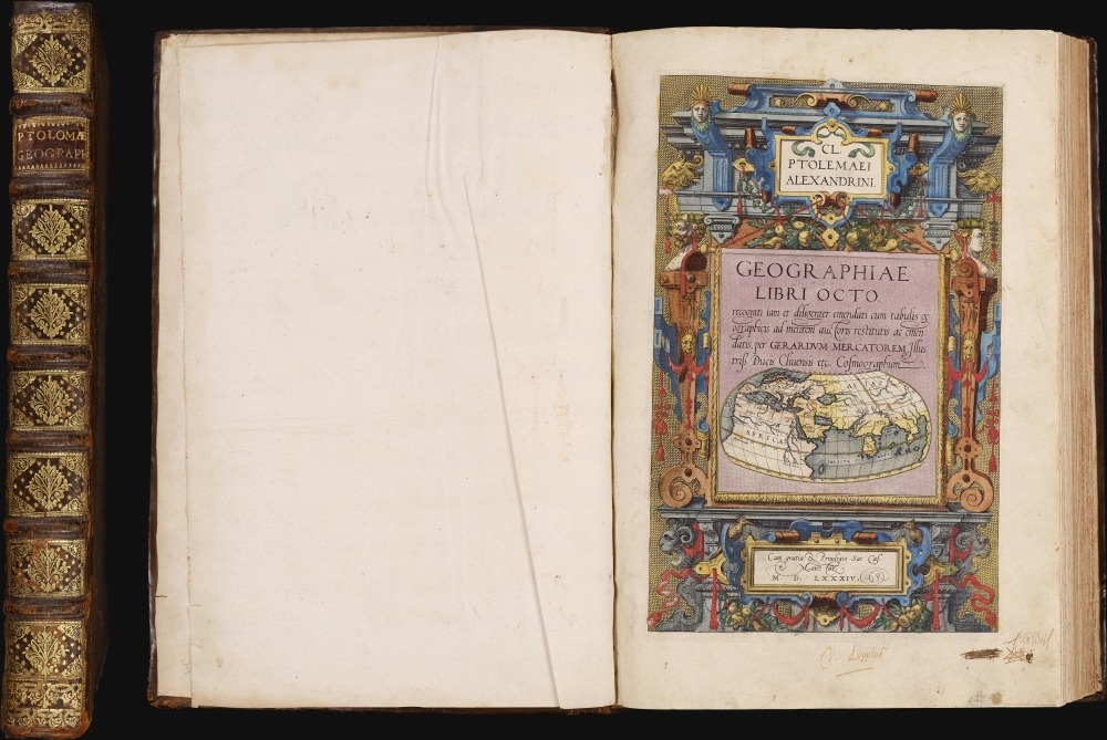
Cl Ptolemaei Alexandrini Geographiae libri octo: recognitiiam diligenter emendati cum tabulis geographicis ad mentem auctoris restitutis ac emendatis, per Gerardum Mercatorem.
1584 (undated) 16.5 x 11.25 in (41.91 x 28.575 cm)
1584 (undated) 16.5 x 11.25 in (41.91 x 28.575 cm)
Description
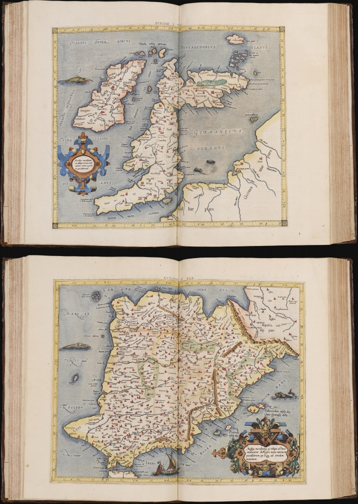
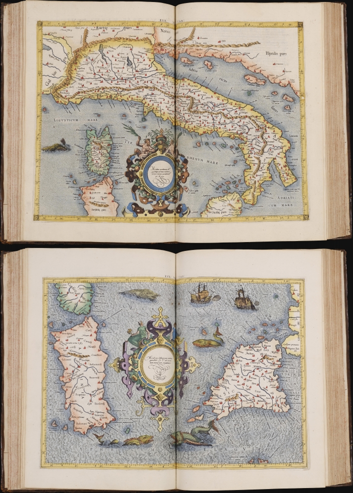
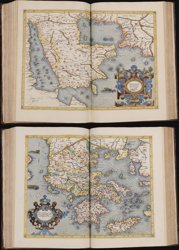
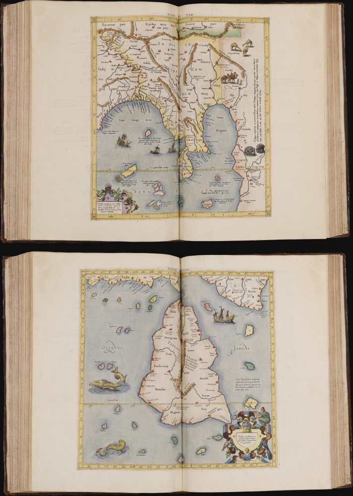
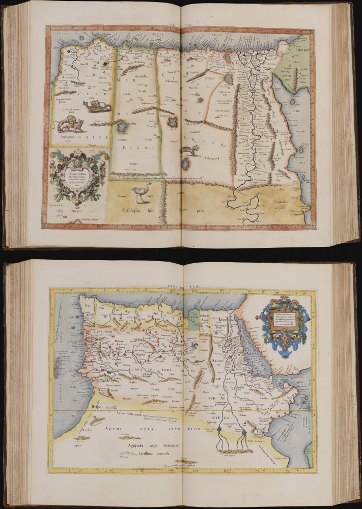
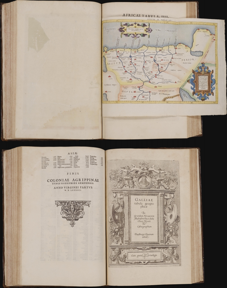
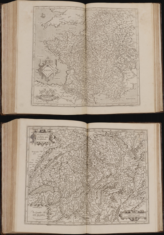
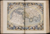
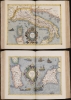
This is a superb example of Gerard Mercator's Cl Ptolemaei Alexandrini Geographiae Libri Octo: the 1584 first edition of the full proto-atlas, featuring Willibald Pirckheimer's translation of Claudius Ptolemy's text edited by Arnold Mylius, accompanied by 28 maps in rich, original color. Moreover, the present volume is bound with Mercator's contemporary atlas of France and the Low Countries, Galliae Tabule Geographicae. These volumes were probably joined in the 18th century when this volume was bound. The book thus presents Mercator's earliest published books in a superb, unique example. It is one of the few of Mercator's books to be published in his lifetime.
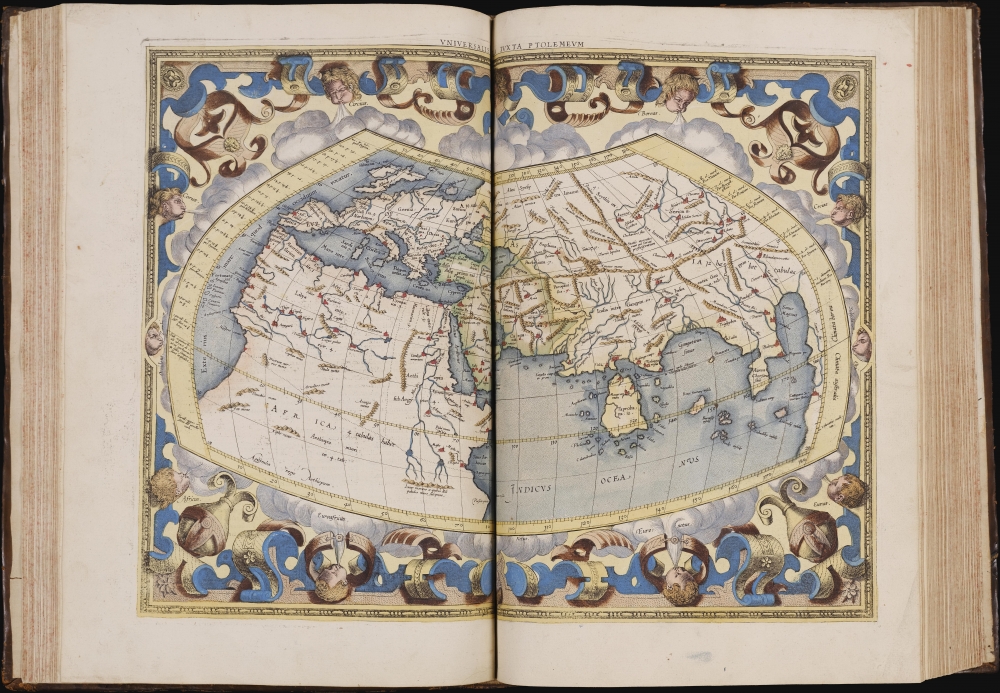
Gerard Mercator's edition of Ptolemy bloomed out of his life's work of attempting to reconcile the Alexandrian giant's geographic framework with the real world, as was increasingly revealed by exploration and study. (Indeed, a criticism of much of Mercator's modern work has been his reliance upon, or obsession with, Ptolemaic lore.) Mercator edited and re-drafted the maps, consulting many printed and manuscript editions of Geographia, in order to present as clear a rendition of Ptolemy's original design as possible, intending to produce a definitive edition. In this, he was successful: this edition became the standard text of Ptolemy's work. Previous editions, both copperplate and woodcut, were comparatively crude, omitted detail, and were rife with ambiguities. Mercator produced his versions of Ptolemy's maps using the latest engraving techniques, surpassing any that came before. Mercator's maps were more beautifully presented than any earlier Ptolemy; his own innovations in the use of italic fonts allowed for the legible inclusion of more detail than prior iterations. Also, Mercator presented Ptolemy's maps on modern projections, dispensing with the trapezoidal projections employed in most earlier editions. Remarkably, Mercator not only commanded the disciplines of cosmography, astronomy, and geography needed to draw the maps, but he was also an adept and innovative engraver: he was, therefore, singular in his ability to be involved in every stage of the production of a map.
The maps of his Ptolemy were among the first cartographic works to benefit from Mercator's innovations in engraved text. In 1540, Mercator produced the first instructional handbook in the engraving of italics to appear outside of Italy. The application of this typeface in cartography saw its genesis in the maps appearing in this work, but had far-reaching influence: 'the beauty and legibility of the best sixteenth and seventeenth-century Dutch maps can be traced in large measure to Mercator's influence.' (Karrow)
A Beautiful Example
The present book - handsomely bound in 18th-century calf, with a gilt spine - is unusually wide-margined throughout and remarkably clean and free of mends. All the maps are of early printings, bold and sharp. Moreover, the maps of the first section - the Ptolemaic maps - are illuminated with original color of a very high quality. It is a premier example of what was intended, from the start, to be the definitive edition of a foundational geographical work.The Finest Ptolemy
European exploration in the late 15th and early 16th centuries resulted in a massive expansion of the known world, far superseding Claudius Ptolemy's 2nd-century geographical knowledge. And yet, mapmakers continued to publish editions of Ptolemy - often simultaneously with modern maps reflecting the new discoveries. There were two reasons for this. First, Ptolemy's geography was among the only obtainable references to the locations of antiquity, shedding light on Humanistic attempts to recover and understand ancient literature. Second, Ptolemy's methodology remained essential and authoritative. By employing his great innovation - laying out a grid and assigning coordinates to real-world locations - one could produce a mathematical representation of the world, clearly showing the distances between known features. Every geographer of the Age of Discovery embraced Ptolemy's methodologies to absorb new discoveries. Any geographer, before developing new work, needed to understand the Ptolemaic foundations of their discipline. Consequently, editions of Ptolemy would continue to be printed well into the 18th century. Manuscript and print editions of Ptolemy were produced during the 15th and 16th centuries, with the maps included (with varying levels of sophistication and success).Gerard Mercator's edition of Ptolemy bloomed out of his life's work of attempting to reconcile the Alexandrian giant's geographic framework with the real world, as was increasingly revealed by exploration and study. (Indeed, a criticism of much of Mercator's modern work has been his reliance upon, or obsession with, Ptolemaic lore.) Mercator edited and re-drafted the maps, consulting many printed and manuscript editions of Geographia, in order to present as clear a rendition of Ptolemy's original design as possible, intending to produce a definitive edition. In this, he was successful: this edition became the standard text of Ptolemy's work. Previous editions, both copperplate and woodcut, were comparatively crude, omitted detail, and were rife with ambiguities. Mercator produced his versions of Ptolemy's maps using the latest engraving techniques, surpassing any that came before. Mercator's maps were more beautifully presented than any earlier Ptolemy; his own innovations in the use of italic fonts allowed for the legible inclusion of more detail than prior iterations. Also, Mercator presented Ptolemy's maps on modern projections, dispensing with the trapezoidal projections employed in most earlier editions. Remarkably, Mercator not only commanded the disciplines of cosmography, astronomy, and geography needed to draw the maps, but he was also an adept and innovative engraver: he was, therefore, singular in his ability to be involved in every stage of the production of a map.
The maps of his Ptolemy were among the first cartographic works to benefit from Mercator's innovations in engraved text. In 1540, Mercator produced the first instructional handbook in the engraving of italics to appear outside of Italy. The application of this typeface in cartography saw its genesis in the maps appearing in this work, but had far-reaching influence: 'the beauty and legibility of the best sixteenth and seventeenth-century Dutch maps can be traced in large measure to Mercator's influence.' (Karrow)
Publication History and Census
Mercator's Ptolemaic maps first saw print in Duisberg in 1578 as Tabulae Geographicae Cl: Ptoleme̜i, ('The Geographical Tables of Cl. Ptolemy). Karrow terms this a first edition, but as this printing lacked Ptolemy's text (the essence of any Ptolemy since no actual maps by Ptolemy survive), this should be considered as a different book. This edition of the book - Karrow's second edition, but the first edition to include the body of Ptolemy's work, translated by Pirckheimer and edited by Mylius - was printed in Cologne in 1584. The plates later passed to Jodocus Hondius, his successor, who issued editions in the early 17th century. In 1694, the plates were sold at auction to François Halma (1653 - 1722), who reworked them and published editions in 1695, 1698, and 1704. A final edition was published in 1730 by R. and J. Wetstein and G. Smith. Some 20 examples of this 1584 Ptolemy are cataloged in institutional collections. We see no cataloged examples of the work that include the modern 1585 maps; the present example is, in this respect, quite unique.CartographerS
Gerard Mercator (March 5, 1512 - December 2, 1594) is a seminal figure in the history of cartography. Mercator was born near Antwerp as Gerard de Cremere in Rupelmonde. He studied Latin, mathematics, and religion in Rupelmonde before his Uncle, Gisbert, a priest, arranged for him to be sent to Hertogenbosch to study under the Brothers of the Common Life. There he was taught by the celebrated Dutch humanist Georgius Macropedius (Joris van Lanckvelt; April 1487 - July 1558). It was there that he changed him name, adapting the Latin term for 'Merchant', that is 'Mercator'. He went on to study at the University of Louvain. After some time, he left Louvain to travel extensively, but returned in 1534 to study mathematics under Gemma Frisius (1508 - 1555). He produced his first world map in 1538 - notable as being the first to represent North America stretching from the Arctic to the southern polar regions. This impressive work earned him the patronage of the Emperor Charles V, for whom along with Van der Heyden and Gemma Frisius, he constructed a terrestrial globe. He then produced an important 1541 globe - the first to offer rhumb lines. Despite growing fame and imperial patronage, Mercator was accused of heresy and in 1552. His accusations were partially due to his Protestant faith, and partly due to his travels, which aroused suspicion. After being released from prison with the support of the University of Louvain, he resumed his cartographic work. It was during this period that he became a close fried to English polymath John Dee (1527 - 1609), who arrived in Louvain in 1548, and with whom Mercator maintained a lifelong correspondence. In 1552, Mercator set himself up as a cartographer in Duisburg and began work on his revised edition of Ptolemy's Geographia. He also taught mathematics in Duisburg from 1559 to 1562. In 1564, he became the Court Cosmographer to Duke Wilhelm of Cleve. During this period, he began to perfect the novel projection for which he is best remembered. The 'Mercator Projection' was first used in 1569 for a massive world map on 18 sheets. On May 5, 1590 Mercator had a stroke which left him paralyzed on his left side. He slowly recovered but suffered frustration at his inability to continue making maps. By 1592, he recovered enough that he was able to work again but by that time he was losing his vision. He had a second stroke near the end of 1593, after which he briefly lost speech. He recovered some power of speech before a third stroke marked his end. Following Mercator's death his descendants, particularly his youngest son Rumold (1541 - December 31, 1599) completed many of his maps and in 1595, published his Atlas. Nonetheless, lacking their father's drive and genius, the firm but languished under heavy competition from Abraham Ortelius. It was not until Mercator's plates were purchased and republished (Mercator / Hondius) by Henricus Hondius II (1597 - 1651) and Jan Jansson (1588 - 1664) that his position as the preeminent cartographer of the age was re-established. More by this mapmaker...
Claudius Ptolemy (83 - 161 AD) is considered to be the father of cartography. A native of Alexandria living at the height of the Roman Empire, Ptolemy was renowned as a student of Astronomy and Geography. His work as an astronomer, as published in his Almagest, held considerable influence over western thought until Isaac Newton. His cartographic influence remains to this day. Ptolemy was the first to introduce projection techniques and to publish an atlas, the Geographiae. Ptolemy based his geographical and historical information on the "Geographiae" of Strabo, the cartographic materials assembled by Marinus of Tyre, and contemporary accounts provided by the many traders and navigators passing through Alexandria. Ptolemy's Geographiae was a groundbreaking achievement far in advance of any known pre-existent cartography, not for any accuracy in its data, but in his method. His projection of a conic portion of the globe on a grid, and his meticulous tabulation of the known cities and geographical features of his world, allowed scholars for the first time to produce a mathematical model of the world's surface. In this, Ptolemy's work provided the foundation for all mapmaking to follow. His errors in the estimation of the size of the globe (more than twenty percent too small) resulted in Columbus's fateful expedition to India in 1492.
Ptolemy's text was lost to Western Europe in the middle ages, but survived in the Arab world and was passed along to the Greek world. Although the original text almost certainly did not include maps, the instructions contained in the text of Ptolemy's Geographiae allowed the execution of such maps. When vellum and paper books became available, manuscript examples of Ptolemy began to include maps. The earliest known manuscript Geographias survive from the fourteenth century; of Ptolemies that have come down to us today are based upon the manuscript editions produced in the mid 15th century by Donnus Nicolaus Germanus, who provided the basis for all but one of the printed fifteenth century editions of the work. Learn More...
Willibald Pirckheimer (December 5, 1470 - December 22, 1530) was a German lawyer and humanist, and a key figure in the German Renaissance, best remembered for his role as a cultural patron. He was close friends with artist Albrecht Dürer and theologian Erasmus. He was born in Eichstätt to lawyer Johannes Pirckheimer, and sent to Padua and Pavia to study law. Back in Nuremberg he became influential: he was twice a member of the city council, and in 1499 he was chosen by the city to command Nuremberg's troops assigned to the Imperial army to fight against the Swiss during the Swabian War. But his involvement in the city went beyond civic affairs. He became a member of a group of humanists that included Hartmann Schedel (he of the 1493 Liber Chronicarum). He translated an array of classical texts into German, and produced an edition of Ptolemy's Geographia in 1525. (This would provide the basis for the text of Mercator's 1584 Ptolemy.) And he supported others in the arts, most notably his great friend Albrecht Dürer, educating him in the classics and funding his travels to Italy. Pirckheimer was also a patron of science, supporting astronomist and instrument maker Johannes Werner. Learn More...
Arnold Mylius (October 16, 1540 - November 17, 1604) was a German bookseller, editor, and printer, living and trading in Cologne between 1585 and 1604. He was born in Freimersheim, Germany. He was trained in Antwerp under Arnold Birckmann, and took over management of Birckmann's firm on behalf of his heirs and eventually taking over the Birckmann publishing house himself. During his time in Antwerp he would collaborate with luminaries such as Plantin. Possibly to escape the religious conflicts of the Low Countries, he left Antwerp for Cologne, where he would marry. He would publish over 200 books; his work extended into the geographical world with his edit of Willibald Pirckheimer's translation of Ptolemy's Geographia appearing in Gerard Mercator's 1584 Cl Ptolemaei Alexandrini Geographiae libri octo. Learn More...
Source
Ptolemy, C. and Mercator, G., Cl. Ptolemaei Alexandrini Geographiae Libri Octo recogniti iam et diligenter emendati cum tabulis geographicis ad mentem auctoris restitutis ac emendatis, (Cologne: von Kempen) 1584.
Condition
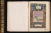
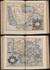
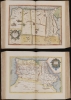
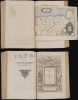
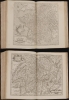
Folio (406 x 274 mm). 18th-century calf, spine in eight compartments with seven raised bands, gilt-lettered red morocco spine label (some light rubbing). Engraved architectural title-page with Ptolemaic world map, one small folding, one single page and 51 double-page engraved maps. Tiny burn hole in text page 79 affecting a few letters, some minor marginal dampstaining to text, else a fine example. Superb original color to Ptolemaic maps; Galliae Tabule Geographicae uncolored.
References
cf.OCLC 835143278. cf. Rumsey 10991. Van der Krogt, Peter, Koeman's Atlantes Neerlandici, 501.; cf 1:001.1 and 1:001.2.Karrow, R., Mapmakers in the Sixteenth Century, pp. 376-406.