This item has been sold, but you can get on the Waitlist to be notified if another example becomes available, or purchase a digital scan.
1661 Cluver and Jansson Map of Germany Under Caesar and Trajan
GermanyCaesarTrajan-cluver-1661$75.00

Title
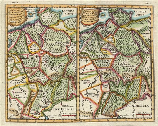
Populorum Germanium inter Rhenum et Albim descriptio ut inter Caesaris et Trajani imperia Incoluerunt. Populorum Germaniae inter Rhenum et Albim descriptio ut circa I. Caesaris aevum Incoluerunt.
1661 (undated) 8 x 10 in (20.32 x 25.4 cm) 1 : 4500000
1661 (undated) 8 x 10 in (20.32 x 25.4 cm) 1 : 4500000
Description
This is a stunning 1661 map by Philipp Cluver depicting Germany during Roman times. Essentially two maps on a single sheet, both maps cover the same region in Germany, viz. between the Rhine and Elbe Rivers and from Denmark south as far as Switzerland and Austria. The maps depict Germany under Caesar and Trajan and highlight the differences in political boundaries, place names, and other minor differences during the two stages in German history. Both maps exhibit vivid hand color and note rivers, towns and cities. Forests and mountains are beautifully rendered in profile. This map was issued by Philipp Cluver in the 1661 edition of Introductionis in Universam Geographiam tam veterem quam novam Libri.
Cartographer
Jan Jansson or Johannes Janssonius (1588 - 1664) was born in Arnhem, Holland. He was the son of a printer and bookseller and in 1612 married into the cartographically prominent Hondius family. Following his marriage he moved to Amsterdam where he worked as a book publisher. It was not until 1616 that Jansson produced his first maps, most of which were heavily influenced by Blaeu. In the mid 1630s Jansson partnered with his brother-in-law, Henricus Hondius, to produce his important work, the eleven volume Atlas Major. About this time, Jansson's name also begins to appear on Hondius reissues of notable Mercator/Hondius atlases. Jansson's last major work was his issue of the 1646 full edition of Jansson's English Country Maps. Following Jansson's death in 1664 the company was taken over by Jansson's brother-in-law Johannes Waesberger. Waesberger adopted the name of Jansonius and published a new Atlas Contractus in two volumes with Jansson's other son-in-law Elizée Weyerstraet with the imprint 'Joannis Janssonii haeredes' in 1666. These maps also refer to the firm of Janssonius-Waesbergius. The name of Moses Pitt, an English map publisher, was added to the Janssonius-Waesbergius imprint for maps printed in England for use in Pitt's English Atlas. More by this mapmaker...
Source
Cluver, P., Introductionis in Universam Geographiam tam veterem quam novam Libri, (Amsterdam) 1661.
Condition
Very good. Vivid colors. Original platemarks visible. Original centerfold exhibits minor wear.