This item has been sold, but you can get on the Waitlist to be notified if another example becomes available, or purchase a digital scan.
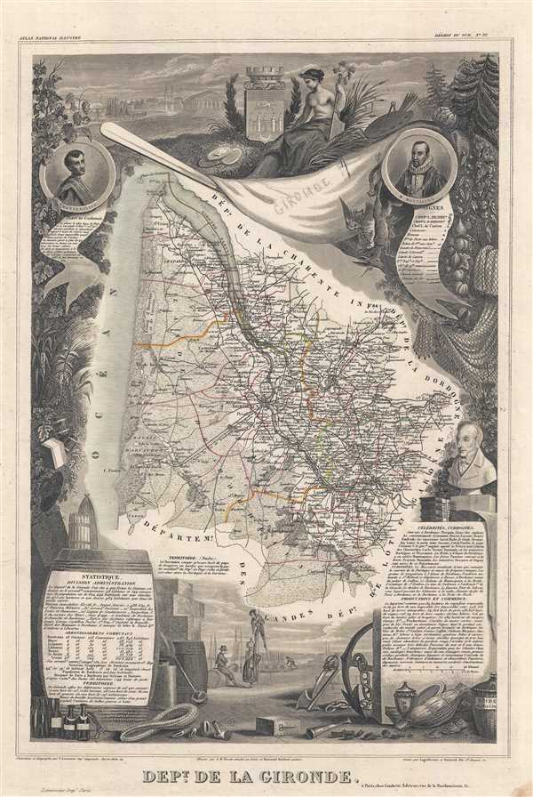
1852 Levasseur Map of Gironde (Bordeaux Wine Region)
Gironde3-levasseur-1852$100.00

Title
Dept. de la Gironde.
1852 (undated) 17.5 x 11.5 in (44.45 x 29.21 cm) 1 : 629000
1852 (undated) 17.5 x 11.5 in (44.45 x 29.21 cm) 1 : 629000
Description
This is a fascinating 1852 map of the French department of Gironde. This coastal department is the seat of the Bordeaux wine region and produces many of the world's finest reds. The city of Bordeaux is located at center. The map depicts numerous vineyards and chateaux and is surrounded by elaborate decorative engravings designed to illustrate both the natural beauty and trade richness of the land. There are statistics and a short textual history of the region on both the left and right sides of the map, including a list of famous French citizens who are from the region, such as Montesquieu.
The elaborate surround was drawn by Aristide Michel Perrot. Published by V. Levasseur in the 1852 edition of his Atlas National de la France Illustree.
The elaborate surround was drawn by Aristide Michel Perrot. Published by V. Levasseur in the 1852 edition of his Atlas National de la France Illustree.
CartographerS
Victor Levasseur (1800 - 1870), an important French engineer, cartographer, and engraver of the mid 19th century, held a number of important cartographically related political and educations posts in France. He is most famous for his Atlas National Illustré des 86 Départements et des Possessions de La France, a large decorative atlas of France, including his Planisphere and five important continental maps. Levasseur's maps are distinctive for their wide decorative margins containing elaborate depictions of the scenery, peoples, and trade goods of the areas he mapped. Levasseur maps are also known to offer a wealth of statistical data. Until recently, very few Levasseur Atlases migrated out of France where they were mostly used in public libraries and town halls. His work represents some of the last great decorative atlases of the 19th century. More by this mapmaker...
Aristide Michel Perrot (1793 - 1879) was a French geographer, cartographer, and essayist active during the 19th century. Perrot specialized in miniature maps that appear in numerous French atlases. Perrot was also a prolific writer and his works include geographic lexicons and several essays. Learn More...
Source
Levasseur, V., Atlas National Illustre des 86 Departements et des Possessions de La France Divise par Arrondissements, Cantons et Communea avec La Trace de Toutes Les Routes, Chemins,de fer et Canaux., 1852 edition.
Condition
Very good. Blank on verso.
References
Rumsey 0427.032 (1856 edition). Phillips (Atlases) 3003.