
This item below is out of stock, but another example (left) is available. To view the available item, click "Details."
Details
1943 Aluminum Company of America and Petruccelli Map of the World
$400.00
1943 Aluminum Company of America and Petruccelli Map of the World
GlobalWarPeace2-petruccelli-1943$162.50

Title
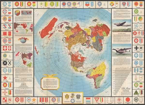
Global Map for Global War and Global Peace.
1943 (dated) 24 x 33.5 in (60.96 x 85.09 cm)
1943 (dated) 24 x 33.5 in (60.96 x 85.09 cm)
Description
This is a 1943 Antonio Petruccelli and Aluminum Company of America map of the world. The map utilizes the Azimuthal Equidistant Projection, or the North Pole Projection. Created with the purpose of illustrating true distances traveled by air, this projection allows for a more complete understanding of distance, as opposed to the Mercator Projection, for example.
With the North Pole at its center, the map at the center of the recto depicts the entire world, with Antarctica occupying the four corners. The countries are labeled as they would have been in 1943, including French West Africa, French Indochina, Tanganyika, Rhodesia, and Manchukuo, the puppet-state created by Japan in northeastern China. Along the left side, a description of the projection is included, along with an explanation of its use and importance. To the right one finds information about the production of airplanes, and why aluminum is the best choice when producing aircraft. This, of course, makes perfect sense since the map was produced by the Aluminum Company of America. The central map is bordered by the insignia painted on combat aircraft from 48 different nations, including the Free French Forces with the United States at the bottom center.
The verso, bears a highly detailed index of militaria during World War II. Along the top, Army and Navy aircraft squadron insignia are depicted, since the Air Force was not founded until after World War II. The information is divided into three different columns. On the left is information pertaining to the recognition of both friendly and enemy planes. Thirty different silhouettes of ‘fighting planes of the United Nations’ are given along with 22 silhouettes of enemy aircraft. Information about what do to if one observes a plane is included, as well as recognition characteristics. The insignia for the General Commands, the four Armies, the Army Corps, and Divisions are included along the bottom of both the left and right columns. The center column contains information about the organization of both Army and Navy air units, from the smallest (elements in the Army and Sections in the Navy) to the largest (the Army Air Force, each air force made up of four different commands, or a Navy Squadron). Information about the construction of aircraft and the fabrication of aluminum is supplied in this column. On the right, one finds diagrams of aerial maneuvers and U.S. Navy, Marine Corps, and Army insignia.
This map is an incredible find and one that will delight anyone interested in the Second World War. The map on the recto was drawn by Antonio Petruccelli and the entire map was published by the Aluminum Company of America.
Cartographer
Antonio Petruccelli (1907-1994) began his career as a textile designer. Petruccelli became a freelance illustrator in 1932 after winning several House Beautiful cover illustration contests. His work eventually appeared on the covers of Fortune, The New Yorker, Collier’s Today and House Beautiful magazines. ‘Tony was Mr. Versatility for Fortune. He could do anything, from charts and diagrams to maps, illustrations, covers, and caricatures,’ said Francis Brennan, the art director for Fortune. Over the course of his career, Petruccelli won several important design awards. Antonio Petruccelli died at age 87 on November 11, 1994. More by this mapmaker...
Condition
Very good. Wear along original fold lines. Verso repairs to fold separations.
References
OCLC 156937049.