Digital Image: 1724 Johannes Kip View or City Map of Gloucester, England
Gloucester-kip-1724_d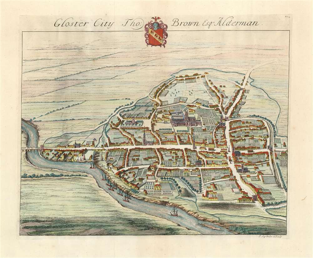

Title
Gloster City Tho: Brown Esq. Alderman.
1724 (undated) 13.5 x 16.5 in (34.29 x 41.91 cm)
1724 (undated) 13.5 x 16.5 in (34.29 x 41.91 cm)
Description
FOR THE ORIGINAL ANTIQUE MAP, WITH HISTORICAL ANALYSIS, CLICK HERE.
Digital Map Information
Geographicus maintains an archive of high-resolution rare map scans. We scan our maps at 300 DPI or higher, with newer images being 600 DPI, (either TIFF or JPEG, depending on when the scan was done) which is most cases in suitable for enlargement and printing.
Delivery
Once you purchase our digital scan service, you will receive a download link via email - usually within seconds. Digital orders are delivered as ZIP files, an industry standard file compression protocol that any computer should be able to unpack. Some of our files are very large, and can take some time to download. Most files are saved into your computer's 'Downloads' folder. All delivery is electronic. No physical product is shipped.
Credit and Scope of Use
You can use your digial image any way you want! Our digital images are unrestricted by copyright and can be used, modified, and published freely. The textual description that accompanies the original antique map is not included in the sale of digital images and remains protected by copyright. That said, we put significant care and effort into scanning and editing these maps, and we’d appreciate a credit when possible. Should you wish to credit us, please use the following credit line:
Courtesy of Geographicus Rare Antique Maps (https://www.geographicus.com).
How Large Can I Print?
In general, at 300 DPI, you should at least be able to double the size of the actual image, more so with our 600 DPI images. So, if the original was 10 x 12 inches, you can print at 20 x 24 inches, without quality loss. If your display requirements can accommodate some loss in image quality, you can make it even larger. That being said, no quality of scan will allow you to blow up at 10 x 12 inch map to wall size without significant quality loss. For more information, it is best consult a printer or reprographics specialist.
Refunds
If the high resolution image you ordered is unavailable, we will fully refund your purchase. Otherwise, digital images scans are a service, not a tangible product, and cannot be returned or refunded once the download link is used.
Cartographer
Johannes "Jan" Kip (1652 or 53 - 1722) was a Dutch draftsman, engraver and print dealer. Together with Leonard Knyff, he made a speciality of engraved views of English country houses and towns. Kip learned his trade under Stopendaal from 1668 to 1670. His own work began to appear in 1672. After producing works for the court of William ofOrange in Amsterdam, Kip relocated to London (following King William III and Queen Mary II in the 'Glorious Revolution' of 1688.) He then travelled around England documenting notable estates. to found a successful printselling business. He worked as an illustrator for other London publishers as well as his own. He is perhaps best known for the folio illustrations he produced for the 1708 Britannia Illustrata, 1708 and 65 plates he engraved for Sir Robert Atkyns' 1712 The Ancient and Present State of Glostershire, and for Le Nouveau Théâtre de la Grande Bretagne, 1715. More by this mapmaker...
Source
Smith, Joseph Nouveau theatre de la Grande Bretagne London 1724.
References
OCLC 163234524.