1853 Phillip Map of the Gold Fields of South Australia and Victoria
GoldFiledsSouthAustralia-phillip-1853$2,000.00

Title
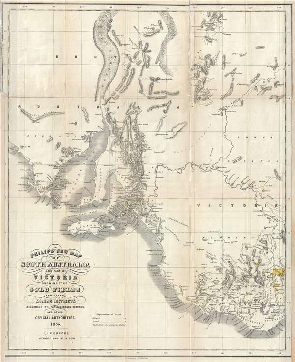
Philip's New Map of South Australia and Part of Victoria Showing the Gold Fields and other Mining Districts according to Parliamentary Returns and other Official Authorities.
1853 (dated) 24.25 x 19.5 in (61.595 x 49.53 cm) 1 : 1800000
1853 (dated) 24.25 x 19.5 in (61.595 x 49.53 cm) 1 : 1800000
Description
A remarkable and very rare 1853 map of the gold discoveries in South Australia and Victoria. The map covers from Coffin Bay to Cape Ottoway and as far north as Mount Hopeless. Major gold discoveries are highlighted in yellow, and these include discoveries near Adelaide on the Onkaparinga River and in Victoria along the Loddon River, near Mt. Freeth, Daisy Hill, on Creswell Creek, Mt. Boninyon, and Ballarat. Other mines, such as the Burra Burra copper mines are also identified. In addition, the map shows early railroad development between Port Adelaide and Adelaide.
This map accompanied John Capper's 1853 Emigrant's Guide to Australia. Although extremely rare today, the Capper Emigrant's Guide was popular in its day, going through at least three editions between 1853 and 1856.
This map accompanied John Capper's 1853 Emigrant's Guide to Australia. Although extremely rare today, the Capper Emigrant's Guide was popular in its day, going through at least three editions between 1853 and 1856.
Cartographer
George Philip (1800 - 1882) was a map publisher and cartographer active in the mid to late-19th century. Philip was born into a Calvinst family in Huntly, Aberdeenshire, Scotland. Around 1819 he apprenticed himself to William Grapel, a Liverpool printer and bookseller. Fifteen years later, in 1834, Philip founded his own Liverpool book and map firm. Philip's earliest cartographic ventures were mostly educational material issued in tandem with John Bartholomew Sr., August Petermann, and William Hughes. In 1848, Philip admitted his son, George Philip Jr. (1823 - 1902) into the firm, renaming it George Philip and Son Ltd. George Philip Jr. ran the firm until his death in 1902, by which time it had developed into a major publishing concern. His successors established the London Geographical Institute, a factory where they embraced modern printing techniques to produce thousands of economical and high quality maps. In April 1988, George Philip & Son was acquired by Octopus Publishing, a branch of Reed International. Nonetheless, today the firm trades and publishes to this day as George Philip and Son. More by this mapmaker...
Source
Capper, J., The Emigrant's Guide to Australia, (Liverpool: George Philip) 1853.
Condition
Good. Right and left margin extended. Backed on archival tissue. Some wear on original fold lines.
References
OCLC 225069043