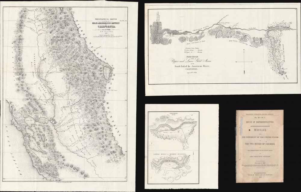
1848 Ord Maps of the Gold Discoveries in California (3 maps)
GoldRegionCalifornia-ord-1848$2,250.00


Title
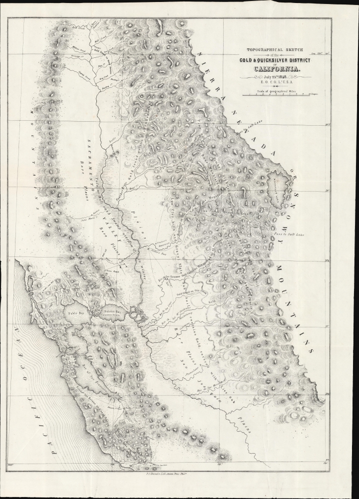
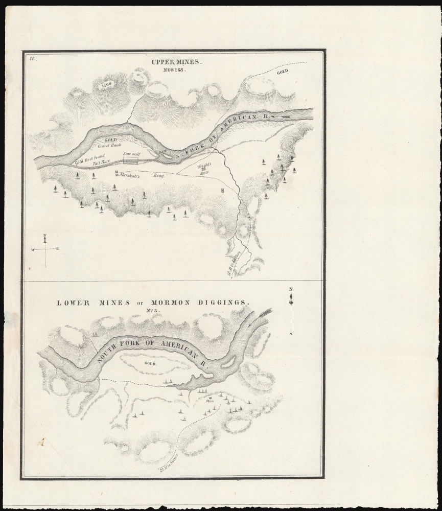
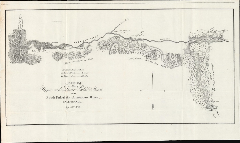
Topographical Sketch of the Gold and Quicksilver District of California. / Positions of the Upper and Lower Gold Mines on the South Fork of the American River, California. / Upper Mines. / Lower Mines or Mormon Diggings.
1848 (dated) 23.5 x 16.5 in (59.69 x 41.91 cm) 1 : 680000
1848 (dated) 23.5 x 16.5 in (59.69 x 41.91 cm) 1 : 680000
Description
This is a series of three 1848 maps by E. O. C. Ord of the gold discoveries in California's Sacramento Valley. These are, in aggregate, the first and most significant early maps illustrating the 1849 California Gold Rush, compiled to introduce the gold discovery to the U.S. Congress. As noted by Wheat, these were 'the first map[s] to make any pretense at cartographic accuracy after the gold discoveries,' thus being 'the most important of all the maps of 1848 . . . of paramount importance in any cartographical consideration of the gold rush.' The maps accompany Ex. Doc. No. 1, issued for the House of Representatives.
Wheat notes that this map also has Mormon significance. As Ord was preparing this map, the new 'Pass to Salt Lake' south of Mountain Lake [Tahoe], what become known as the 'Carson Road to the Diggings', was being opened by returning Mormon Battalion men bound for Utah.
The second map focuses on the Lower Mines, also called the Mormon Diggings, located slightly closer to Sutter's Fort than the Upper Mines (about 25 miles from Sutter's Fort), and also on the South Fork of the American River. Roughly corresponding to modern day Folsom, this was the first gold camp established after the discovery.
Both are attributed to Ord and Sherman.
A Closer Look - Gold and Quicksilver District of California
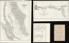
The largest and most significant map of the set is the Topographical Sketch of the Gold and Quicksilver District of California (23.5 x 16.5 in), issued on July 25, 1848, just months after the initial discovery of gold. Coverage centers on the Sacramento Valley, but extends west to include San Francisco Bay, and east to the Sierra Nevada Mountains, including Lake Tahoe, here labeled Mountain Lake. The map identifies road and river routes between San Francisco and Sutter's Ford, as well as further inland. Of significance, it notes points along the Sacramento River and various tributaries where gold had been discovered. South of San Francisco Bay, it also notes quicksilver (mercury) discoveries between Santa Clara and Santa Cruz.Wheat notes that this map also has Mormon significance. As Ord was preparing this map, the new 'Pass to Salt Lake' south of Mountain Lake [Tahoe], what become known as the 'Carson Road to the Diggings', was being opened by returning Mormon Battalion men bound for Utah.
A Closer Look - Positions of the Upper and Lower Gold Mines
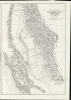
The second map in the set is Positions of the Upper and Lower Gold Mines on the South Fork of the American River, California (11 x 20 in), compiled on July 20, 1848. This map offers more detail on the immediate vicinity of Sutter's Fort and the American River, particularly the South Fork. Coverage embraces from the confluence of the Sacramento and American Rivers, where Sutter established his 'fort' eastward to the foothills of the Sierra Nevada Mountains. This is the primary zone of the early Gold Rush discoveries. This map is attributed to both Ord and Lt. William T. Sherman, of later Civil War fame.A Closer Look - Upper Mines / Lower Mines or Mormon Diggings
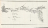
The final map, comprised of two maps on a sheet (9 x 10 in), offers even greater detail. The upper map focuses on the 'Upper Mines' near Sutter's actual mill, about 50 miles from Sutter's Fort. It marks the site where James W. Marshall first discovered gold, igniting the Gold Rush. It also notes Marshall's residence and 'Wright's Store'.The second map focuses on the Lower Mines, also called the Mormon Diggings, located slightly closer to Sutter's Fort than the Upper Mines (about 25 miles from Sutter's Fort), and also on the South Fork of the American River. Roughly corresponding to modern day Folsom, this was the first gold camp established after the discovery.
Both are attributed to Ord and Sherman.
Closer Look - Ex. Doc. No. 1
The maps accompany Ex. Doc. No. 1, a document published on December 5, 1848, for the House of Representatives. It contains Polk's address to the Thirtieth Congress, Second Session. It was this address that introduced Congress to the Gold Rush, as well as to the significance of the new lands acquired by the Treaty of Guadeloupe-Hidalgo. The report includes Polk's address, as well as supplementary letters from R. B. Mason, the military governor of Upper California reporting the gold discovery. They give greater context to the maps, which are referenced within.Historical Context: The California Gold Rush
The discovery of gold at John Sutter's mill by James Wilson Marshall (1810 - 1885) in January of 1848 was one of the most definitive moments in American history. Coming at the end of the Mexican-American War (1846 - 1848), the timing of the discovery could not have been more propitious. The combination of new seemly unlimited territory and the lure of gold led to a stampede of adventurers, prospectors, merchants, and homesteaders eager for a new life on the frontier. The Gold Rush was not limited to Americans crossing the Great Plains. European, Australian, and even Chinese immigrants rushed into California hungry for their part of the great strike. This Great Migration transformed the United States in the span of just a few years from a former colony into an expansive transcontinental nation on the cusp of becoming a world power.Publication History and Census
These maps were compiled by Edward Otho Cresap Ord and William Tecumseh Sherman in 1848. They were printed in the same year in Philadelphia by P. S. Duval lithography. The maps were included in both House and Senate documents prepared for the second session of the Thirtieth Congress. As government publications, they are well represented in institutional collections, although often survive in poor condition.CartographerS
Edward Otho Cresap Ord (October 18, 1818 - July 22, 1883) was an American army officer and engineer active in California in the mid to late 19th century. He was born in Cumberland, Maryland. According to family lore, his father, James Ord, was the illegitimate son of British monarch George VI and Maria Fitzherbert. He showed an early proficiency in mathematics, some calling him a genius, and in 1839 he graduated from West Point with an engineering degree. As it so happened, his West Point roommate was none other than William Tecumseh Sherman. He was commissioned as a Lieutenant in the 3rd U.S. Artillery, with whom he saw action in the Second Seminole War (1835 - 1842). After the Mexican-American War (1846 - 1848) Ord sailed on the USS Lexington via Cape Horn to the newly acquired territory of California - accompanying him were his West Point roomies Henry Halleck and William Tecumseh Sherman. They arrived just in time for the Gold Rush. Ord produced a seminal map of the Gold and Quicksilver district of California dated July 25, 1848 - the first published map of the California Gold Region. Later in the fall of 1848, Ord and Sherman, working for John Augustus Sutter, Jr., assisted the U.S. Army Corps of Engineers in a detailed survey of Sacramento - instrumental in creating that city's downtown grid. He went on to do survey work in the vicinity of Los Angeles and the Pacific Northwest. At the outbreak of the American Civil War (1861 - 1865), Ord was serving as Captain of Battery C, 3rd U.S. Artillery, and also as post commander at the U.S. Army's Fort Vancouver in Washington Territory. Returning east to fight in the war, he was assigned brigade commander of the Pennsylvania Reserves. He served with distinction through the war, seeing action at Dranesville, Hatchie Bridge, Luka, and Vicksburg, Crater, and Fort Harrison, where he was wounded. At the end of the Civil War, in 1865, Ord was assigned to investigate Confederate involvement in the assassination of Abraham Lincoln. By this time, Ord was a Major General. He retired from the army in 1881 to take a position under U. S. Grant as a civil engineer on the Mexican Southern Railroad. During this assignment, Ord's daughter, Roberta, married prominent Mexican general Jerónimo Treviño. Also in Mexico, Ord contracted yellow fever and died on his way home during a stopover in Havanna, Cuba. More by this mapmaker...
Peter Stephen Duval (1804 - February 8, 1886) was a prominent Philadelphia lithographer. He immigrated to Philadelphia from France in 1831 to take a job as a lithographer at the Philadelphia firm owned by Cephas Childs. In 1837, Childs retired and Duval took over the business. Over the course of the next thirty years, Duval would have several business partners including the Swiss-American engravers Charles and Frederick Bourquin (1808 - 1897). In 1857 his son Steven C. Duval joined the business. Peter Duval retired in 1869 but continued to be involved in his company until his death in 1886. Learn More...
Source
'Ex. Doc. No. 1. House of Representatives', Message from the President of the United States to the Two Houses of Congress, at the Commencement of the Second Session of the Thirtieth Congress, (Washington: Wendell and Van Benthuysen) 1848.
Condition
Very good. Minor margin repair. Accompanies unbound report.
References
Rumsey 3458.000. Wheat, C. I., Maps of the Gold Region, #51-53. Wheat, C. I., Mapping of the Transmississippi West, 1540 – 1861, v. 3, p. 52-53, #565.