1794 Laurie and Whittle Nautical Map of Northeastern India
Gordevare-lauriewhittle-1794$400.00

Title
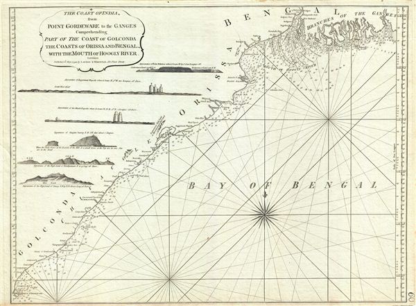
The Coast of India from Point Gordeware to the Ganges Comprehending Part of the Coast of Golconda, the Coasts of Orissa and Bengal, with the Mouth of Hoogly River.
1794 (dated) 18 x 24 in (45.72 x 60.96 cm) 1 : 1458000
1794 (dated) 18 x 24 in (45.72 x 60.96 cm) 1 : 1458000
Description
This is a fine example of Laurie and Whittle's 1794 nautical chart or maritime map of the Golconda Coast, the coast of Orissa and Bengal and the mouths of the Hooghly River, northeastern India. It covers from the mouths of the Ganges River as it empties into the Bay of Bengal, south as far as Point Gorgeware (Godavari Point) and Corigna Bay. Along the left border, the map includes six coastal profile views detailing Point Palmiras, Jaggernaut Pagoda (Jagannath Temple), the Black Pagoda (Konnark Sun Temple), Ganjam, the highlands of Bimilipatnam (Bheemilipatnam), and the highlands of Panary. The Jagannath Temple and the Konnark Sun Temple are two of the most renowned temples in India and important pilgrimage destinations Hindus. Laurie and Whittle also note the site of the 1766 Falmouth shipwreck.
Further north, The Hooghly River, one of the most important trade and transport arteries during the colonial era, and the reason the British chose to settle in Calcutta, was witness to several battles. Perhaps the most important being the Battle of Plassey of 1759, where the British East India Company defeated Nawab of Bengal and his French allies, leading to British rule in Bengal, and eventually the entire subcontinent. Also of note, the Gahirmata Beach (near Point Palmir and Kannaka marked here), is the world's most important nesting beach for the Olive Ridley Sea Turtles.
The map offers rich detail including countless depth soundings, notes on the sea floor, commentary on reefs, rhumb lines, sandbars, shoals, pagodas, place names and a wealth of other practical information for the mariner. This map was published by Laurie and Whittle from their offices at 53 Fleet Street, London, on May 12, 1794. It was issued independently as well as offered in their 1797 East-India Pilot, or Oriental Navigator.
Cartographer
Laurie and Whittle (fl. 1794 - 1858) were London, England, based map and atlas publishers active in the late 18th and early 19th century. Generally considered to be the successors to the Robert Sayer firm, Laurie and Whittle was founded by Robert Laurie (c. 1755 - 1836) and James Whittle (1757-1818). Robert Laurie was a skilled mezzotint engraver and is known to have worked with Robert Sayer on numerous projects. James Whittle was a well-known London socialite and print seller whose Fleet Street shop was a popular haunt for intellectual luminaries. The partnership began taking over the general management of Sayer's firm around 1787; however, they did not alter the Sayer imprint until after Sayer's death in 1794. Apparently Laurie did most of the work in managing the firm and hence his name appeared first in the "Laurie and Whittle" imprint. Together Laurie and Whittle published numerous maps and atlases, often bringing in other important cartographers of the day, including Kitchin, Faden, Jefferys and others to update and modify their existing Sayer plates. Robert Laurie retired in 1812, leaving the day to day management of the firm to his son, Richard Holmes Laurie (1777 - 1858). Under R. H. Laurie and James Whittle, the firm renamed itself "Whittle and Laurie". Whittle himself died six years later in 1818, and thereafter the firm continued under the imprint of "R. H. Laurie". After R. H. Laurie's death the publishing house and its printing stock came under control of Alexander George Findlay, who had long been associated with Laurie and Whittle. Since, Laurie and Whittle has passed through numerous permeations, with part of the firm still extant as an English publisher of maritime or nautical charts, 'Imray, Laurie, Norie and Wilson Ltd.' The firm remains the oldest surviving chart publisher in Europe. More by this mapmaker...
Source
Laurie, R., and Whittle, J., The East-India Pilot, or Oriental Navigator, on One Hundred and Eighteen Plates: Containing a Complete Collection of Charts and Plans, &c., &c. for the Navigation not only of the Indian and China Seas, but of those also between England and the Cape of Good-Hope; Improved and Chiefly Composed from the Last Work of M. D'Apres de Mannevillette; with Considerable Additions, from Private Manuscripts of the Dutch, and from Draughts and Actual Surveys Communicated By Officers of the East-India Company A New Edition, Containing One Hundred and Five Charts. (London: Laurie and Whittle) 1797.
Condition
Very good. Original platemark visible.