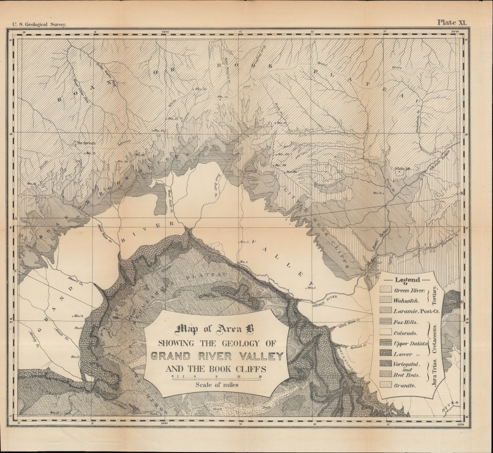
A detailed 1876 U.S. Geological Survey map of Colorado River Valley in southwestern Colorado and southeastern Utah. At the time, this area was undergoing a demographic shift, as the native Ute people were displaced to make way for American miners and settlers.
A Closer Look
The Colorado River, then known as the Grand River, snakes across the center of the map, fed by multiple tributaries. Waterways, including springs, are labeled, along with plateaus, mountains, stations used by U.S.G.S. surveyors, and other features. Shading indicates geological strata keyed to a legend at the bottom-right.Historical Context
The Ute people were traditionally hunter-gatherers who ranged over a vast territory centered around Pikes Peak. Beginning in the mid-1870s, the Ute were confined to western Colorado. By the late 1870s, mineral wealth was discovered, and the arrival of soldiers and settlers caused tensions to escalate. In 1881, the Ute territory was abolished, and the Ute were removed to a smaller reservation. Afterward, more settlers moved into the valley seen here, and the town of Grand Junction grew at the intersection of several railway lines (near Station 2). The valley proved especially suitable for viticulture, becoming known as Colorado Wine Country. Although the river came to be known as the Colorado, the surrounding country is still referred to as Grand Valley.Publication History and Census
This map was surveyed by the U.S. Geological Survey in 1876 to accompany the report 'Geological report of the Grand River District (Colorado)' published in the Survey's 10th annual report. It is attributed to Albert Charles Peale, though his name does not appear here. The map is not independently cataloged by any institution and only occasionally appears on the market.
CartographerS
The United States Geological Survey (1878 - Present), aka the U.S.G.S., is a scientific agency of the United States government, which was founded in 1879. USGS scientists study the landscape of the United States, its natural resources, and the natural hazards that threaten it. The organization has four major science disciplines: biology, geography, geology, and hydrology. It is a bureau of the United States Department of the Interior and is the department's only scientific agency.
More by this mapmaker...
Albert Charles Peale (April 1, 1849 - December 5, 1914) was a geologist, mineralogist, and member of the U.S. Geological and Geographical Survey of the Territories (also known as the Hayden Survey). He studied at Philadelphia's Central High School and trained to become a physician, earning a medical degree though never practicing medicine. In 1871, he joined Hayden and would spend most of the next thirty years with the Survey of the Territories and its successor, the U.S. Geological Survey. He later worked as a paleobotanist at the Smithsonian. Several natural features in Wyoming, Idaho, and Utah are named for him. Learn More...
Source
Peale, A., 'Geological report of the Grand River district (Colorado)', Annual Report of the United States Geological and Geographical Survey of the Territories, Vol. 10, (Washington, D.C.: Government Printing Office) 1878.
Good. Light wear along original folds with small pinholes at some intersections. Some chips along edge. Left edge trimmed unevenly from original binding in report. Some foxing in left margin.