Digital Image: 1897 Graham Chromolithograph Bird's-Eye View of New York City
GreaterNewYork-graham-1897_d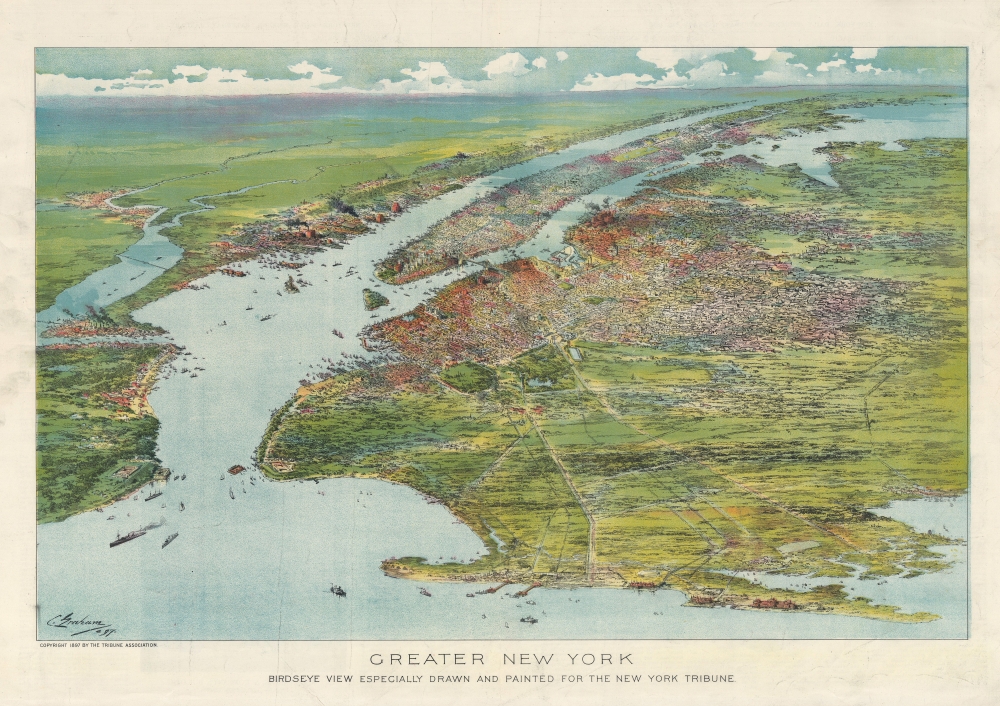


Title
Greater New York. Birdseye View Especially Drawn and painted for the New York Tribune.
1897 (dated) 16 x 23 in (40.64 x 58.42 cm)
1897 (dated) 16 x 23 in (40.64 x 58.42 cm)
Description
FOR THE ORIGINAL ANTIQUE MAP, WITH HISTORICAL ANALYSIS, CLICK HERE.
Digital Map Information
Geographicus maintains an archive of high-resolution rare map scans. We scan our maps at 300 DPI or higher, with newer images being 600 DPI, (either TIFF or JPEG, depending on when the scan was done) which is most cases in suitable for enlargement and printing.
Delivery
Once you purchase our digital scan service, you will receive a download link via email - usually within seconds. Digital orders are delivered as ZIP files, an industry standard file compression protocol that any computer should be able to unpack. Some of our files are very large, and can take some time to download. Most files are saved into your computer's 'Downloads' folder. All delivery is electronic. No physical product is shipped.
Credit and Scope of Use
You can use your digial image any way you want! Our digital images are unrestricted by copyright and can be used, modified, and published freely. The textual description that accompanies the original antique map is not included in the sale of digital images and remains protected by copyright. That said, we put significant care and effort into scanning and editing these maps, and we’d appreciate a credit when possible. Should you wish to credit us, please use the following credit line:
Courtesy of Geographicus Rare Antique Maps (https://www.geographicus.com).
How Large Can I Print?
In general, at 300 DPI, you should at least be able to double the size of the actual image, more so with our 600 DPI images. So, if the original was 10 x 12 inches, you can print at 20 x 24 inches, without quality loss. If your display requirements can accommodate some loss in image quality, you can make it even larger. That being said, no quality of scan will allow you to blow up at 10 x 12 inch map to wall size without significant quality loss. For more information, it is best consult a printer or reprographics specialist.
Refunds
If the high resolution image you ordered is unavailable, we will fully refund your purchase. Otherwise, digital images scans are a service, not a tangible product, and cannot be returned or refunded once the download link is used.
Cartographer
Charles Graham (1852 - August 9, 1911) was an American artist, draftsman, cartographer, and lithographer. Born in Rock Island, Illinois, Graham was a self-taught artist and worked as a theater backdrop painter in Chicago. By 21, he was working for the Northern Pacific Railroad as a topographer/mapmaker. He moved to New York City at 23 and began working for Harper's Weekly, with his work appearing in nearly every issue between 1880 and 1892 or 1893. While at Harper's, he traveled the American West making art for the magazine. He left Harper's in 1893 to become a freelancer, contributing to the New York Herald, Collier's, and other magazines alongside continuing to create work for Harper's. He shifted from pencil drawing to watercolor and oil painting around this time. In 1893, Graham was designated the official artist of the World's Columbian Exposition (also known as the Chicago World's Fair). He lived in San Francisco from 1883 until 1896, when he returned to New York. He died in New York in 1911 after a long illness. More by this mapmaker...
References
OCLC 1200514332.