1780 Bellin Map of the Gulf of St. Lawrence, and Newfoundland
GulfSaintLawrence-bellin-1780$175.00
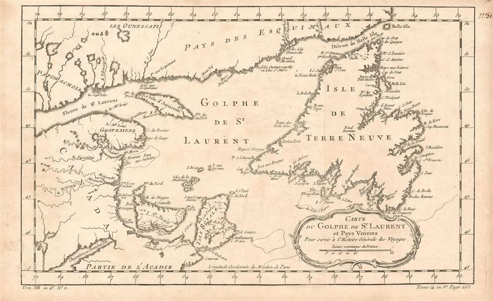

Title
Carte Du Golphe De St. Laurent et Pays Voisins : Pour servir a l'Histoire Generale des Voyage
1780 (undated) x 8 in (0 x 20.32 cm) 1 : 3100000
1780 (undated) x 8 in (0 x 20.32 cm) 1 : 3100000
Description
This is an attractive 1780 Bellin map of Acadia, the mouth of the Saint Lawrence River, and Newfoundland. It includes Anticosti island, Prince Edward Island (here named I. St. Jean) and Isle Royale (Cape Breton Island.) While a number of rivers are shown, the focus overall is on the coastlines and interior detail is sparse.
Publication History and Census
The map was executed in 1757 for inclusion in Prévost's Histoire générale des voyages, and was again printed in 1780 for Harpe's abridged edition of that work, one perhaps better known for its imaginative flourish than for its factuality. Nevertheless, despite the venue, Bellin was an authoritative geographer who drew on state-of-the-art knowledge for the maps he contributed. This map appears on the market from time to time, although OCLC only lists perhaps a dozen copies of the separate map in both editions combined. Prévost's Histoire and Harpe's abridged version of it are well represented in institutional collections.Cartographer
Jacques-Nicolas Bellin (1703 - March 21, 1772) was one of the most important cartographers of the 18th century. With a career spanning some 50 years, Bellin is best understood as geographe de cabinet and transitional mapmaker spanning the gap between 18th and early-19th century cartographic styles. His long career as Hydrographer and Ingénieur Hydrographe at the French Dépôt des cartes et plans de la Marine resulted in hundreds of high quality nautical charts of practically everywhere in the world. A true child of the Enlightenment Era, Bellin's work focuses on function and accuracy tending in the process to be less decorative than the earlier 17th and 18th century cartographic work. Unlike many of his contemporaries, Bellin was always careful to cite his references and his scholarly corpus consists of over 1400 articles on geography prepared for Diderot's Encyclopedie. Bellin, despite his extraordinary success, may not have enjoyed his work, which is described as "long, unpleasant, and hard." In addition to numerous maps and charts published during his lifetime, many of Bellin's maps were updated (or not) and published posthumously. He was succeeded as Ingénieur Hydrographe by his student, also a prolific and influential cartographer, Rigobert Bonne. More by this mapmaker...
Source
De la Harpe, Abrégé de l'histoire générale des voyages. - Paris, 1780
Condition
Very good condition. Two minor patches of scuffing with slight loss to border, reinstated in ms.
References
OCLC 633087077.