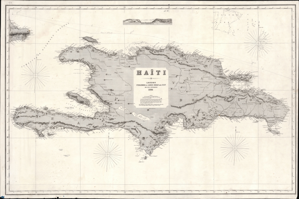
1864 Imray Nautical Chart or Map of Santo Domingo / Hispaniola / Haiti
HaitiSantoDomingo-imray-1864$900.00

Title
Haïti.
1864 (dated) 27.25 x 41 in (69.215 x 104.14 cm) 1 : 680000
1864 (dated) 27.25 x 41 in (69.215 x 104.14 cm) 1 : 680000
Description
This is a rare 1864 James Imray and Son blueback nautical chart or maritime map of Hispaniola or Santo Domingo, here identified as 'Haïti'. The chart is large and finely engraved with ample coastal detail, some inland topography, and depth soundings throughout. Pencil marks trace a Spanish voyage, likely out of Cadiz, along the island's northern coast.
This chart is extremely rare, with no recorded holdings of the map in this edition. Brown University has an 1882 edition. The Bibliothèque Nationale de France has another, dated 1867, and a third example is cataloged at the Museu Marítim de Barcelona.
Historical Context
When this map was issued, Hispaniola was divided between two rival powers despite being singularly identified as 'Haïti' here. Haiti, primarily occupied by French-speaking formerly enslaved people, occupied the eastern 2/3rds of the island. The Spanish-speaking Santo Domingo, today's Dominican Republic, occupied the eastern third. The entire island, at the time, was in political disarray. Haiti was controlled by Guillaume Fabre Nicolas Geffrard (1806 - 1878), the self-styled 'Duke of Tabara', a former general and the President of Haiti from 1859 to 1867. On the Dominican side of the island, Pedro Santana y Familias (1801 - 1864) was attempting to return Santo Domingo to Spanish rule despite significant internal protest, leading to the Dominican Restoration War (1863 - 1865). In the year after this map was made, Santana died, and Buenaventura Báez (1812 - 1884) established the Second Dominican Republic, becoming its first president.Blueback Charts
Blueback nautical charts began appearing in London in the late 18th century. Bluebacks, as they came to be called, were privately published large-format nautical charts known for their distinctive blue paper backing. The backing, a commonly available blue manila paper traditionally used by publishers to wrap unbound pamphlets, was adopted as a practical way to reinforce the low-quality paper used by private chart publishers to cut costs. That being said, not all blueback charts are literally backed with blue paper. The earliest known blueback charts include a 1760 chart issued by Mount and Page and a 1787 chart issued by Robert Sayer. The tradition took off in the early 19th century, when British publishers like John Hamilton Moore, Robert Blachford, James Imray, William Heather, John William Norie, Charles Wilson, David Steel, R. H. Laurie, and John Hobbs, among others, rose to dominate the chart trade. Bluebacks became so popular that the convention was embraced by chartmakers outside of England, including Americans Edmund March Blunt and George Eldridge, as well as Scandinavian, French, German, Russian, and Spanish chartmakers. Blueback charts remained popular until the late 19th century when government-subsidized organizations like the British Admiralty Hydrographic Office and the United States Coast Survey began issuing superior charts on high-quality paper that did not require reinforcement.Publication History and Census
This map was published in London by James Imray and Son, chartmakers, in 1864. This is most likely the first edition, as it is the earliest we have identified. Curiously, the map was printed on the back of another chart - depicting the Thames Estuary, also by Imray, giving some insight into the firm's 'recycling' operation.This chart is extremely rare, with no recorded holdings of the map in this edition. Brown University has an 1882 edition. The Bibliothèque Nationale de France has another, dated 1867, and a third example is cataloged at the Museu Marítim de Barcelona.
Cartographer
James Imray (May 16, 1803 - November 15, 1870) was a Scottish hydrographer and stationer active in London during the middle to latter part of the 19th century. Imray is best known as a the largest and most prominent producer of blue-back charts, a kind of nautical chart popular from about 1750 to 1920 and named for its distinctive blue paper backing (although not all charts that may be called "blue-backs" actually have a blue backing). Unlike government charts issued by the British Admiralty, U.S. Coast Survey, and other similar organizations, Imray's charts were a private profit based venture and not generally the result of unique survey work. Rather, Imray's charts were judicious and beautiful composites based upon pre-existing charts (some dating to the 17th century) and new information gleaned from governmental as well as commercial pilots and navigators. Imray was born in Spitalfields, England, the eldest son of a Jacobite dyer also named James. Imray did not follow his father profession, instead apprenticing to William Lukyn, a stationer. He established himself as a bookseller and bookbinder at 116 Minories Street, where he shared offices with the nautical chart publisher Robert Blanchford. In 1836 Imray signed on as a full partner in Blanchford's enterprise, christening themselves Blanchford & Imray. At this time the Blanchford firm lagged far behind competing chart publishers Norie and Laruie, nevertheless, with the injection of Imray's marketing savvy the firm began a long rise. James Imray bought out Blanchford's share in 1846, becoming the sole proprietor of the chart house, publishing under the imprint of James Imray. Relocating in 1850 to larger offices at 102 Minories, Imray was well on track to become the most prominent chart publisher in London. In 1854, when Imray's 25 year old son, James Frederick Imray, joined as a full partner, the firm again changed its imprint, this time to James Imray and Son. The elder Imray was a master of marketing and was quick to respond to trade shifts and historic events. Many of his most successful charts were targeted to specific trade routes, for example, he issued charts entitled "Cotton Ports of Georgia" and "Rice Ports of India". Other charts emerged quickly following such events as the 1849 California Gold Rush. Imray's rise also coincided with the development of governmental mapping organizations such as the Admiralty and the U.S. Coast Survey, whose work he appropriated and rebranded in practical format familiar to navigators. Imray's death in 1870 marked a major transition in the firm's output and began its decline. Though Imray's son, James Frederick, excelled at authoring pilot books he had little experience with charts and issued few new publications. Most James Frederick Imray publications issued from 1870 to 1899 were either revisions of earlier maps prepared by his father or copies of British Admiralty charts. Charts from this period are recognizable as being less decorative than the elder Imray's charts following the stylistic conventions established by the Admiralty. The Admiralty itself at the same time began to rise in prominence, issuing its own official charts that were both cheaper and more up to date than those offered by private enterprises. By the end of the century the firm was well in decline and, in 1899 "James Imray and Son" amalgamated with the similarly suffering "Norie and Wilson", which was itself acquired by Laurie in 1904. Today it continues to publish maritime charts as "Imray, Laurie, Norie and Wilson". More by this mapmaker...
Condition
Good. Original blue paper backing. Some spotting. Minor dampstain upper left corner.
References
OCLC 36721085 (1882), 495082330 (1867). Museu Marítim de Barcelona #531C.