This item has been sold, but you can get on the Waitlist to be notified if another example becomes available, or purchase a digital scan.
1785 Cook - Bligh Map of Hawaii
Hawaii-cook-1785$1,000.00

Title
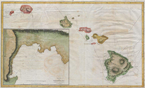
Chart of the Sandwich Islands.
1785 11 x 18.5 in (27.94 x 46.99 cm)
1785 11 x 18.5 in (27.94 x 46.99 cm)
Description
Offered here is an extraordinary and important map of the Hawaiian Islands (Sandwich Islands) printed by G. Nicol and T. Cadell for the 1785 edition of Captain James Cook and James King's, A Voyage to the Pacific Ocean…in the Years 1776, 1777, 1778, 1779, and 1780. Some claim this map was drawn by William Bligh, of Mutiny on the Bounty fame, while he was stationed as midshipman on Cook's fateful third voyage to the South Pacific. Others claim that this map was drawn by Henry Roberts – the Hydrographer of Cook's third expedition. The text of the Third Voyage credits Roberts, however, the British Hydrographical Office copy of the Official Account includes Bligh's journal where he claims to have drawn the maps. In the lower left there is a large inset of Karakakooa Bay and the villages there. It was here that Cook was killed by angry Hawaiians. This map represents a seminal moment in Hawaii cartography and is the basis upon which all subsequent maps of Hawaii were drawn.
Cartographer
Captain James Cook (7 November 1728 - 14 February 1779) is a seminal figure in the history of cartography for which we can offer only a cursory treatment here. Cook began sailing as a teenager in the British Merchant Navy before joining the Royal Navy in 1755. He was posted in America for a time where he worked Samuel Holland, William Bligh, and others in the mapping of the St. Lawrence River and Newfoundland. In 1766 Cook was commissioned to explore the Pacific and given a Captaincy with command of the Endeavour. What followed were three historic voyages of discovery, the highlights of which include the first European contact with eastern Australia, the discovery of the Hawaiian Islands (among many other Polynesian groups), the first circumnavigation of New Zealand, some of the first sightings of Antarctica, the first accurate mapping of the Pacific Northwest, and ultimately his own untimely death at the hands of angry Hawaiians in 1779. The influence of Cook work on the mapping and exploration of the Pacific cannot be understated. More by this mapmaker...
Condition
Very good condition. Narrow margins. Some old repairs/reinforcement. Minor transference. Blank on verso.
References
David, A., The Charts and Coastal Views of Captain Cook's Voyages, 3.81A. Fitzpatrick, G.L., The Early Mapping of Hawai'i, pl. 2.