Digital Image: 1919 H. E. Newton Wall Map of the Hawaiian Islands (Hawaii Territory)
HawaiiLarge-newton-1919_d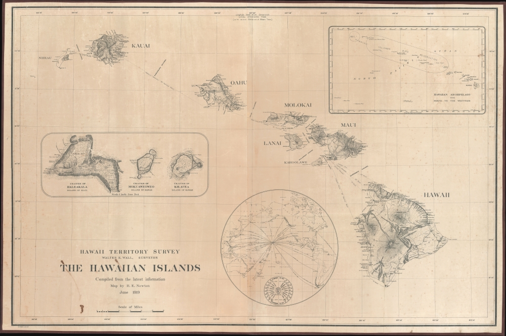

Title
Hawaii Territory Survey. The Hawaiian Islands Compiled from the latest information Map by H. E. Newton June 1919.
1919 (dated) 40 x 60 in (101.6 x 152.4 cm) 1 : 475000
1919 (dated) 40 x 60 in (101.6 x 152.4 cm) 1 : 475000
Description
FOR THE ORIGINAL ANTIQUE MAP, WITH HISTORICAL ANALYSIS, CLICK HERE.
Digital Map Information
Geographicus maintains an archive of high-resolution rare map scans. We scan our maps at 300 DPI or higher, with newer images being 600 DPI, (either TIFF or JPEG, depending on when the scan was done) which is most cases in suitable for enlargement and printing.
Delivery
Once you purchase our digital scan service, you will receive a download link via email - usually within seconds. Digital orders are delivered as ZIP files, an industry standard file compression protocol that any computer should be able to unpack. Some of our files are very large, and can take some time to download. Most files are saved into your computer's 'Downloads' folder. All delivery is electronic. No physical product is shipped.
Credit and Scope of Use
You can use your digial image any way you want! Our digital images are unrestricted by copyright and can be used, modified, and published freely. The textual description that accompanies the original antique map is not included in the sale of digital images and remains protected by copyright. That said, we put significant care and effort into scanning and editing these maps, and we’d appreciate a credit when possible. Should you wish to credit us, please use the following credit line:
Courtesy of Geographicus Rare Antique Maps (https://www.geographicus.com).
How Large Can I Print?
In general, at 300 DPI, you should at least be able to double the size of the actual image, more so with our 600 DPI images. So, if the original was 10 x 12 inches, you can print at 20 x 24 inches, without quality loss. If your display requirements can accommodate some loss in image quality, you can make it even larger. That being said, no quality of scan will allow you to blow up at 10 x 12 inch map to wall size without significant quality loss. For more information, it is best consult a printer or reprographics specialist.
Refunds
If the high resolution image you ordered is unavailable, we will fully refund your purchase. Otherwise, digital images scans are a service, not a tangible product, and cannot be returned or refunded once the download link is used.
Cartographer S
Herbert Ellsworth Newton (September 2, 1882 - January 30, 1963) was a Hawaiian surveyor and engineer. Born in Maui County, Hawaii, Newton attended school in the islands before joining the Hawaiian Territorial Survey as a 'rodman' in November 1900. (Rodmen transport and set up survey equipment and prepare the job site.) He worked for the Hawaiian Territorial Survey for nearly 50 years and was the chief cadastral engineer when he retired on July 1, 1950, at the time the longest continual service with the Hawaii Territorial government. He made the first official map of the Hawaii Territory in 1919. He married Minnie Hutchison in June 1906, and they had three children. More by this mapmaker...
Walter Eugene Wall (October 13, 1867 - July 23, 1944) was an American surveyor. Born in Yreka, California, he arrived in Honolulu with his parents in 1880. His father was the architect in charge of the construction of the Iolani Palace. He began working at the Hawaiian Government Survey in 1889 and was appointed Territorial Surveyor General in 1901. He worked for the survey for more than 35 years. Wall attended the Ponahou School where he was known for his athletics, introducing the curveball (referenced as 'curve pitching in baseball' in his obituary) to Hawaii. He married Edith Louise Dietz on June 22, 1903. He died in 1944 in Honolulu. Learn More...
References
cf. OCLC 133468723 (Half Size Variant).