Digital Image: 1949 Shane / Leno Pictorial Map of Warm Springs Indian Reservation, Oregon
HistoReliefWarmSprings-shane-1949_d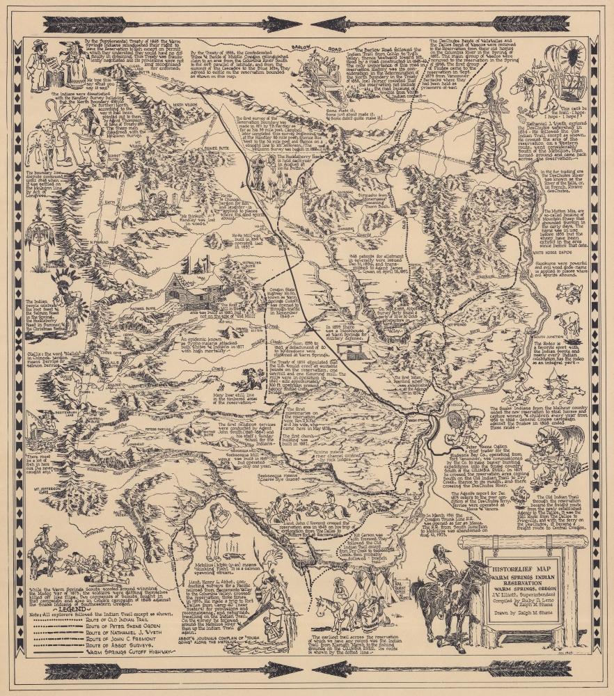

Title
HistoRelief Map of Warm Springs Indian Reservation Warm Springs, Oregon.
1949 (dated) 17.5 x 15.5 in (44.45 x 39.37 cm)
1949 (dated) 17.5 x 15.5 in (44.45 x 39.37 cm)
Description
FOR THE ORIGINAL ANTIQUE MAP, WITH HISTORICAL ANALYSIS, CLICK HERE.
Digital Map Information
Geographicus maintains an archive of high-resolution rare map scans. We scan our maps at 300 DPI or higher, with newer images being 600 DPI, (either TIFF or JPEG, depending on when the scan was done) which is most cases in suitable for enlargement and printing.
Delivery
Once you purchase our digital scan service, you will receive a download link via email - usually within seconds. Digital orders are delivered as ZIP files, an industry standard file compression protocol that any computer should be able to unpack. Some of our files are very large, and can take some time to download. Most files are saved into your computer's 'Downloads' folder. All delivery is electronic. No physical product is shipped.
Credit and Scope of Use
You can use your digial image any way you want! Our digital images are unrestricted by copyright and can be used, modified, and published freely. The textual description that accompanies the original antique map is not included in the sale of digital images and remains protected by copyright. That said, we put significant care and effort into scanning and editing these maps, and we’d appreciate a credit when possible. Should you wish to credit us, please use the following credit line:
Courtesy of Geographicus Rare Antique Maps (https://www.geographicus.com).
How Large Can I Print?
In general, at 300 DPI, you should at least be able to double the size of the actual image, more so with our 600 DPI images. So, if the original was 10 x 12 inches, you can print at 20 x 24 inches, without quality loss. If your display requirements can accommodate some loss in image quality, you can make it even larger. That being said, no quality of scan will allow you to blow up at 10 x 12 inch map to wall size without significant quality loss. For more information, it is best consult a printer or reprographics specialist.
Refunds
If the high resolution image you ordered is unavailable, we will fully refund your purchase. Otherwise, digital images scans are a service, not a tangible product, and cannot be returned or refunded once the download link is used.
Cartographer S
Ralph M. Shane (1910 - July 12, 1984) was an artist and U.S. government engineer. Born near Edelstein, Illinois, Shane's parents moved the family to Pipestone, Minnesota, where he attended public school. After high school, Shane attended the University of Colorado before transferring to the South Dakota School of Mines, where he graduated in 1935 with a B.S. in engineering. He found work with the South Dakota State Highway Commission and drafted strip and right-of-way maps. In November 1936, Shane joined the Bureau of Indian Affairs as an engineering draftsman. He was promoted to junior road engineer the following year. The Bureau transferred him to Sacramento, California, in January 1939 to work as chief of a road survey party. Shane worked as a road engineer for the Bureau of Indian Affairs across the western United States through the 1940s and 1950s, except for a four-month furlough in 1943 when he served as a Navy ensign. He left the Bureau of Indian Affairs in 1955 and bought a newspaper in New Town, North Dakota, which he edited for two years before returning to the Bureau of Indian Affairs. He retired from the Bureau in 1979. Shane was married twice. First to Jeanette Wildman, whom he married in 1936, then to Carolyn Mae Hodgkinson, whom he married on July 14, 1944. He had four children. More by this mapmaker...
Ruby D. Leno (March 5, 1915 - March 13, 1990), née Dean, was an American Indian of the Upper Chinook of the Warm Springs Reservation, Oregon. She was born Grand Ronde, Polk County, Oregon. She worked for the Warm Spring Agency, Field Services. She worked with Indian Agent Ralph M. Shane to compile a historical map of the Warm Spring Reservation. Learn More...
References
Native American Maps Collection (MAPS NativeMaps), Oregon State University Special Collections and Archives Research Center, Corvallis, Oregon.