
This item below is out of stock, but another example (left) is available. To view the available item, click "Details."
Details
1929 Admiralty Nautical Chart or Map of Hong Kong
1929 (dated) $2,000.00
1924 Imperial Japanese Railway Map or Plan of Hong Kong
HongKong-japgovtrail-1924$150.00

Title
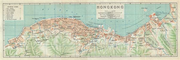
Hong Kong.
1924 (undated) 6 x 17.5 in (15.24 x 44.45 cm) 1 : 17000
1924 (undated) 6 x 17.5 in (15.24 x 44.45 cm) 1 : 17000
Description
This is a beautiful 1924 map of Hong Kong by the Imperial Japanese Government Railways. The map covers the northern part of Hong Kong Island, including Central, Wan Chai and Victoria. This highly detailed map notes streets, individual buildings, government offices, railways and topography. This map was issued as part of the 1924 Official Series Vol. D of the Guide to China and printed at the Toppan Printing Company.
Source
Japanese Government Railways, Guide to China with land and sea routes between the American and European Continents, second (revised) edition, Tokyo, Japan, 1924.
Condition
Very good. Minor wear along fold lines.