1853 Kollner Map of Hopewell, Pennsylvania Coal Deposits w/ Manuscript Annotations
HopewellIronWorks-kollner-1853$800.00

Title
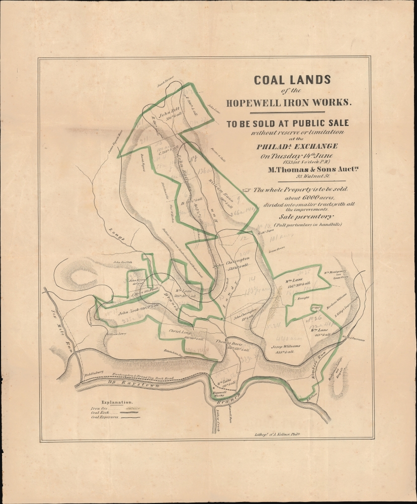
Coal Lands of the Hopewell Iron Works.
1853 (dated) 18.25 x 16.25 in (46.355 x 41.275 cm) 1 : 17000
1853 (dated) 18.25 x 16.25 in (46.355 x 41.275 cm) 1 : 17000
Description
This is an unrecorded and likely unique 1853 promotional broadside with significant manuscript annotations, printed by Augustus Köllner for a land auction held in Philadelphia. The land being sold, located in Bedford County in southern Pennsylvania, was rich in coal deposits and historically supplied the Hopewell Furnace, a legendary American ironworks located in Berks County which supplied cannon and other war materials during American Revolution. By this time, the Hopewell Furnace had long ceased to operate, but its valuable coal-land, as here, took on new significance with the emergence of the Industrial Revolution.
The Huntingdon and Broad Top Mountain Railroad runs along the Raystown Branch of the Juniata at bottom to the iron works. The railroad, only chartered earlier in 1853, was a short line between Huntingdon to Bedford that was primarily meant to provide coal producers an alternative to the Baltimore and Ohio Railroad, which aspired to and nearly achieved a monopoly on coal transport in Pennsylvania.
In relation to the main purpose of the map, local landholders' plots are traced and their names recorded, with owners of the lands being auctioned (traced in green) appearing with the acreage of their lands noted. Handwritten pencil annotations suggest that some plots were subdivided in the course of sale, as the map's subtitle also implies, while the acreage of others may have bene slightly adjusted from the amount originally printed.
A Closer Look
This map, oriented towards the east, portrays an area of Bedford County, Pennsylvania, where coal-rich land was scheduled for a June 15, 1853 public auction. All these lands were associated with the Hopewell Iron Works (Hopewell Furnace, c. 1771). They are, in fact, far west of that site. Settlements, such as Riddlesburg at bottom-left, and other features are labeled. Several waterways are depicted, which are tributaries of the Juniata River, which is itself a tributary of the Susquehanna River. Elevation is indicated by hachure lines, while iron ore and abundant coal deposits are represented according to the legend at bottom-left.The Huntingdon and Broad Top Mountain Railroad runs along the Raystown Branch of the Juniata at bottom to the iron works. The railroad, only chartered earlier in 1853, was a short line between Huntingdon to Bedford that was primarily meant to provide coal producers an alternative to the Baltimore and Ohio Railroad, which aspired to and nearly achieved a monopoly on coal transport in Pennsylvania.
In relation to the main purpose of the map, local landholders' plots are traced and their names recorded, with owners of the lands being auctioned (traced in green) appearing with the acreage of their lands noted. Handwritten pencil annotations suggest that some plots were subdivided in the course of sale, as the map's subtitle also implies, while the acreage of others may have bene slightly adjusted from the amount originally printed.
Pennsylvania Coal and the American Industrial Revolution
This map was produced when the extraction of coal from Pennsylvania's hills and mountains was powering the industrialization of the United States and demand was nearly insatiable, leading to the search for new deposits to exploit. Beginning in the late 18th century, Americans gradually gained a better understanding of the different types and uses of coal and how to best harness them for smelting iron, powering steam engines, and other uses. At the time of this map's production, harder anthracite coal, which burns cleaner, hotter, and for longer than the softer bituminous coal, was in especially high demand. Given the location of Bedford County, the coal in question with this map was very likely bituminous coal, which was easier to mine and more abundant than anthracite, and was used for making coke, an important input for ironworks, explaining the presence here of one such foundry (often called 'plantations' at the time). In later years, the rich deposits of bituminous coal in southwestern Pennsylvania helped the Union side win the U.S. Civil War and then made Pittsburgh into the 'Steel City,' thanks primarily to Carnegie Steel.Publication History and Census
This map was lithographed by Augustus Köllner, based in Philadelphia, in 1853 for M. Thomas and Sons, land auctioneers also based in Philadelphia. We are unaware of any other examples of this map in institutional collections nor any history of it being on the market.Cartographer
Augustus Theodore Frederick Köllner (1812 - December 10, 1906) was an artist, engraver, and lithographer based in Philadelphia. Born in Wurttemberg, Germany, Köllner began his career in Germany, working as a book illustrator in Stuttgart and Paris in the late 1820s and 1830s before immigrating to the United States in 1839. After settling in Washington, D.C., Köllner worked as a lithographer for the Haas firm, working on advertisements, bank notes, and city views. He moved to Philadelphia in 1840 and tried unsuccessfully to establish himself as a portrait painter. After this misstep, Köllner became the second chief artist of P.S. Duval and William Huddy's 'U.S. Military Magazine' (1839 - 1842). Throughout the 1840s, Köllner worked as a lithographer for many different Philadelphia based lithographic firms, including Duval, J.T. Bowen, Frederick Kuhl, Thomas Sinclair, and Wagner and McGuigan. Between 1847 and 1848, Köllner began working for the lithographic firm Brechemin and Camp, for whom he designed all genres of lithographs and advertised his own lithographic views based on his annual summer sketching trips along the East Coast. His work also began to be published in the seminal series 'View of American Cities', published between 1848 and 1851 by Goupil, Vibert, and Company. While working for Brechemin and Camp, Köllner was responsible for creating the multi-foot Dripp's map of New York City. Kollner established his own firm in 1851 and worked on a wide range of projects, including advertisements, labels, city and landscape views, and maps. During the Civil War, Köllner enlisted in the cavalry in 1863 and later sold photographic reproductions of the etchings he did as a soldier. He produced his last series of landscape lithographs entitled 'Bits of Nature' in 1878, but focused mostly on his watercolor work during the late 1870s. Köllner retired in the early 1880s, but continued to make sketching trips around the Philadelphia area. Köllner married Mary Sheek (c. 1821 - 1899) in 1843, and they had several children, three of which survived infancy: William, Clara, and Josephine. Köllner died on December 10, 1906. More by this mapmaker...
Condition
Good. Some discoloration. Edgewear. Slight loss at 2 fold intersections, stabilized on verso.