This item has been sold, but you can get on the Waitlist to be notified if another example becomes available, or purchase a digital scan.
1870 Colton Railroad Map of New York, Pennsylvania, New England, New Jersey
HudsonRiverBridge-colton-1870$375.00

Title
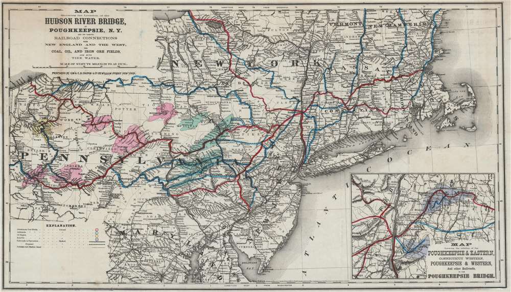
Map Showing the Location of the Hudson River Bridge at Poughkeepsie, N.Y. and its Various Railroad Connections with New England and the West, the Coal, Oil, and Iron Ore Fields, and with Tide Water.
1870 (dated) 16.25 x 28.75 in (41.275 x 73.025 cm) 1 : 1267000
1870 (dated) 16.25 x 28.75 in (41.275 x 73.025 cm) 1 : 1267000
Description
This is an 1870 George Woolworth and Charles B. Colton map of the northeast United States created to promote the construction of a Hudson River railroad bridge at Poughkeepsie, New York. Depicting the region from Erie, Pennsylvania to the Atlantic Ocean and from Oswego, New York to Washington, D.C., with a focus on the railroad network. Numerous regional railroad lines are illustrated, including the Hudson River Railroad, the Lackawanna and Bloomsburg Railroad, and the New Haven, Hartfield, and Springfield Railroad. Cities and towns along the routes are labeled, and distances provided. Proposed railroads are also included as dashed lines. An inset in the lower right focuses on the area immediately surrounding Poughkeepsie and the proposed bridge. The whole emphasizes the point that a bridge at Poughkeepsie would create a relatively straight journey from the coal fields in Pennsylvania to the urban centers of the East Coast. Here, the bituminous coal fields are shaded pink, the anthracite fields green. The oil region in western Pennsylvania is yellow and the iron ore regions around Poughkeepsie are purple.
The Poughkeepsie Railway Bridge
Until the bridge at Poughkeepsie was built, there was no a bridge spanning the Hudson between Albany and New York City. Ferries and steamboats made the crossing at a handful of locations, but that forced railroads to unload their cargo and load it on a ferry, or simply embark the entire cars, to cross the river, which made the river crossing dependent upon the weather. The railroad bridge at Poughkeepsie was first proposed in 1868 in a letter published in the Poughkeepsie Eagle. At the time, the idea appeared so preposterous that the paper ridiculed it and thus the proposal was forgotten. It resurfaced in June 1871 when the Poughkeepsie Bridge Company was chartered. This company contracted with the American Bridge Company (not the same firm as the more famous later one), but the whole idea collapsed under the pressure of the Panic of 1873. Then, in 1886, the Manhattan Bridge Building Company was created to finance the project and contracted the United Bridge Company, who had recently completed the Niagara Cantilever Bridge, to build the one at Poughkeepsie. It was completed in 1888, and the first train crossed on December 29 of that year. The bridge opened for passenger service on January 1, 1889.Publication History and Census
This map was created by George Woolworth and Charles B. Colton in 1870 and published by the Poughkeepsie Railroad Company in a booklet entitled Bridging the Hudson at Poughkeepsie, for a Short Direct Line, from New England to the Could Fields and From the West and the East for an all Rail Route, Saving from Eighty to One-Hundred Miles in Distance in 1871. One example is recorded in the OCLC and is part of the collection at the University of California Berkeley.Cartographer
Joseph Hutchins Colton (July 5, 1800 - July 29, 1893), often publishing as J. H. Colton, was an important American map and atlas publisher active from 1833 to 1897. Colton's firm arose from humble beginnings when he moved to New York in 1831 and befriended the established engraver, Samuel Stiles. He worked under Stiles as the 'Co.' in Stiles and Co. from 1833 to 1836. Colton quickly recognized an emerging market in railroad maps and immigrant guides. Not a cartographer or engraver himself, Colton's initial business practice mostly involved purchasing the copyrights of other cartographers, most notably David H. Burr, and reissuing them with updated engraving and border work. His first maps, produced in 1833, were based on earlier Burr maps and depicted New York State and New York City. Between 1833 and 1855, Colton proceeded to publish a large corpus of guidebooks and railroad maps, which proved popular. In the early 1850s, Colton brought his two sons, George Woolworth Colton (1827 - 1901) and Charles B. Colton (1832 - 1916), into the map business. G. W. Colton, trained as a cartographer and engraver, was particularly inspired by the idea of creating a large and detailed world atlas to compete with established European firms for the U.S. market. In 1855, G.W. Colton issued volume one of the impressive two-volume Colton's Atlas of the World. Volume two followed a year later. Possibly because of the expense of purchasing a two-volume atlas set, the sales of the Atlas of the World did not meet Colton's expectations, and so, in 1856, the firm also issued the atlas as a single volume. The maps contained in this superb work were all original engravings, and most bear an 1855 copyright. All of the maps were surrounded by an attractive spiral motif border that would become a hallmark of Colton's atlas maps well into the 1880s. In 1857, the slightly smaller Colton's General Atlas replaced the Atlas of the World. Most early editions of the General Atlas published from 1857 to 1859 do not have the trademark Colton spiral border, which was removed to allow the maps to fit into a smaller format volume. Their customers must have missed the border because it was reinstated in 1860 and remained in all subsequent publications of the atlas. There were also darker times ahead; in 1858, Colton was commissioned at a sum of 25,000 USD by the government of Bolivia to produce and deliver 10,000 copies of a large format map of that country. Although Colton completed the contract in good faith, delivering the maps at his own expense, he was never paid by Bolivia, which was at the time in the midst of a series of national revolutions. Colton would spend the remainder of his days fighting with the Bolivian and Peruvian governments over this payment, and in the end, after a congressional intervention, he received as much as 100,000 USD in compensation. Nonetheless, at the time, it was a disastrous blow. J. H. Colton and Company is listed as one of New York's failed companies in the postal record of 1859. This led Colton into the arms of Alvin Jewett Johnson and Ross C. Browning. The 1859 edition of Colton's General Atlas lists Johnson and Browning as the 'Successor's to J. H. Colton' suggesting an outright buyout, but given that both companies continued to publish separately, the reality is likely more complex. Whatever the case may have been, this arrangement gave Johnson and Browning access to many of Colton's map plates and gave birth to Johnson's New Illustrated (Steel Plate) Family Atlas. The Johnson's Atlas was published parallel to Colton's atlases well into the 1880s. The Colton firm itself subsequently published several other atlases including an Atlas of America, the Illustrated Cabinet Atlas, the Octavo Atlas of the Union, and Colton's Quarto Atlas of the World. They also published a large corpus of wall maps, pocket maps, and guides. The last known publications of the Colton firm date to 1897 and include a map and a view, both issued in association with the Merchant's Association of New York. Alice M. Colton married August R. Ohman (May 3, 1859 - April 22, 1934) on January 5, 1897. In 1898, Ohman joined the Colton firm, which continued to publish as Colton, Ohman & Co. until 1901. More by this mapmaker...
Source
Poughkeepsie Bridge Company, Bridging the Hudson at Poughkeepsie, for a Short Direct Line, from New England to the Could Fields and From the West and the East for an all Rail Route, Saving from Eighty to One-Hundred Miles in Distance, (Poughkeepsie, N.Y.: Poughkeespie Bridge Company) 1871.
Condition
Good. Left margin reinstated at insertion point. Closed margin tears professionally repaired on verso. Light wear along original fold lines. Exhibits some soiling. Blank on verso.
References
OCLC 227480067.