Digital Image: 1946 McGregor Hurricane Map of the Caribbean Sea and the Eastern United States
HurricaneMap-mcgregor-1946_d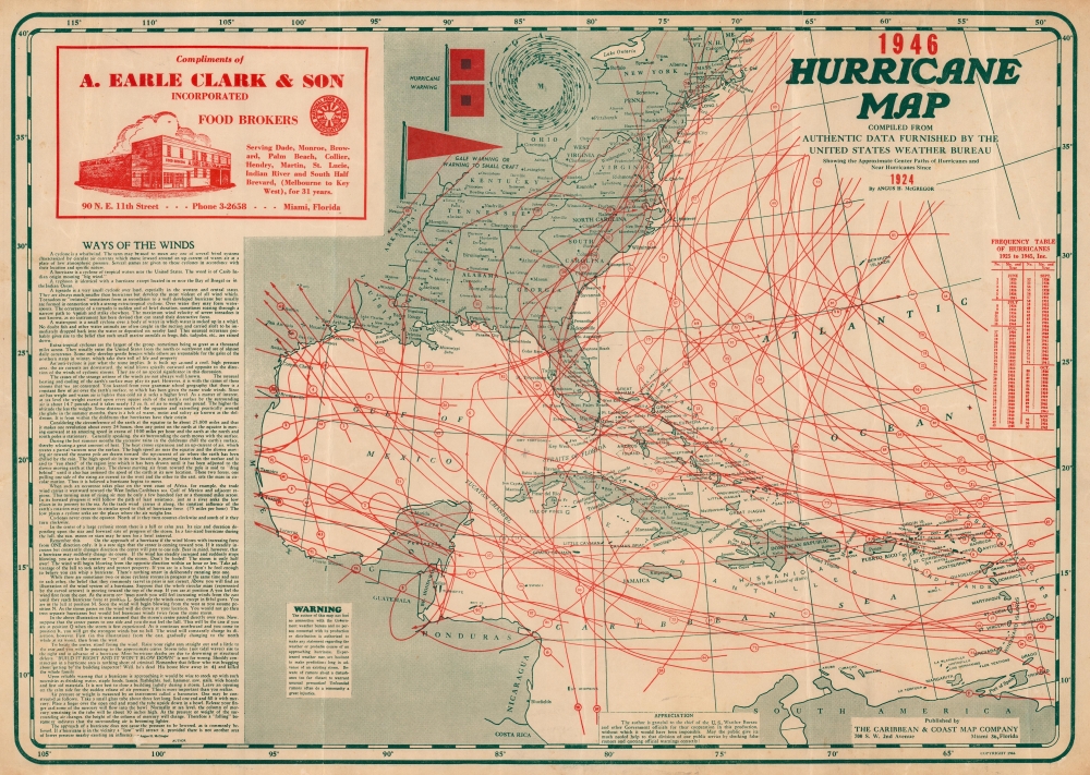

Title
Hurricane Map 1946. Compiled from Authentic Data Furnished by the United States Weather Bureau Showing the Approximate Center Paths of Hurricanes and Near Hurricanes since 1924.
1946 (dated) 14.5 x 20.5 in (36.83 x 52.07 cm) 1 : 11000000
1946 (dated) 14.5 x 20.5 in (36.83 x 52.07 cm) 1 : 11000000
Description
FOR THE ORIGINAL ANTIQUE MAP, WITH HISTORICAL ANALYSIS, CLICK HERE.
Digital Map Information
Geographicus maintains an archive of high-resolution rare map scans. We scan our maps at 300 DPI or higher, with newer images being 600 DPI, (either TIFF or JPEG, depending on when the scan was done) which is most cases in suitable for enlargement and printing.
Delivery
Once you purchase our digital scan service, you will receive a download link via email - usually within seconds. Digital orders are delivered as ZIP files, an industry standard file compression protocol that any computer should be able to unpack. Some of our files are very large, and can take some time to download. Most files are saved into your computer's 'Downloads' folder. All delivery is electronic. No physical product is shipped.
Credit and Scope of Use
You can use your digial image any way you want! Our digital images are unrestricted by copyright and can be used, modified, and published freely. The textual description that accompanies the original antique map is not included in the sale of digital images and remains protected by copyright. That said, we put significant care and effort into scanning and editing these maps, and we’d appreciate a credit when possible. Should you wish to credit us, please use the following credit line:
Courtesy of Geographicus Rare Antique Maps (https://www.geographicus.com).
How Large Can I Print?
In general, at 300 DPI, you should at least be able to double the size of the actual image, more so with our 600 DPI images. So, if the original was 10 x 12 inches, you can print at 20 x 24 inches, without quality loss. If your display requirements can accommodate some loss in image quality, you can make it even larger. That being said, no quality of scan will allow you to blow up at 10 x 12 inch map to wall size without significant quality loss. For more information, it is best consult a printer or reprographics specialist.
Refunds
If the high resolution image you ordered is unavailable, we will fully refund your purchase. Otherwise, digital images scans are a service, not a tangible product, and cannot be returned or refunded once the download link is used.
Cartographer
Angus Harris McGregor (January 16, 1901 - September 24, 1977) was an American engineer, cartographer, and inventor. Born in Melrose, Florida, McGregor lived his most of his adult life in Miami, Florida. He began issuing hurricane maps of the southeastern United States and the Caribbean in 1931 and issued new editions annually, using dashed and dotted lines to track the paths of the storms. He sold the maps to undertakers, insurance companies, roofing companies, and other related businesses for distribution. In 1939, after a New England hurricane, companies in New England requested copies of his map, and that year he expanded the map's coverage area to include from Canada to northern South America. McGregor also created the official Miami-Dade County precinct map published in 1934. McGregor published editions of his hurricane map through at least 1964. On October 28, 1940, McGregor was injured in a railroad accident when a switch engine struck his car at N.W. Seventh Avenue and 73rd Street in Miami. He suffered head, leg, chest, and internal injuries and sued the Florida East Coast Railway claiming permanent disability. A jury awarded him $22,500 in June 1942. On his World War II draft card, completed in February 1942, he included under 'obvious physical characteristics', 'left eye artificial, scar right forehead, right leg partially paralyzed'. More by this mapmaker...