This item has been sold, but you can get on the Waitlist to be notified if another example becomes available, or purchase a digital scan.
1861 Colton Railroad Map of Illinois (scarce 1861 first state)
Illinois-colton-1861$500.00

Title
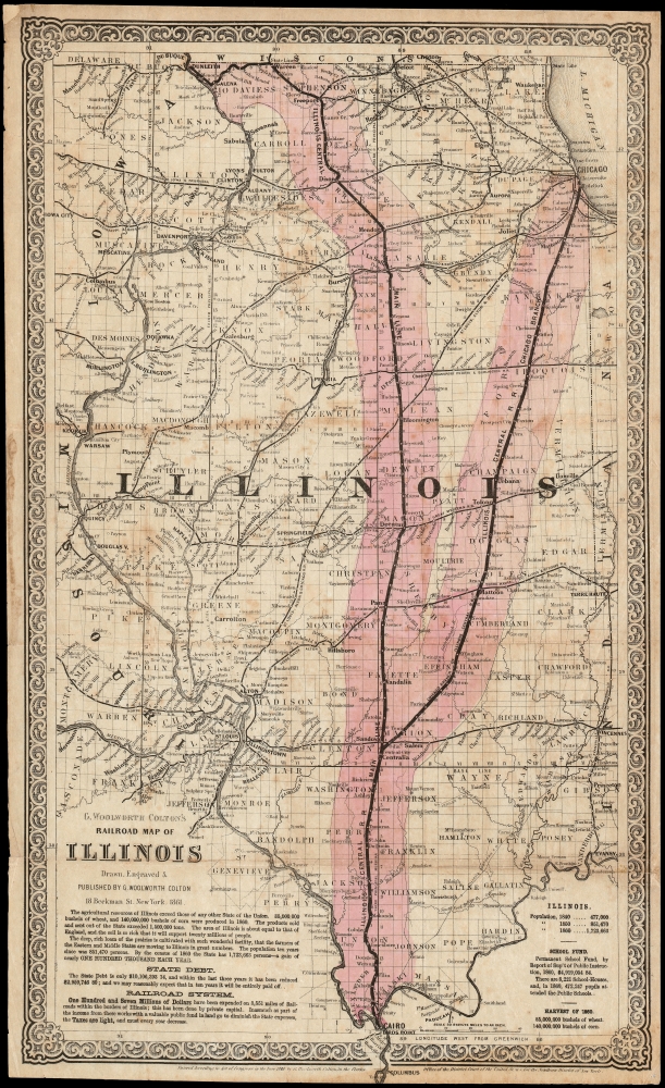
G. Woolworth Colton's Railroad Map of Illinois.
1861 (dated) 20.25 x 12 in (51.435 x 30.48 cm) 1 : 1267200
1861 (dated) 20.25 x 12 in (51.435 x 30.48 cm) 1 : 1267200
Description
This is a scarce, separately issued first edition of G. W. Colton's 1861 map of Illinois, produced for the Illinois Central Railroad to promote land sales. Rare in any edition, this the first known state of the map, identified by the absence sales statistics appearing in subsequent printings. Dominating the map and spanning the state from north to the south are the Main Line and the Chicago Branch of the Illinois Central Railroad, and the thirty-mile-wide corridors of land granted by the Federal government for the construction of the railroad (highlighted in pink.)
The Illinois Central Railroad
This was the first land grant railroad in the United States, supported by such varied personages as Senator Stephen A. Douglas and the future President Abraham Lincoln, who was on retainer as the railroad's lawyer in the years prior to his Presidency. Despite being incorporated in 1836, the Federal land grant permitting the construction was not approved until 1850. The railroad was subsequently chartered in 1851 and, at the time of its completion in 1856, it was the longest railroad in the world. To repay investors, the railroad sold the excess grant lands abutting its lines. The present map marks lands for sale in pink, underscoring the vast land-weath and power of the railoads.Also Promoting Illinois
The state, by any standard, was experiencing a boom - a fact stressed on the map, no doubt as an appeal to investors. The state's agricultural production, its exports, its abundant space, and the richness of its soil are offered as evidence. Population figures from 1840 to 1850 nearly double, and more than double again in the next decade: 'a gain of nearly one hundred thousand each year'. The state's school fund, too, is boasted of, underscoring that the state's citizenry would be well educated.Publication History and Census
This map was printed in 1861, sold separately as a folding map. As such, the map is markedly scarcer than Colton's comparatively ubiquitous atlas maps. Only three examples are cataloged in OCLC, listed by the Library of Congress, Pennsylvania State University, and the University of Michigan. Of these we can only confirm that the LOC copy is the same, 1861 first edition first state: the Pennsylvania and Michigan copies may be later states. This presently offered example is an extremely early version of the map: later states include a table in the lower right noting acreage of the land actually sold. The present example, as with that held by the Library of Congress, lacks this table (instead reiterating the harvest of wheat and corn for 1860). We are aware of at least two other, later states of this map: one including the land sales for 1861, 62, 63, and 64; a further for 1865.Cartographer
Joseph Hutchins Colton (July 5, 1800 - July 29, 1893), often publishing as J. H. Colton, was an important American map and atlas publisher active from 1833 to 1897. Colton's firm arose from humble beginnings when he moved to New York in 1831 and befriended the established engraver, Samuel Stiles. He worked under Stiles as the 'Co.' in Stiles and Co. from 1833 to 1836. Colton quickly recognized an emerging market in railroad maps and immigrant guides. Not a cartographer or engraver himself, Colton's initial business practice mostly involved purchasing the copyrights of other cartographers, most notably David H. Burr, and reissuing them with updated engraving and border work. His first maps, produced in 1833, were based on earlier Burr maps and depicted New York State and New York City. Between 1833 and 1855, Colton proceeded to publish a large corpus of guidebooks and railroad maps, which proved popular. In the early 1850s, Colton brought his two sons, George Woolworth Colton (1827 - 1901) and Charles B. Colton (1832 - 1916), into the map business. G. W. Colton, trained as a cartographer and engraver, was particularly inspired by the idea of creating a large and detailed world atlas to compete with established European firms for the U.S. market. In 1855, G.W. Colton issued volume one of the impressive two-volume Colton's Atlas of the World. Volume two followed a year later. Possibly because of the expense of purchasing a two-volume atlas set, the sales of the Atlas of the World did not meet Colton's expectations, and so, in 1856, the firm also issued the atlas as a single volume. The maps contained in this superb work were all original engravings, and most bear an 1855 copyright. All of the maps were surrounded by an attractive spiral motif border that would become a hallmark of Colton's atlas maps well into the 1880s. In 1857, the slightly smaller Colton's General Atlas replaced the Atlas of the World. Most early editions of the General Atlas published from 1857 to 1859 do not have the trademark Colton spiral border, which was removed to allow the maps to fit into a smaller format volume. Their customers must have missed the border because it was reinstated in 1860 and remained in all subsequent publications of the atlas. There were also darker times ahead; in 1858, Colton was commissioned at a sum of 25,000 USD by the government of Bolivia to produce and deliver 10,000 copies of a large format map of that country. Although Colton completed the contract in good faith, delivering the maps at his own expense, he was never paid by Bolivia, which was at the time in the midst of a series of national revolutions. Colton would spend the remainder of his days fighting with the Bolivian and Peruvian governments over this payment, and in the end, after a congressional intervention, he received as much as 100,000 USD in compensation. Nonetheless, at the time, it was a disastrous blow. J. H. Colton and Company is listed as one of New York's failed companies in the postal record of 1859. This led Colton into the arms of Alvin Jewett Johnson and Ross C. Browning. The 1859 edition of Colton's General Atlas lists Johnson and Browning as the 'Successor's to J. H. Colton' suggesting an outright buyout, but given that both companies continued to publish separately, the reality is likely more complex. Whatever the case may have been, this arrangement gave Johnson and Browning access to many of Colton's map plates and gave birth to Johnson's New Illustrated (Steel Plate) Family Atlas. The Johnson's Atlas was published parallel to Colton's atlases well into the 1880s. The Colton firm itself subsequently published several other atlases including an Atlas of America, the Illustrated Cabinet Atlas, the Octavo Atlas of the Union, and Colton's Quarto Atlas of the World. They also published a large corpus of wall maps, pocket maps, and guides. The last known publications of the Colton firm date to 1897 and include a map and a view, both issued in association with the Merchant's Association of New York. Alice M. Colton married August R. Ohman (May 3, 1859 - April 22, 1934) on January 5, 1897. In 1898, Ohman joined the Colton firm, which continued to publish as Colton, Ohman & Co. until 1901. More by this mapmaker...
Condition
Good. Marginal mends just impacting border with no loss to image; recornered in upper left not touching image. Some staining and toning. Else very good with original wash color.
References
OCLC 43787905.