1849 Greenleaf Map of Illinois
Illinois-greenleaf-1849$350.00

Title
Illinois.
1849 (undated) 12.75 x 10.75 in (32.385 x 27.305 cm) 1 : 1975000
1849 (undated) 12.75 x 10.75 in (32.385 x 27.305 cm) 1 : 1975000
Description
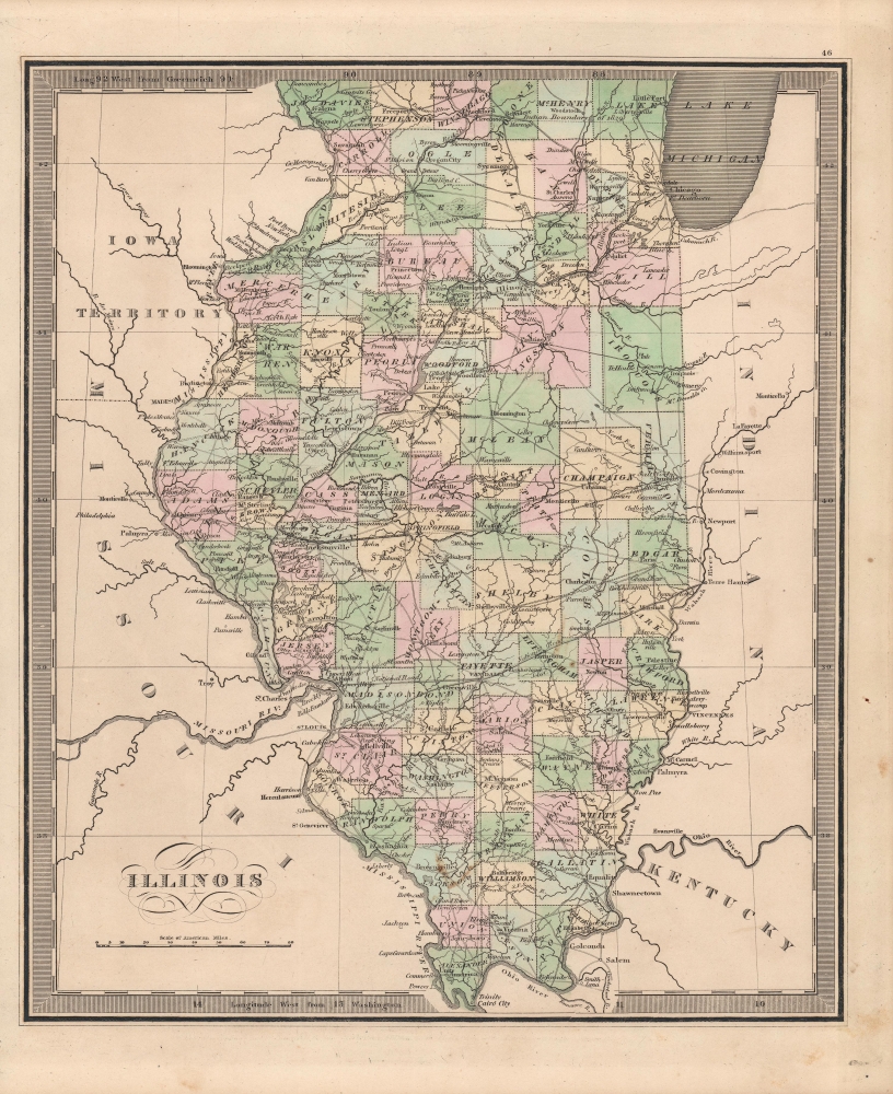
This is Jeremiah Greenleaf's 1849 map of Illinois. It appeared in his Universal Atlas and is notable for its level of detail.
Just north of Chicago is a dotted line 'Indian Boundary of 1829,' which replaced an earlier Indian Boundary established in 1816. Both boundaries were quickly violated by White settlers. Tensions between the settlers and Native Americans also led to the establishment of fortified trading posts, including Little Fort, north of Chicago in Lake County along the shores of Lake Michigan.
The oddly-shaped Vermillion County seen here in the state's east was divided in 1859, creating Ford County, on account of the distance required to travel between different sides of the county (especially the long travel from the county's north to its seat at Danville).
A Closer Look
The state of Illinois is displayed with counties shaded different colors for easy differentiation. Settlements, waterways (including canals), roads, swamps, and more are indicated throughout in great detail. The state's first railroad, the Northern Cross Railroad, only opened the previous year, is seen connecting Meredosia with Springfield. Chicago, only chartered two years earlier but growing quickly at this time, is seen at top-right.Just north of Chicago is a dotted line 'Indian Boundary of 1829,' which replaced an earlier Indian Boundary established in 1816. Both boundaries were quickly violated by White settlers. Tensions between the settlers and Native Americans also led to the establishment of fortified trading posts, including Little Fort, north of Chicago in Lake County along the shores of Lake Michigan.
The oddly-shaped Vermillion County seen here in the state's east was divided in 1859, creating Ford County, on account of the distance required to travel between different sides of the county (especially the long travel from the county's north to its seat at Danville).
Publication History and Census
This map is a much-revised Greenleaf issue of David Hugh Burr's 1834 map of the same. The Burr map plates fell into the hands of Jeremiah Greenleaf, who revised them for publication in his own Universal Atlas. The present example is from the 1849 edition of the atlas, the last and final, which was extensively revised over the 1848 edition. We note an example in the David Rumsey Map collection, which has been populated digitally throughout OCLC, making a comprehensive survey of existing physical examples nearly impossible. Nonetheless, the 1849 edition of the atlas is rare, which Rumsey correctly notes is not in Karpinski. We do note an example, however, in Phillips.CartographerS
Jeremiah Greenleaf (1791 - 1864) is a little known but highly admired American cartographer of the early 19th century. He published from roughly 1830 to 1850. His most important work is A New Universal Atlas; Comprising of all the Principal Empires, Kingdoms, and States Throughout the World and Forming a distinct Atlas of the United States, published in several editions in the 1840s. Many of his maps are reformatted versions of his contemporary David Burr's much admired cartographic works. Greenleaf's maps are extremely rare and admired for their stunningly vivid pastel color washes. More by this mapmaker...
David Hugh Burr (August 18, 1803 - December 25, 1875) of one of the first and most important truly American cartographers and map publishers. Burr was born in Bridgeport Connecticut in August of 1803. In 1822 Burr moved to Kingsboro, New York to study law. A year and a half later he was admitted to the New York Bar association. Burr must have questioned his choice of careers because shortly after being admitted to the Bar, he joined the New York State Militia. Though largely untrained in the art of surveying, Burr was assigned to work under Surveyor General of New York, Simeon De Witt, to survey several New York Roadways. Seeing a window of opportunity, Burr was able to negotiate with the governor of New York at the time, De Witt Clinton, to obtain copies of other New York survey work in order to compile a map and Atlas of the state of New York. Recognizing the need for quality survey work of its territory, the government of New York heartily endorsed and financed Burr's efforts. The resulting 1829 Atlas of the State of New York was the second atlas of an individual U.S. state and one of the most important state atlases ever produced. Burr went on to issue other maps both of New York and of the United States in general. In cooperation with publishing firm of Illman & Pillbrow, he produced an important New Universal Atlas and, with J.H. Colton, several very important maps of New York City. In recognition of this work, Burr was appointed both "Topographer to the Post office" and "Geographer to the House of Representatives of the United States". Later, in 1855, Burr was assigned to the newly created position of Surveyor General to the State of Utah. Burr retired from the position and from cartographic work in general in 1857 when light of some of his financial misdeeds and frauds came to light. He was accused of submitting false expense reports and underpaying employees, among other indiscretions. Learn More...
Source
Greenleaf, J., New Universal Atlas, (Brattleboro, Vermont: Greenleaf) 1849.
Condition
Very good. Even overall toning. Minor imperfections, mostly confined to margins.
References
Rumsey 15176.050.