This item has been sold, but you can get on the Waitlist to be notified if another example becomes available, or purchase a digital scan.
1655 Blaeu Map of China, Japan, and Korea
ImperiiSinarum-blaeu-1655$600.00

Title
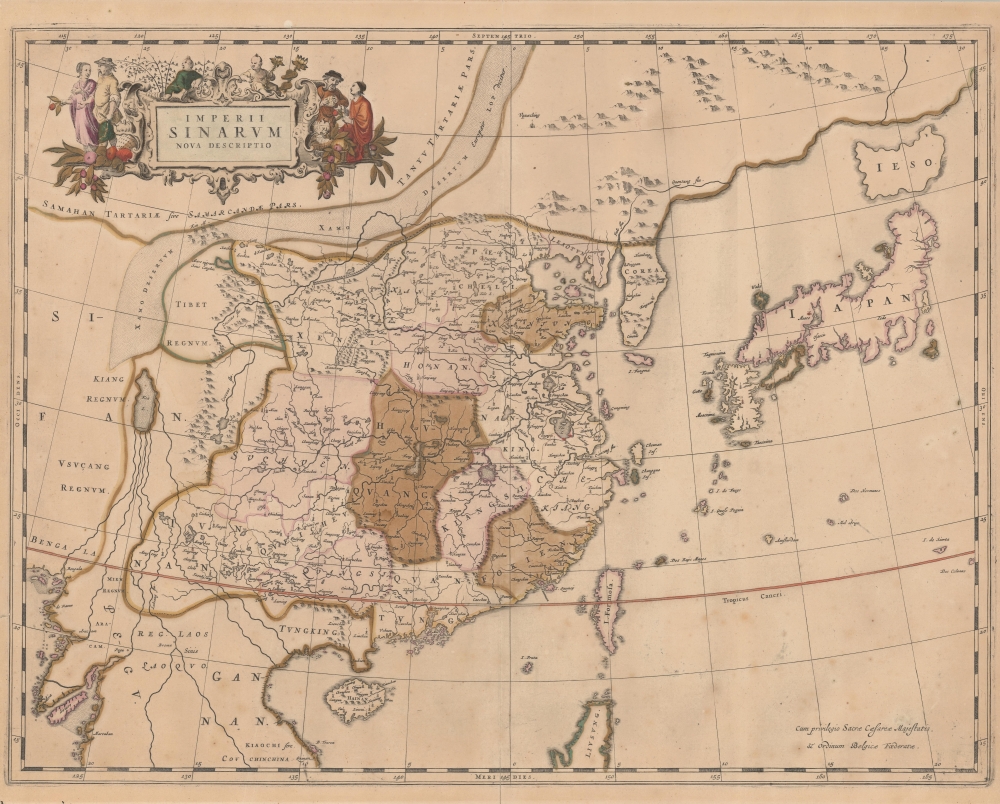
Imperii Sinarum Nova Descriptio.
1655 (undated) 19.25 x 24 in (48.895 x 60.96 cm) 1 : 9400000
1655 (undated) 19.25 x 24 in (48.895 x 60.96 cm) 1 : 9400000
Description
This is the 1655 edition of Martino Martini and Johannes Blaeu's seminal map of China, Japan, and Korea, with fine old color. This is among the most important and influential maps of China issued in the 17th century, being the first publication of Martino Martini's revolutionary geographical data, brought to Europe just months earlier.
The map, combined with Martini's first-hand descriptions of Chinese geography, acquired after 9 years traveling, living, and ministering in China, marks a sea-change in western cartographic perceptions of the Far East. Many earlier mistakes are rectified: Korea (Corea) appears as a peninsula, Hokkaido (Ieso) is an island, and Honshu and Formosa are recognizable. Within China, the Great Wall appears with greater precision than any earlier map, and a distinct provincial system and riverine geography are clearly defined. The map proved so significant an improvement upon earlier works that it was not superseded until the 1695 maps of Vincenzo Coronelli.
Martini's Mapping of China
The revolutionary geography of this map is based on Martini's copy and translation of the Lo Hongxian's (羅洪先; 1504 - 1564) 1555 revision of Zhu Siben's (朱思本;1273 - 1333) 1312 manuscript atlas of the Chinese Provinces, the Guang Yu Tu (廣與圖; 'Enlarged Territorial Atlas'). The translation accompanied him when he set out on a Portuguese ship from Macau to Lisbon, from which he intended to return to Rome. En route, he was captured by the Dutch East India Company (VOC), who instead redirected him to Amsterdam, where he arrived in 1554. The novel cartographic data was immediately seized upon by the Johannes Blaeu firm, who had deep connections with the VOC.The map, combined with Martini's first-hand descriptions of Chinese geography, acquired after 9 years traveling, living, and ministering in China, marks a sea-change in western cartographic perceptions of the Far East. Many earlier mistakes are rectified: Korea (Corea) appears as a peninsula, Hokkaido (Ieso) is an island, and Honshu and Formosa are recognizable. Within China, the Great Wall appears with greater precision than any earlier map, and a distinct provincial system and riverine geography are clearly defined. The map proved so significant an improvement upon earlier works that it was not superseded until the 1695 maps of Vincenzo Coronelli.
A Closer Look
Coverage embraces from the Bay of Bangkok to Hokkaido, and from the Gobi Desert to modern-day Vietnam and northern Luzon (Philippines). The focus is on China, Korea, and Japan, all of which here present novel new detail not seen previously on a European map. Nonetheless, the cartographer is not immune to errors in of the previous generations so in the periphery, we see such anomalies as the mythical Lake of Chiamay.Apocryphal Lake Chiamay
The mythical Lake of Chiamay, or Chiang Mai, appears at the western extreme of the map. Early cartographers postulated that such a lake must exist to source the four important Southeast Asian river systems: the Irrawaddy, the Dharla, the Chao Phraya, and the Brahmaputra. This lake began to appear in maps of Asia as early as the 16th century and persisted well into the mid-18th century. Its origins are unknown but may originate in a lost 16th century geography prepared by the Portuguese scholar Joao de Barros. It was also heavily discussed in the journals of Sven Hedin, who believed it to be associated with Indian legend that a sacred lake, Mansarovar, linked several of the holy subcontinent river systems. There are even records that the King of Siam led an invasionary force to take control of the lake in the 16th century. Nonetheless, the theory of Lake Chiamay was ultimately disproved, and it disappeared from maps entirely by the 1760s.Publication History and Census
This map was compiled, engraved, and printed in 1655 by Johannes Blaeu for Martino Martini's Atlas Sinensis, the first western atlas of China. It appeared in several subsequent atlases and publications, but we see no plate changes, so there is only one state. The present example, although backed on linen by the original binder, is blank on the verso, marking it as one of the 1655 printings. The map is well represented instructionally but is increasingly scarce on the private market.CartographerS
Joan (Johannes) Blaeu (September 23, 1596 - December 21, 1673) was a Dutch cartographer active in the 17th century. Joan was the son of Willem Janszoon Blaeu, founder of the Blaeu firm. Like his father Willem, Johannes was born in Alkmaar, North Holland. He studied Law, attaining a doctorate, before moving to Amsterdam to join the family mapmaking business. In 1633, Willem arranged for Johannes to take over Hessel Gerritsz's position as the official chartmaker of the Dutch East India Company, although little is known of his work for that organization, which was by contract and oath secretive. What is known is his work supplying the fabulously wealthy VOC with charts was exceedingly profitable. Where other cartographers often fell into financial ruin, the Blaeu firm thrived. It was most likely those profits that allowed the firm to publish the Theatrum Orbis Terrarum, sive, Atlas Novus, their most significant and best-known publication. When Willem Blaeu died in 1638, Johannes, along with his brother Cornelius Blaeu (1616 - 1648) took over the management of the Blaeu firm. In 1662, Joan and Cornelius produced a vastly expanded and updated work, the Atlas Maior, whose handful of editions ranged from 9 to an astonishing 12 volumes. Under the brothers' capable management, the firm continued to prosper until the 1672 Great Amsterdam Fire destroyed their offices and most of their printing plates. Johannes Blaeu, witnessing the destruction of his life's work, died in despondence the following year. He is buried in the Dutch Reformist cemetery of Westerkerk. Johannes Blaeu was survived by his son, also Johannes but commonly called Joan II, who inherited the family's VOC contract, for whom he compiled maps until 1712. More by this mapmaker...
Martino Martini (September 20, 1614 - June 6, 1661) was an Italian Jesuit missionary, historian, and cartographer, working mainly on ancient Imperial China. He is acclaimed as the father of Chinese geographical science, as he was ‘the first to study the history and geography of China with rigorous scientific objectivity.' Born in Trento, in the Bishopric of Trent, he finished school in 1631. After, he entered the Society of Jesus and was sent to study classical letters and philosophy at the Roman College, Rome, from 1634 until 1637. He completed his theological studies in Portugal from 1637 until 1639 and was ordained as a priest in Lisbon in 1639. He left for China in 1640, arriving in 1642 in Portuguese Macau. He studied Chinese before, in 1642, moving to Hangzhou, Zhejiang Province. He spent much of his time traveling and gathering scientific information, particularly concerning the geography. In April 1644, soon after his arrival in China, the Ming capital Beijing fell to Li Zicheng’s rebels and then to the Manchus. Martini had been allied with the short-lived regime of Zhu Yujian, Prince of Tang, who declared himself the (Southern) Ming Longwu Emperor after the fall of the last legitimate Ming, the Chongzhen Emperor. When Wenzhou, where Martini was on a mission for Zhu Yujian, was about to fall to the Manchus, Martini convinced them to allow him to change sides. Before the Manchu troops entered the city, Martini created a large red poster stating, 'Here lives a doctor of the divine Law who has come from the Great West.' Below the poster he arranged tables with European books, astronomical instruments, and other objects surrounding an altar with an image of Jesus. The commander of the Manchu troops was so impressed by the display that he politely asked Martini to change sides. In 1651, Martini left China as the Delegate of the Chinese Mission Superior. Among the works he brought with him was Lo Hongxian's (羅洪先; 1504 - 1564) 1555 revision of Zhu Siben's (朱思本;1273 - 1333) 1312 manuscript atlas of the Chinese Provinces, Guang Yu Tu (廣與圖; 'Enlarged Territorial Atlas'). En route, his ship was captured by the Dutch, who apparently also saw Martini's value: they took him first to Java, and then to Amsterdam, where he arrived in 1654. During this intervening period, Martini translated the Zhu Siben atlas into Latin, and added his own description of China. The Blaeu mapmaking firm swiftly published Martini's map as Novus Atlas Sinensis, and later published Martini's description of China both on its own and within the Blaeu Atlas. After his circuitous journey, he reached Rome in the spring of 1655. He carried with him a long and detailed communication from the Jesuit missionaries in China, defending the so-called Chinese Rights (veneration of ancestors and other practices allowed to new Christians). After five months of discussions and debates, the Propaganda Fide issued a degree in favor of the Jesuits, although the controversy did not abate. Learn More...
Source
Martini, Martino, Novus Atlas Sinensis, (Amsterdam: Blaeu) 1655.
Martino Martini's Novus Atlas Sinensis, published by the Blaeu firm in 1655, was the first atlas and geography of China published in Europe. Consisting of 17 maps, it is noteworthy for its accuracy, but also features highly decorative cartouches with vignettes depicting regional dress, activities, and animals. The volume also contains 171 pages of Latin text by Martini comprising a preface on the Far East and descriptions of each province in China and the Liaodong and Korean Peninsulas.
Condition
Good. Warm overall toning. Original color. Laid on linen by original binder. Blank on verso.
References
OCLC, 824482578. Van der Krogt, P. C. J., Koeman's Atlantes Neerlandici, (3 Vols), 8410:2B. Boston Public Library, G1015 .C65 1630.