This item has been sold, but you can get on the Waitlist to be notified if another example becomes available, or purchase a digital scan.
1850 Cruchley Map of India
India-cruchley-1850$75.00

Title
India.
1850 (dated) 18 x 15 in (45.72 x 38.1 cm) 1 : 7800000
1850 (dated) 18 x 15 in (45.72 x 38.1 cm) 1 : 7800000
Description
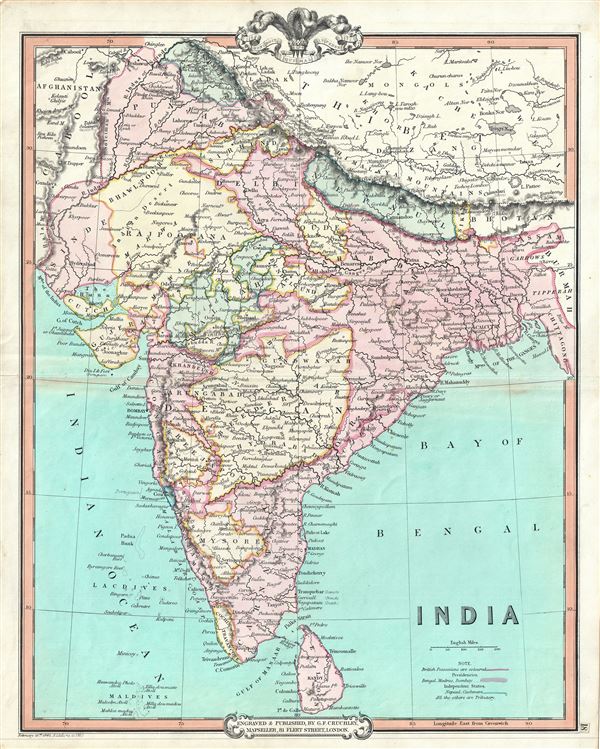
This is an attractive 1850 map of India by George Frederick Cruchley. It covers the Indian subcontinent from Kashmir to the Indian Ocean and includes Ceylon or Sri Lanka as well as parts of Afghanistan and Tibet. The map is color coded according to territories under British Possession, territories under British influence by tribute protection, and independent states. Important towns, cities, rivers, mountains and other topographical features are noted throughout, with relief rendered in hachure.
As this map was being drawn, the Indian subcontinent under the hegemony of the British East India Company. The newly appointed Governor General, Lord Dalhousie brought along several progressive changes including education, railways, canals, telegraph etc. At the same time dissatisfaction with the East India Company was rapidly growing. In 1857, the Sepoys of the British East Indian Company would revolt in India's First War of Independence. This would ultimately lead to the dissolution of the east India Company. Subsequently governance of India would be administered directly by the British Crown. The British Raj ruled India until its independence in 1947.
Cruchley's General Atlas was unique for its period, employing a vivid color scheme extending even to the oceans, distinctive typography, and various uncommon decorative elements including a peacock feather crown and an imprint medallion, both of which break the printed border. Though many of the maps in this atlas are copyrighted in 1841, the atlas was first published in 1843 from the Cruchley office at 81 Fleet Street, London, and proving popular went through numerous reissues well into the 1850s.
Cartographer
George Frederick Cruchley (April 23, 1797 - June 16, 1880) was a London based book and map seller active in the middle part of the 19th century. Cruchley began his cartographic career as an apprentice at the venerable Aaroon Arrowsmith firm. Many of Cruchley's earliest maps bear the words 'From Arrowsmith's' on the imprint. In 1844, Cruchley acquired the massive stock of the important early 19th century firm of John Cary. Cruchley published his own maps as well as reissues of Cary's stock well into the 1870s. He is best known for his detailed plans of London, which in recent years have become increasingly scarce and desirable. Cruchley was based in London on 38 Ludgate Street until 1834 when he moved his offices to 81 Fleet Street. Shortly before his death in 1880 Cruchely auctioned (Hodgson's Auctions, Jan 16, 1877) his entire stock. Many of his map plates were thusly acquired by 'Gall and Inglis' who continued the Cruchley tradition well into the early 20th century. Cruchley's son, also George Frederick (1837 - 1882), continued to work as a book and map seller until his death. More by this mapmaker...
Source
Cruchley, G. F., Selection of Maps from Cruchley's General Atlas, for the use of Schools and Private Tuition, London, 1850.
Condition
Very good. Minor wear and some toning over original centerfold. Blank on verso.