1837 Moor 'Notices of the Indian Archipelago' with Maps: Coleman's Singapore, Penang, etc.
IndianArchipelago-moor-1837$35,000.00


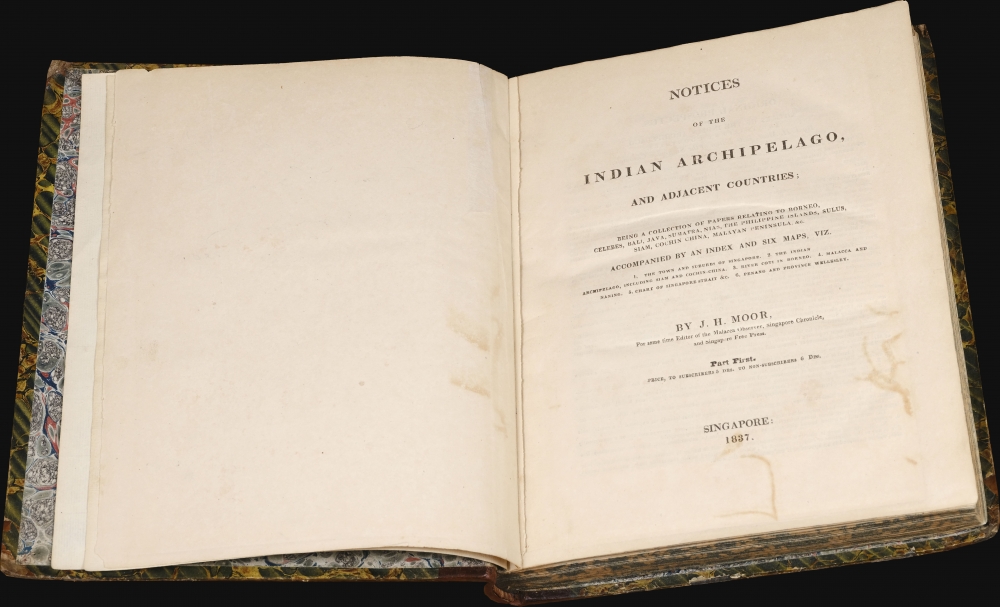


Title
Notices of the Indian Archipelago, and adjacent countries; being a collection of papers relating to Borneo, Celebes, Bali, Java, Sumatra, Nias, the Philippine Islands, Sulu, Siam, Cochin China, Malayan Peninsula, etc.
1837 (dated) 10.5 x 9 in (26.67 x 22.86 cm)
1837 (dated) 10.5 x 9 in (26.67 x 22.86 cm)
Description
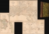
A rare example of John Henry Moor's 1837 Notices of the Indian Archipelago, containing within the most important early map of Singapore, as well as otherwise lost reprints of important articles from the Singapore Chronicle, and additional maps of Penang, Singapore Strait, the East Indian Archipelago, Malacca, and Borneo. Moor's work is considered one of the most significant records of early Singapore and one of the first books published in Singapore.
Unlike the sole earlier map of Singapore, the 1822 Jackson Plan, Coleman's map reflects a comprehensive on-the-ground survey, offering expansive coverage with granular physical detail as regards terrain, land use, roads, rivers, jungle, mangrove swamps, cleared land for sugar and cotton plantations, gambir plantations, pepper plantations, Chinese vegetable farms, sireh gardens, rice fields, brick kilns, and more. It notes lands reserved for Hussein Mohamed Shah (1776 - 1835), Sultan of Johore.
Of note, the map details the Bugis Village on the shores of the Rochor and Kellang Rivers. The Bugis were a trading people originally from Sulawesi, who relocated to Singapore after falling afoul of Dutch traders in Riau (where they had established a community in exile). They were a significant influence on Singapore's early growth as a trading center, but gradually dwindled in the later 19th century.
The further map details many of the most important buildings in early Singapore, several of which were designed by Coleman himself. These include the Singapore Institute (Raffles Institute), the English Church, the Armenian Church, the fortifications at the Battery and Government Hill. Also of note, is Presentment Bridge, the first to cross the Singapore River, built in 1823 and demolished in 1844.
It may be of note that Coleman and Moor knew each other well. Not only did they live and work in the same circles within Singapore Society, but Coleman was the Director of Public Works who built the Singapore Institute, where Moor served as headmaster.
As many have noted, this work was a labor of social responsibility on Moor's part. He was keenly aware that his newspapers were chronicling the earliest days of Singapore's rise as major center of maritime commerce and feared, rightly, that the precious early records would be lost. The book, although easily compiled, took two years to be published due to delays in printing the maps, lack of paper, and lack of sufficient presses.
The maps, in particular, were a daunting challenge - both in terms of costs and resources. With no talented cartographic engravers then in Singapore, a lack of large lithographic presses, and limited access to paper, engraving and printing of the maps had to be outsourced to Jean-Baptiste Tassin in Calcutta. Tassin, perhaps the most active publisher in British India, was the only printer within several thousand miles capable of completing the project to Moor's high standards.
The work was moreover financially disastrous for Moor. Sales of the Notices at 5-6 Spanish Dollars per copy did not meet expectations and failed to cover production costs. Although the prospectus called for a second volume, no such work appeared, perhaps due to Moor's death in 1843, but more likely due to his unwillingness to take a second loss on the project.
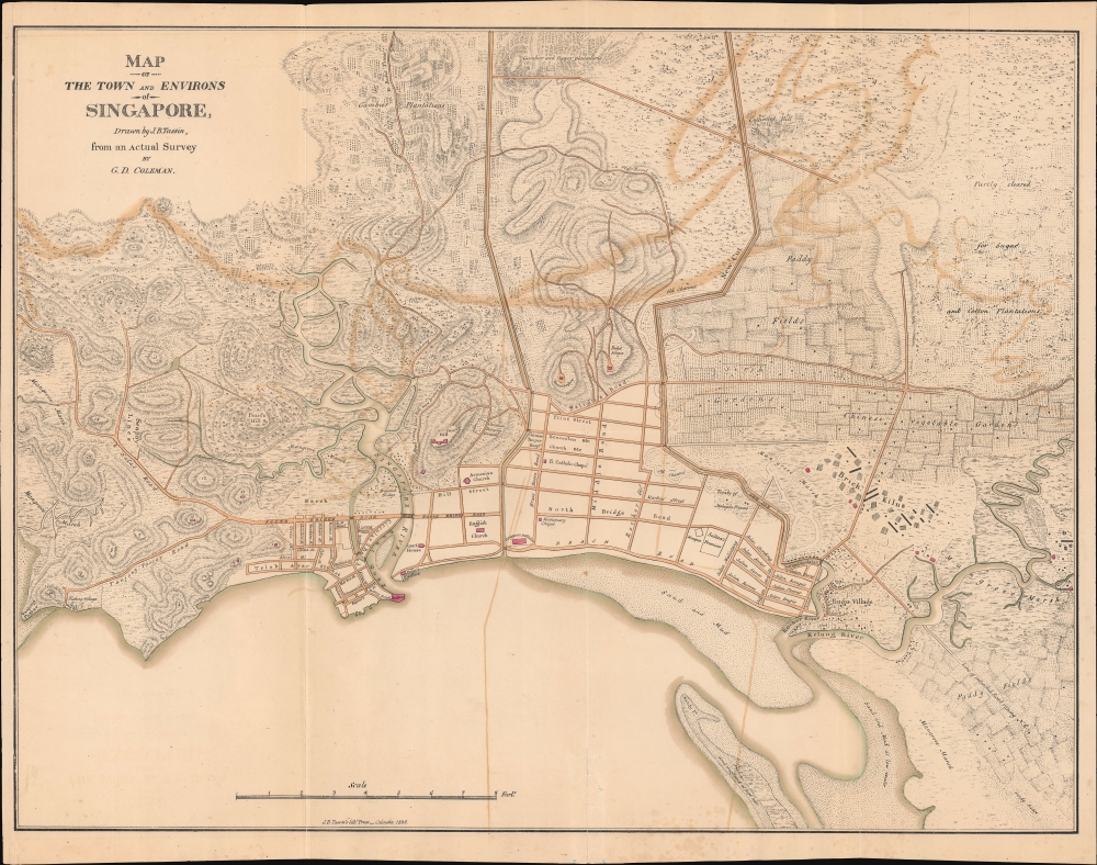
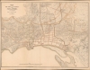
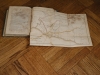
The Map of Singapore
The highlight of the work is J. B. Tassin and George Drumgoole Coleman's spectacular Map of the Town and Environs of Singapore (1 : 11000; 19.5 x 24.75 in). Oriented roughly to the northeast, this is the most significant map of Singapore of the 19th century, being instrumental in the early establishment of streets and sub-communities, as well as subsequent urbanization. In quality and scope, it surpasses all previous and subsequent plans until the 1881 Survey Department map. Although not published until 1836, due to the need to engrave and print in Calcutta, the map reflects Coleman's surveys of 1829.Unlike the sole earlier map of Singapore, the 1822 Jackson Plan, Coleman's map reflects a comprehensive on-the-ground survey, offering expansive coverage with granular physical detail as regards terrain, land use, roads, rivers, jungle, mangrove swamps, cleared land for sugar and cotton plantations, gambir plantations, pepper plantations, Chinese vegetable farms, sireh gardens, rice fields, brick kilns, and more. It notes lands reserved for Hussein Mohamed Shah (1776 - 1835), Sultan of Johore.
Of note, the map details the Bugis Village on the shores of the Rochor and Kellang Rivers. The Bugis were a trading people originally from Sulawesi, who relocated to Singapore after falling afoul of Dutch traders in Riau (where they had established a community in exile). They were a significant influence on Singapore's early growth as a trading center, but gradually dwindled in the later 19th century.
The further map details many of the most important buildings in early Singapore, several of which were designed by Coleman himself. These include the Singapore Institute (Raffles Institute), the English Church, the Armenian Church, the fortifications at the Battery and Government Hill. Also of note, is Presentment Bridge, the first to cross the Singapore River, built in 1823 and demolished in 1844.
It may be of note that Coleman and Moor knew each other well. Not only did they live and work in the same circles within Singapore Society, but Coleman was the Director of Public Works who built the Singapore Institute, where Moor served as headmaster.
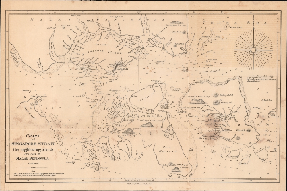
The Singapore Straits Map
The second map of interest is Tassin's chart of Singapore Strait, a general reduction of the Daniel Ross chart of 1830, based on hydrographic work completed in 1827. Ross (1780 - 1849) was serving at the time as the Hydrographer of the East India Company. Singapore is located just north of center, with coverage embracing from Great Carimon to Bintang, and from the Johore River to Pulo Gallang. There are depth soundings throughout, in fathoms, as well as several profile views. Ross's chart was included to underscore's Singapore's ideal situation as a gateway from the Indian Ocean to the China Sea.Penang Island Map
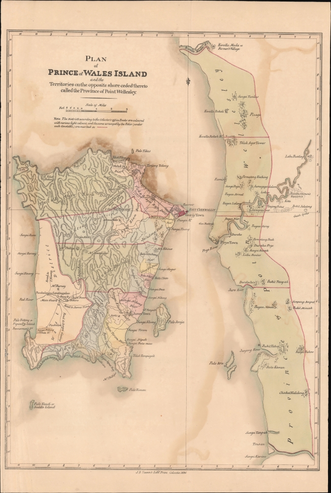
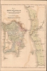
Another map of great interest details Penang Island, then known as Prince of Wales Island, its capital at Georgetown, and the adjacent province of Wellesley. Georgetown was founded on Pulo Penang (Penang Island), off the coast of Kedah, in the Malay peninsula by Francis Light (c. 1740 - 1794) in 1786. Light's mission was to establish trade relations with the Malay Peninsula. He befriended the Sultan of Kedah, who was at the time under threat from both Siam and Burma, as well as fending off an internal revolt. Believing the British to be more reliable allies, the sultan leased Penang Island to the British East India Company as trading center and Royal Navy Base. Light began building fortifications and a port. The colony was immediately prosperous and by 1792 had a population of 10,000, with some 3,500 ships arriving annually. As a stable free port, Georgetown became the center of the Southeast Asia spice trade. In 1826, it was made the capital of the Strains Settlements. Penang's significance as a center of finance lost momentum as trade shifted to the larger and better situated colony of Singapore. In 1832, governance of the Straits Settlements shifted fully to Singapore.Other Maps
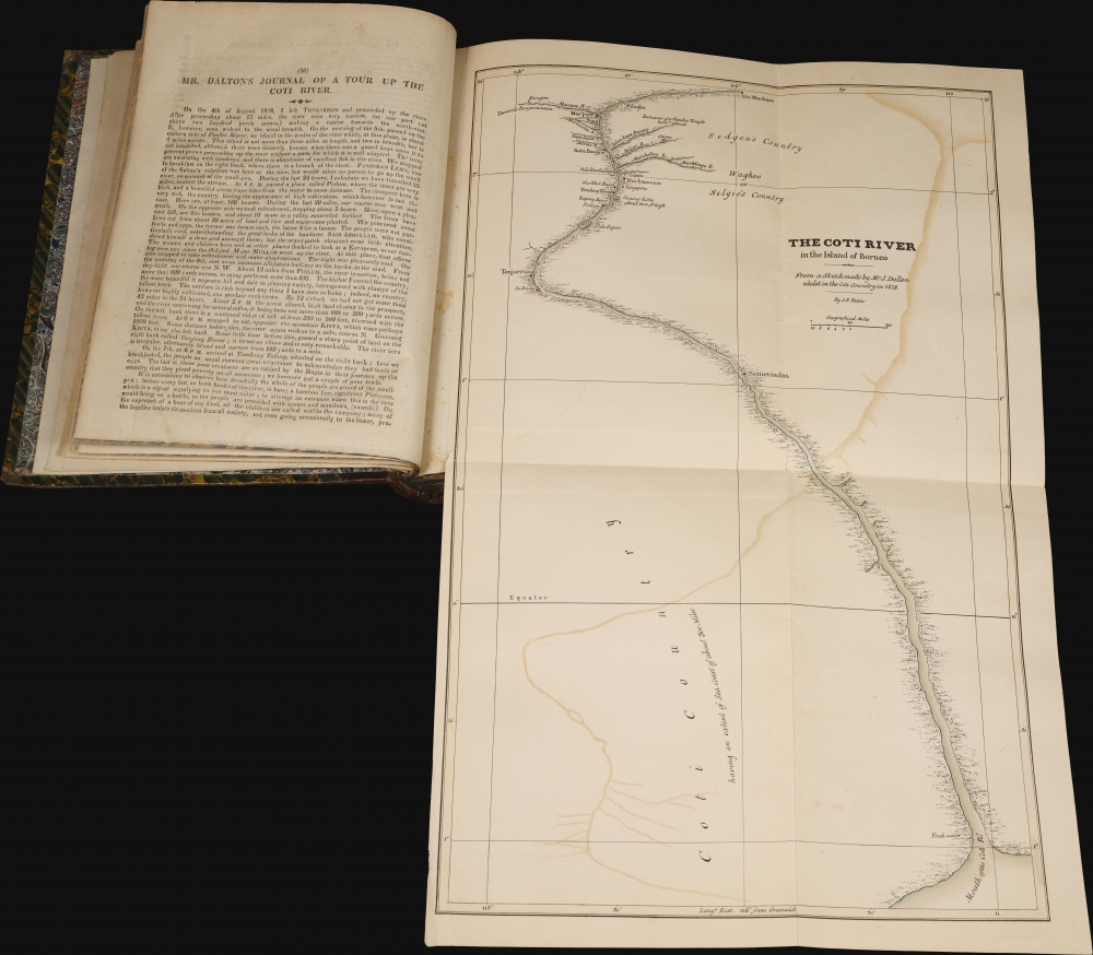
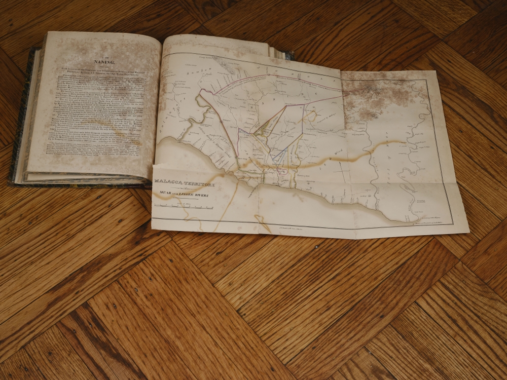
Additional maps contained within include a general map of the East Indies (good condition), a map of the Coti River in Borneo (good condition), and a map of Malacca Territory (complete but in rough condition). All were engraved and printed by Tassin.The Book
The book, Notices of the Indian Archipelago, and Adjacent Countries is nearly as significant as the maps it contains. It is one of the earliest books printed in Singapore. It was published by John Henry Moor, a Singapore newspaperman and editor of the Singapore Chronicle, as well as other papers. The work contains multiple articles extracted from the 1824 - 1834 issues of the Singapore Chronicle, as well as additional notes and commentary on the history of Singapore, the Philippines, Siam, Borneo, Guam, Bali, and other surrounding areas. The newspaper excerpts from the Singapore Chronicle are especially significant, as there are no known surviving copies of the that work for the years 1824 - 1826.As many have noted, this work was a labor of social responsibility on Moor's part. He was keenly aware that his newspapers were chronicling the earliest days of Singapore's rise as major center of maritime commerce and feared, rightly, that the precious early records would be lost. The book, although easily compiled, took two years to be published due to delays in printing the maps, lack of paper, and lack of sufficient presses.
The maps, in particular, were a daunting challenge - both in terms of costs and resources. With no talented cartographic engravers then in Singapore, a lack of large lithographic presses, and limited access to paper, engraving and printing of the maps had to be outsourced to Jean-Baptiste Tassin in Calcutta. Tassin, perhaps the most active publisher in British India, was the only printer within several thousand miles capable of completing the project to Moor's high standards.
The work was moreover financially disastrous for Moor. Sales of the Notices at 5-6 Spanish Dollars per copy did not meet expectations and failed to cover production costs. Although the prospectus called for a second volume, no such work appeared, perhaps due to Moor's death in 1843, but more likely due to his unwillingness to take a second loss on the project.
Dedication
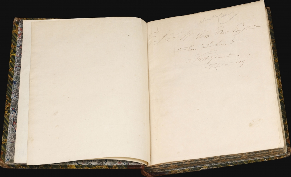
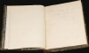
The book features a roughly contemporaneous dedication inscribed 'To J. F. W. Van Nes'. This is likely Johan Frederik Walraven van Nes, a Dutch civil servant in the East Indies form one J. B. Holland, Feb. 10th 1839.Publication History and Census
This work was compiled by John Henry Moor and contained both reissues of Singapore Cornicle articles and original work. It was published in Singapore and printed by the Mission Press. The maps were engraved and printed in Calcutta, India, by J. B. Tassin's Oriental Lithographic Press. The work is extremely rare, especially commercially. We see several examples in the OCLC, including at the University of Pennsylvania, U.S. Berkeley, and Kings College. We are aware of an additional example at the National Library of Singapore, and two in private collections.CartographerS
John Hamilton Moore (1738 - 1807) was a Scottish teacher of navigation, chartseller, and hydrographer active in London during the latter part of the 18th century. He is best known as a publisher of Blueback Nautical Charts and the founder of the firm that would one day become Imary and Son. Moore was born in Edinburgh and was educated in Ireland before joining the Royal Navy. After leaving the navy he set up a navigation academy in Brentford, Middlesex. Around 1772 he published the navigation textbook The New Practical Navigator and Daily Assistant. The work became the most popular such text of its day and ran into some 17 editions, firmly establishing Moore's credentials. Around 1781 Moore established himself at 127 Minories, near Tower Hill, London, where he taught navigation to a select audience as well as traded in navigational instrument and nautical charts. Moore began publishing his own charts. These were among the earliest blueback charts, called such for their distinctive blue paper backing. Moore took on draughtsman William Heather and John Noire, both future publishers of blueback nautical charts in their own right, to drawn and engraves his charts. Personally more was known to be boastful and somewhat controversial. He apparent once described himself as 'having a propensity for genius'. He was also accused of 'debauching a servant'. In the 1790s he started calling himself, 'Hydrographer and Chartmaker to his Royal Highness the Duke of Clarence'. It is unclear whether or not his claim was based on fact, but certainly Moore's many enemies in the chart publishing industry called him out on the matter, publishing a broadside declaring Moore a 'Pretender'. Either way, Moore dropped this claim by 1804. Moore was succeeded by a son, also John Hamilton Moore, and several daughters, one of whom married Robert Blachford, who became a prominent chart publisher in Moore's wake. Despite the seeming prosperity of his business, Moore seems to have died in relative poverty in Chingford, Essex. Nonetheless, his obituary in The Gentleman's Magazine, a sign in and of itself of Moore's social significance, offered him high praise, "he caused the best Charts to be published that had ever been done by any individual in this or any other nation." More by this mapmaker...
George Drumgoole Coleman (1795 - March 27, 1844) was an Irish architect and civil engineer active in the East Indies in the early 19th century. Coleman was born in Drogheda, County Louth, Ireland. He moved to Calcutta in 1815 to work as an architect. In 1820, was invited, through the patronage of John Palmer, to build two churches in Batavia (Jakarta) in the Dutch East Indies. The churches were never built, despite two years of work in Java. Two years later, in 1822, he was in Singapore, under contract from Stamford Raffles (1782 - 1826) to draft the layout of Singapore and plan the town center. He briefly returned to Java in June of 1823, but coming into conflict with local authorities, returned to Singapore in 1825. He designed several important Singapore residences in 1826, before becoming a Revenue Surveyor in June 1827. He built his own Singapore estate in 1828. In 1829, Coleman worked as a Topographical Surveyor, producing a detailed survey of Singapore and the islands where the new harbor was being built. While in this position he surveyed all of Singapore, producing the largest and most detailed yet map of the city yet seen, despite not being engraved and published until 1836. Between in 1833 and 1840, he held the post of Superintendent of Public works and Surveyor of Lands. During this time, he also designed and oversaw the construction of the Armenian Church, St. Andrew's Cathedral, the Court House (former Parliament House), the Convent of the Holy Infant Jesus, and the Singapore Institution (Raffles Institution). After a career of some 15 years in the orient, Coleman left for England in 1841. He married Maria Frances Vernon, of Clontarf Castle, Dublin, in 1842. Unable to re-adjust to Irish life and climate, he returned to Singapore in 1843. There he died in 1844 of a 'fever', likely Malaria. Learn More...
Jean-Baptiste Athanase Tassin (May 3, 1800 - January 25, 1868) was a publisher and lithographic printer active in early 19th century Calcutta, India. Tassin was born in Aix, France, where he trained as a naturalist. He joined a French government expedition to the East Indies as a naturalist. During this voyaged he became a master draughtsman. His ship wrecked in the Malayan archipelago in the late 1820s, leaving Tassin stranded in Singapore. He somehow worked his way to Calcutta, where, receiving a loan of 10,000 Rupees from Henry Thoby Prinsep, he founded publishing house, the Oriental Lithographic Press, specializing in government work. His skill as a draughtsman brought him business as map printer, leading to rich government contracts for such work, his skill often granting him precedence over official government-operated presses. The Oriental Lithographic Press continued to published until c. 1941, but Tassin left India around 1839, with a nest-egg of some 16,000 GBP. He was described with praise in the Calcutta Courier (June 27, 1832),
Mr. Tassin is a gentleman of much sterling worth. He is the most successful of all the lithographer of the East, but he owes much to the aid afforded to him by the experience of others. His zeal, and I may say enthusiasm, for lithography, as well as his industry and perseverance, make up for much of the other requisites.Tassin remained in France throughout the 1840s employed as a cartographer with the French Army. The 1848 February Revolution drove him into exile to San Francisco - just in time for the Gold Rush. He published several maps of San Francisco and California in the mid-1850s and may have been an owner of the Adelphi Theater. The Adelphi burned in 1858, after which Tassin returned to Paris. Ernest de Massey, a fellow Frenchman in San Francisco, recorded meeting Tassin,
Another silhouette ... This one is of Sieur Tassin, Chevalier of the Legion d’Honneur, ex-engineer of geography of the French government, commissioned in the Orient. He seemed to do his work with honesty. He was in haste to leave his business which must have been repugnant to him. Very ingratiating, pleasant and polite, he would have been better suited to a drawing room than a gambling house. He made a fortune and went away. In 1860 I met him on the street of Paris. He was then a 'big' Monsieur Tassin. If I had met him in a drawing-room his face would have shown much more embarrassment, as I do not believe he advertised his ability at the green-covered table where the nuggets were easier to gather than they were in the mines.Tassin died in France of unknown causes. For our research on Tassin we are somewhat indebted to Ashley Baynton-Williams. Learn More...
Condition
Very good. Quarto. quarter straight-grained Morocco overboards (expertly rebacked), spine retains original gilt lettering. Marbled edges. Complete with all maps present. Maps of Singapore, Singapore Strait, and Penang loose in volume with some verso repairs and reinforcements. Other maps bound into volume. Some maps exhibit foxing and transference, especially the Malacca Territory map and adjacent pages. Some foretext leaves exhibit minor repairs near spine. Dimensions reflect book, not maps.
References
Cordier, H., Bibliotheca indosinica. Dictionnaire bibliographique des ouvrages relatifs a la peninsule Indochinoise, p. 734. OCLC 187392678. Edney, Matthew H., Mapping an Empire: The Geographical Construction of British India, 1765-1843, 1997. Gibson-Hill, C. A., 'The Singapore Chronicle (1824-37)' in Journal of the Malaysian Branch of the Royal Asiatic Society, Vol. 42, No. 1, 1969.