1849 Greenleaf Map of Indiana
Indiana-greenleaf-1849$350.00

Title
Indiana.
1849 (undated) 12.75 x 10.75 in (32.385 x 27.305 cm) 1 : 1420000
1849 (undated) 12.75 x 10.75 in (32.385 x 27.305 cm) 1 : 1420000
Description
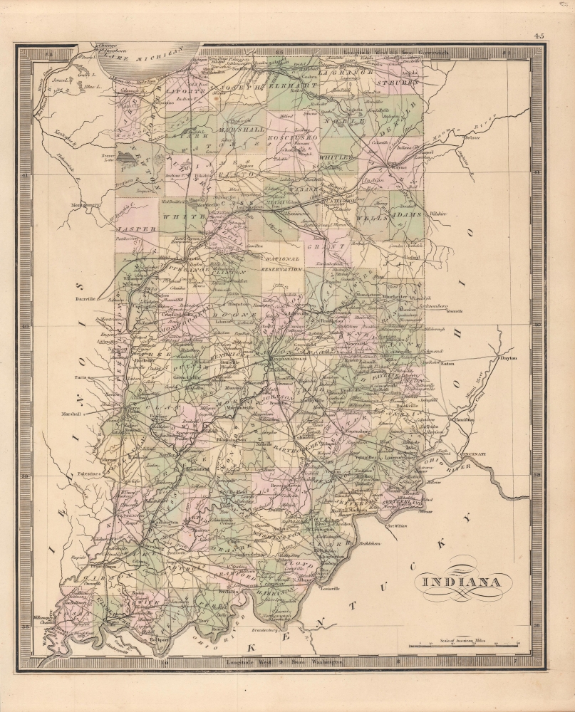
This is Jeremiah Greenleaf's 1849 map of Indiana. It presents the state on the tail end of a process of the removal of native peoples and their replacement with White settlers.
Small numbers of Potawatomi and Miami were able to secure exemptions from the removals based on earlier treaties, while others successfully lobbied the government to return to Indiana after having been relocated to the west. Thus, the 'Pokaggon Settlement' near top, referring to the Pokagon Band of Potawatomi, who had gained an exemption from removal on the Michigan side of the border. Greenleaf's inclusion of the 'National Reservation' below Miami County is anachronistic. It ceased to exist in 1840 with the Treaty of the Wabash and was soon replaced by Howard and Tipton Counties.
A Closer Look
Cities and towns, roads, railroads, and waterways (including canals, denoted by solid black lines) are noted in considerable detail. Counties are shade to aid in distinguishing them from one another. Compared to the earliest edition of the map published in 1835 (see 'Publication History and Census' below), the lands of the Potawatomi and Miami Indians in the northern part of the state have been obliterated and replaced by counties as in the rest of the state. Beginning in the 1830s, the Potawatomi, Miami, and other indigenous peoples were relocated, either by treaty agreement or by force, west of the Mississippi River, with most of the Miami people being forcibly removed by the U.S. military in October 1846.Small numbers of Potawatomi and Miami were able to secure exemptions from the removals based on earlier treaties, while others successfully lobbied the government to return to Indiana after having been relocated to the west. Thus, the 'Pokaggon Settlement' near top, referring to the Pokagon Band of Potawatomi, who had gained an exemption from removal on the Michigan side of the border. Greenleaf's inclusion of the 'National Reservation' below Miami County is anachronistic. It ceased to exist in 1840 with the Treaty of the Wabash and was soon replaced by Howard and Tipton Counties.
Publication History and Census
This map is a much-revised Greenleaf issue of David Hugh Burr's 1835 map of the same. The Burr map plates fell into the hands of Jeremiah Greenleaf, who revised them for publication in his own Universal Atlas. The present example is from the 1849 edition of the atlas, the last and final, which was extensively revised over the 1848 edition. We note an example in the David Rumsey Map collection, which has been populated digitally throughout OCLC, making a comprehensive survey of existing physical examples nearly impossible. Nonetheless, the 1849 edition of the atlas is rare, which Rumsey correctly notes is not in Karpinski. We do note an example, however, in Phillips.CartographerS
Jeremiah Greenleaf (1791 - 1864) is a little known but highly admired American cartographer of the early 19th century. He published from roughly 1830 to 1850. His most important work is A New Universal Atlas; Comprising of all the Principal Empires, Kingdoms, and States Throughout the World and Forming a distinct Atlas of the United States, published in several editions in the 1840s. Many of his maps are reformatted versions of his contemporary David Burr's much admired cartographic works. Greenleaf's maps are extremely rare and admired for their stunningly vivid pastel color washes. More by this mapmaker...
David Hugh Burr (August 18, 1803 - December 25, 1875) of one of the first and most important truly American cartographers and map publishers. Burr was born in Bridgeport Connecticut in August of 1803. In 1822 Burr moved to Kingsboro, New York to study law. A year and a half later he was admitted to the New York Bar association. Burr must have questioned his choice of careers because shortly after being admitted to the Bar, he joined the New York State Militia. Though largely untrained in the art of surveying, Burr was assigned to work under Surveyor General of New York, Simeon De Witt, to survey several New York Roadways. Seeing a window of opportunity, Burr was able to negotiate with the governor of New York at the time, De Witt Clinton, to obtain copies of other New York survey work in order to compile a map and Atlas of the state of New York. Recognizing the need for quality survey work of its territory, the government of New York heartily endorsed and financed Burr's efforts. The resulting 1829 Atlas of the State of New York was the second atlas of an individual U.S. state and one of the most important state atlases ever produced. Burr went on to issue other maps both of New York and of the United States in general. In cooperation with publishing firm of Illman & Pillbrow, he produced an important New Universal Atlas and, with J.H. Colton, several very important maps of New York City. In recognition of this work, Burr was appointed both "Topographer to the Post office" and "Geographer to the House of Representatives of the United States". Later, in 1855, Burr was assigned to the newly created position of Surveyor General to the State of Utah. Burr retired from the position and from cartographic work in general in 1857 when light of some of his financial misdeeds and frauds came to light. He was accused of submitting false expense reports and underpaying employees, among other indiscretions. Learn More...
Source
Greenleaf, J., New Universal Atlas, (Brattleboro, Vermont: Greenleaf) 1849.
Condition
Very good. Even overall toning.
References
Rumsey 15176.049.