This item has been sold, but you can get on the Waitlist to be notified if another example becomes available, or purchase a digital scan.
1909 Stanford Map of Southeast Asia: Thailand, Malaysia, Vietnam, Laos
Indochina-stanford-1909$175.00


Title
Indo-China.
1909 (undated) 21 x 14 in (53.34 x 35.56 cm) 1 : 6969600
1909 (undated) 21 x 14 in (53.34 x 35.56 cm) 1 : 6969600
Description
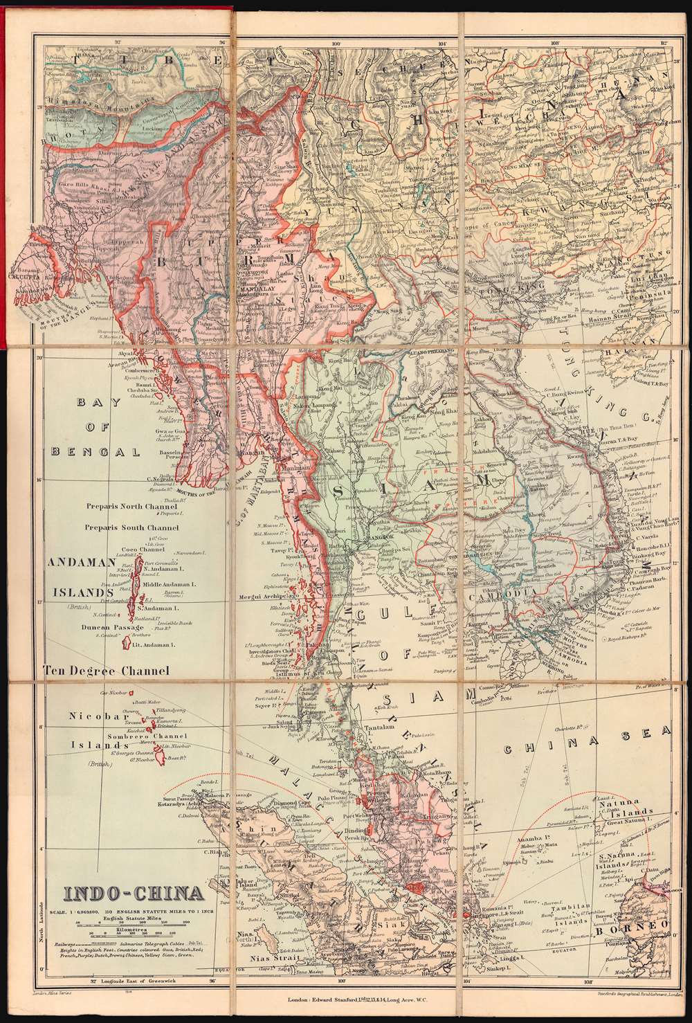
A very attractive c. 1909 Stanford's Geographical Establishment folding map illustrating the colonial situation in Southeast Asia in the early 1900s. Centered on Bangkok, coverage extends from Tibet to Sumatra and Borneo, and from Calcutta to Hainan, embracing all of Siam (Thailand), Malaya, Burma, Laos, Cambodia, and Vietnam.
The Struggle for Southeast Asia
The map offers a British perspective on the struggle with the French over control of Southeast Asia - and the efforts of the Siamese (Thai) to maintain their independence. The map highlights the Straits Settlements - areas fully administered by the British, in red. These included Singapore, Malacca, Penang, and the Dindings. Other areas, like Burma, parts of India, Malaya, and North Borneo, are shaded light red - representing British protectorates. French colonial claims, including modern-day Vietnam, Laos, and Cambodia, are light blue. The Dutch East Indies, including Sumatra and parts of Borneo appear on the southern periphery of the map in light orange. China, to the north and northeast, is yellow. Areas mostly outside of European colonial influence, including Thailand, Bhutan, and the Naga tribal regions of northern Burma and Assam are blue-green. The Naga peoples - known for their fiercely independent warrior culture, resisted European attempts to survey their mountainous territory well into the 20th century - as noted here. Nonetheless, annotations within Thailand suggests that portions were within either the British or French spheres of influence.Publication History and Census
This map is undated, but we are able to somewhat assign a date based on political boundaries. The boundaries of British Malaya extend northward as far as Langkawi Island, which, along with Kedah, was seized form Siam in 1909. It likewise recognizes French expansion into northeastern (1904) and southwestern (1907) Siam. The map was part of the London Atlas series, but is here presented separately in sectionalized and mounted format. Uncommon.Cartographer
Edward Stanford (May 27, 1827 - November 3, 1904) was one of the most prolific map publishing firms of the late 19th century. The company began as a partnership in 1848 between the 21 year old Edward Stanford and the established map dealer Trelawney Saunders. By 1853 the partnership had dissolved and Edward Stanford took full control of the business. A subsequent series of expansions and exciting new map issues finally led to the production of Stanford's masterwork, "Stanford's Library Map of London". This map is still available and remains somewhat accurate. At the time of publishing it was hailed by the Royal Geographical Society as "the most perfect map of London that has ever been issued". In 1882 Edward Stanford Sr. passed the firm on to his son, Edward Stanford Jr. who continued in his father's proud tradition. Today the Stanford firm still publishes maps and remains one of the most important and prolific cartographic publishers in the world. More by this mapmaker...
Condition
Very good. Attached to original red linen binder. Sectionalized and mounted on linen for easy folding and unfolding.
References
OCLC 920926081.