1782 Brion de la Tour Map of Menorca and the 1781 Franco-Spanish Invasion
InvasionMinorque-briondelatour-1782$2,100.00


Title
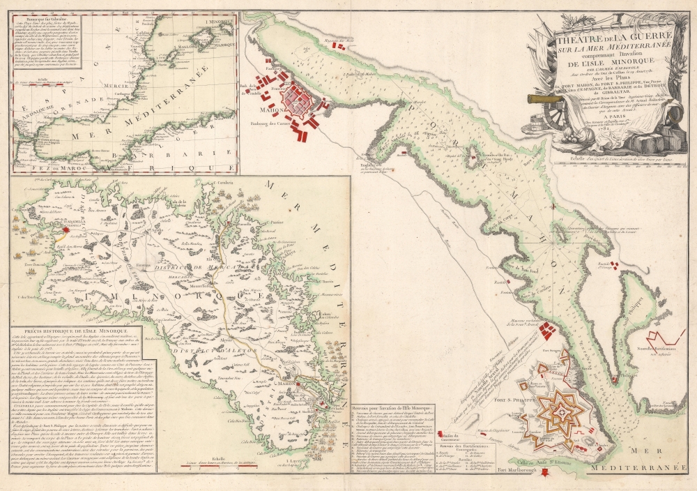
Théâtre de la Guerre sur la Mer Méditerranée comprennant l'Invasion de l'Isle Minorque par l'Armée Espagnole aux Ordres du Duc de Crillon le 19 Aoust 1781 avec les Plans du Port Mahon, du Fort S. Philippe, une Partie des Côtes d'Espagne, de Barbarie et du Détroit de Gibraltar.
1782 (dated) 20.75 x 30 in (52.705 x 76.2 cm) 1 : 8400
1782 (dated) 20.75 x 30 in (52.705 x 76.2 cm) 1 : 8400
Description
This is a 1781 Louis Brion de la Tour map of Menorca illustrating the 1781 Franco-Spanish invasion of Menorca. The map marks the end of roughly 20 years of British control of Menorca and the return of the island to Spanish sovereignty.
A Closer Look
The central map highlights Fort St. Philippe and the town of Mahon. The Fort appears in detail, with the royal battery, fortifications (including lunettes), the arsenal, and the hospital labeled. Ten other locations (four counterguards and six ravelins) are alphabetically identified and correspond with a key along the bottom border. An inset map of Menorca illustrating the island in detail occupies the lower left. Sixteen events and locations related to the invasions are illustrated with a corresponding key to the right of the inset. Coastal islands and inlets are labeled, along with cities, towns, and villages. A short history of Menorca appears in the lower left. A second inset in the upper left situates Menorca in relation to British Gibraltar, where a second siege was underway. A short paragraph entitled 'Remark on Gibraltar' occupies the upper right and provides context.The 1781 Invasion of Menorca
The 1781 Franco-Spanish invasion of Menorca was part of the wider war sparked by French intervention in the American Revolutionary War (1775 - 1783). Britain captured the island during the Seven Years' War (1756 - 1763). In 1781, coordinated French and Spanish fleets attacked British Menorca, successfully landing troops at multiple locations. While the invasion was meant to be a surprise, the large fleets did not go unnoticed, and the British strategically withdrew into Fort St. Philippe. The French commander attempted unsuccessfully to negotiate the British garrison's surrender and, failing, began a five-month siege. Eventually, scurvy defeated the British, who were allowed to surrender with honor and were sent back to England on British ships.Publication History and Census
This map was drawn by Louis Brion de la Tour and published by Esnauts and Rapilly in 1782. We note three cataloged examples worldwide, which are part of the collections at the Archives nationales de France, the Universiteitsbibliotheek Utrecht, and the Universitätsbibliothek Bern. We note only one other instance when this piece has appeared on the private market.CartographerS
Louis Brion de la Tour (1743 - 1803) was the Cartographer Royal to the King of France, his official title being Ingenieur-Geographe du Roi. Despite a prolific cartographic career and several important atlases to his name, little is actually known of his life and career. He may have been born in Bordeaux. His son of the same name was born in 1763 and published until his death in 1832. It is nearly impossible to distinguish the work of the father from the work of the son, as both used the same imprint and were active in roughly the same period. Much of their work was published in partnership Louis Charles Desnos (fl. 1750 - 1790). Their most notable work is generally regarded to be his 1766 Atlas General. More by this mapmaker...
Esnauts and Rapilly (fl. c. 1775 - 1811) were Paris based print sellers and publishers active in the latter part of the 18th century. The firm was founded by Jacques Esnauts and Michel Rapilly. Esnauts and Rapilly are best known not for their cartographic works, but rather for their fashion prints. The important publication La Galerie des Modes highlighted the fashions of the French aristocracy just prior to the French Revolution and is considered to be the first published "fashion magazine". At this time, Paris was the center of the fashion world and Esnauts and Rapilly's plates were widely distributed to eager fashionistas the world over. The firm also published a number of important and influential maps including several depicting pivotal moments in the American Revolutionary War. Not wanting to miss out on potential customers, Esnauts and Rapilly gave exact directions to their bookshop on many of their publications: "at the Baker's shop, opposite the Cutler." Learn More...
Condition
Very good. Light wear along original centerfold.
References
Archives nationales de France NN/386/35. OCLC 902704305.