1866 Colton Sectional Pocket Map of Iowa
Iowa-colton-1866$500.00

Title
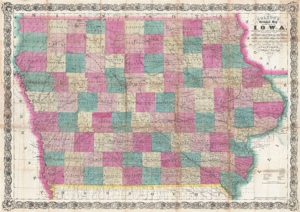
Colton's Sectional Map of the State of Iowa. Compiled from the U.S. Surveys and other Authentic Sources. Exhibiting the Sections Fractional Sections, Counties, Cities, Towns, Villages, Post Offices, Railroads and other Internal Improvements.
1866 (dated) 27.5 x 39 in (69.85 x 99.06 cm) 1 : 570200
1866 (dated) 27.5 x 39 in (69.85 x 99.06 cm) 1 : 570200
Description
This is an 1866 G. W. and C. B. Colton separate issue large format pocket map of Iowa - issued at during a period of explosive economic and population growth for Iowa. The completion of the Union Pacific Railroad, which departed from Omaha City, Nebraska, transformed Iowa into a transportation and economic hub, at the center of a trans-continental railroad network. The map depicts all of Iowa from Dakota and Nebraska to Wisconsin and Illinois and from Minnesota to Missouri. Highly detailed, myriad cities, towns, and villages are labeled throughout, including county seats and Des Moines, the state capital. Each county is labeled and shaded for easy differentiation. The map is further divided sectionally into land districts as surveyed by the United States Land Office. Numerous railroads crisscross the state, such as the Mississippi and Missouri Railroad and the Keokuk, Des Moines, and Minnesota Railroad. The Union Pacific Railroad is illustrated leaving Omaha City, Nebraska, which lies across the Missouri River from Iowa. Several roads are also depicted, such as the military road from Sioux City to St. Paul. Rivers and creeks snake their way across the state, some of which empty into the various lakes which dot the landscape
Publication History and Census
This map was produced by J. H. Colton and published by his sons, G. W. and C. B. Colton in 1866. We are aware of one earlier edition, dated to 1865, suggesting this is the second edition.Cartographer
Joseph Hutchins Colton (July 5, 1800 - July 29, 1893), often publishing as J. H. Colton, was an important American map and atlas publisher active from 1833 to 1897. Colton's firm arose from humble beginnings when he moved to New York in 1831 and befriended the established engraver, Samuel Stiles. He worked under Stiles as the 'Co.' in Stiles and Co. from 1833 to 1836. Colton quickly recognized an emerging market in railroad maps and immigrant guides. Not a cartographer or engraver himself, Colton's initial business practice mostly involved purchasing the copyrights of other cartographers, most notably David H. Burr, and reissuing them with updated engraving and border work. His first maps, produced in 1833, were based on earlier Burr maps and depicted New York State and New York City. Between 1833 and 1855, Colton proceeded to publish a large corpus of guidebooks and railroad maps, which proved popular. In the early 1850s, Colton brought his two sons, George Woolworth Colton (1827 - 1901) and Charles B. Colton (1832 - 1916), into the map business. G. W. Colton, trained as a cartographer and engraver, was particularly inspired by the idea of creating a large and detailed world atlas to compete with established European firms for the U.S. market. In 1855, G.W. Colton issued volume one of the impressive two-volume Colton's Atlas of the World. Volume two followed a year later. Possibly because of the expense of purchasing a two-volume atlas set, the sales of the Atlas of the World did not meet Colton's expectations, and so, in 1856, the firm also issued the atlas as a single volume. The maps contained in this superb work were all original engravings, and most bear an 1855 copyright. All of the maps were surrounded by an attractive spiral motif border that would become a hallmark of Colton's atlas maps well into the 1880s. In 1857, the slightly smaller Colton's General Atlas replaced the Atlas of the World. Most early editions of the General Atlas published from 1857 to 1859 do not have the trademark Colton spiral border, which was removed to allow the maps to fit into a smaller format volume. Their customers must have missed the border because it was reinstated in 1860 and remained in all subsequent publications of the atlas. There were also darker times ahead; in 1858, Colton was commissioned at a sum of 25,000 USD by the government of Bolivia to produce and deliver 10,000 copies of a large format map of that country. Although Colton completed the contract in good faith, delivering the maps at his own expense, he was never paid by Bolivia, which was at the time in the midst of a series of national revolutions. Colton would spend the remainder of his days fighting with the Bolivian and Peruvian governments over this payment, and in the end, after a congressional intervention, he received as much as 100,000 USD in compensation. Nonetheless, at the time, it was a disastrous blow. J. H. Colton and Company is listed as one of New York's failed companies in the postal record of 1859. This led Colton into the arms of Alvin Jewett Johnson and Ross C. Browning. The 1859 edition of Colton's General Atlas lists Johnson and Browning as the 'Successor's to J. H. Colton' suggesting an outright buyout, but given that both companies continued to publish separately, the reality is likely more complex. Whatever the case may have been, this arrangement gave Johnson and Browning access to many of Colton's map plates and gave birth to Johnson's New Illustrated (Steel Plate) Family Atlas. The Johnson's Atlas was published parallel to Colton's atlases well into the 1880s. The Colton firm itself subsequently published several other atlases including an Atlas of America, the Illustrated Cabinet Atlas, the Octavo Atlas of the Union, and Colton's Quarto Atlas of the World. They also published a large corpus of wall maps, pocket maps, and guides. The last known publications of the Colton firm date to 1897 and include a map and a view, both issued in association with the Merchant's Association of New York. Alice M. Colton married August R. Ohman (May 3, 1859 - April 22, 1934) on January 5, 1897. In 1898, Ohman joined the Colton firm, which continued to publish as Colton, Ohman & Co. until 1901. More by this mapmaker...
Condition
Average. Backed on archival tissue for stability. Wear and toning along original fold lines. Infill rectifying loss on right side of map passing through Delaware, Linn, and Johnson Counties. Additional points of infill at fold intersections. Light soiling. Blank on verso.
References
OCLC 36494840.