1829 Llyod Map of the Isthmus of Panama, Proposed Railways
IsthmusPanama-lloyd-1829$500.00

Title
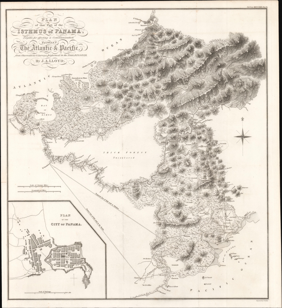
Plan of that Part of the Isthmus of Panama Eligible for effecting a Communication Between The Atlantic and Pacific from Observations and Surveys performed in the Years 1828 and 1829.
1829 (dated) 17.5 x 16 in (44.45 x 40.64 cm) 1 : 175000
1829 (dated) 17.5 x 16 in (44.45 x 40.64 cm) 1 : 175000
Description
This is John Augustus Lloyd's 1828 - 1829 survey of potential railway routes across the Isthmus of Panama. Produced at the request of El Libertador Simón Bolívar (1783 - 1830), this is the first map to represent a serious attempt at an interoceanic connection in Panama.
Nevertheless, the promoters of such a railway correctly judged its future utility, especially impressive given that commercially viable railways were still a recent development. Though Lloyd's proposed routes never came to fruition, a railway across the isthmus was eventually built in the 1850s (discussed below), albeit along a route cutting straight through the thick unexplored forest at center to link Manzanilla with Panama City. Nearly seventy years later, and some ninety years after Lloyd's surveys, the Panama Canal was opened, largely following the Chagres River where possible.
A Closer Look
Oriented towards the north, coverage includes the narrowest part of the isthmus, seen as the most practicable for any railway joining the oceans. At the time, the only means of traveling across the isthmus were dirt roads built under the Spanish (displayed here) which were dangerous and prone to washing away during floods. Lloyd, an Englishman trained as a military surveyor, was hired by the Venezuelan government in 1827 as an engineering officer. Simón Bolívar immediately set him to surveying potential routes for a railway across the Isthmus of Panama, resulting in the work seen here, though as can be seen Lloyd's survey of the areas through which the railway would pass is rather cursory. Lloyd's map further demonstrates why such a project would be extremely difficult, even if the terrain was well-known; high mountains, thick forests, and swamps lie in the way of any effort to build a railway, not to mention tropical diseases, stifling heat, seasonal floods, and other impediments.Nevertheless, the promoters of such a railway correctly judged its future utility, especially impressive given that commercially viable railways were still a recent development. Though Lloyd's proposed routes never came to fruition, a railway across the isthmus was eventually built in the 1850s (discussed below), albeit along a route cutting straight through the thick unexplored forest at center to link Manzanilla with Panama City. Nearly seventy years later, and some ninety years after Lloyd's surveys, the Panama Canal was opened, largely following the Chagres River where possible.
The Panama Railroad
Less well-known than the more famous canal, the Panama Railroad was the first major trans-isthmus link and an engineering marvel in its own right. The idea for a trans-continental channel between the Pacific and Atlantic can be traced to the Spanish colonial period, when dirt roads and trails crossed the isthmus. Most such roads fell into disrepair during the Napoleonic Wars and Latin American wars of Independence. Alexander von Humboldt, Simon Bolívar, and Andrew Jackson all proposed building a more durable route across the isthmus, and plans began in earnest in the 1830s for a railroad or canal. However, logistical and financial challenges ruined these early efforts before they could get off the ground. A plan in the late 1840s gained more traction, thanks in part to fortuitous timing, coinciding with the California Gold Rush (1848 - 1850). American businessman William Henry Aspinwall and his partners founded the Pacific Mail Steamship Company in 1848 and immediately set about drumming up interest and capital for a railway in Panama under the auspices of the Panama Railroad Company. Battling swampy ground, dense forests, broiling heat, and tropical diseases, the project was completed by 1855 at the cost of thousands of workers' lives, but it quickly became one of the most profitable railways in the world.Publication History and Census
This map was prepared to illustrate John Augustus Lloyd's article 'Account of Levellings Carried Across the Isthmus of Panama,' presented at the Royal Society in 1830. It was engraved by 'J. Gardner', most likely James Gardner (fl. c. 1808 - 1840), a surveyor who was a founding member of the Royal Geographical Society. The map is only independently cataloged in the OCLC in its 1839 reprinted edition, published as U.S. House Documents, 25th Congress, 3rd session, No. 322, while the entire 1830 article published by the Royal Society is more widespread.Source
Lloyd, J. A., 'Account of levellings carried across the Isthmus of Panama, : to ascertain the relative height of the Pacific Ocean of Panamá and of the Atlantic at the mouth of the river Chagres; accompanied by geographical and topographical notices of the isthmus,' in Philosophical transactions of the Royal Society, (London: Royal Geographical Society) 1830.
Condition
Very good. Original fold lines exhibit slight wear. Lower left margin extended.
References
OCLC 1113869260 (1839 reprint in U.S. House Docs.)