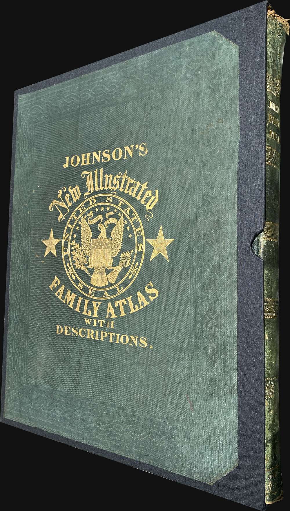
1862 Civil War 'Richmond Edition' of Johnson's New Illustrated Family Atlas
JohnsonAtlasRichmond-johnson-1862$3,500.00

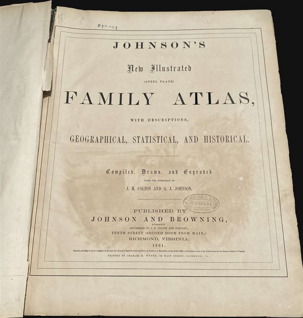
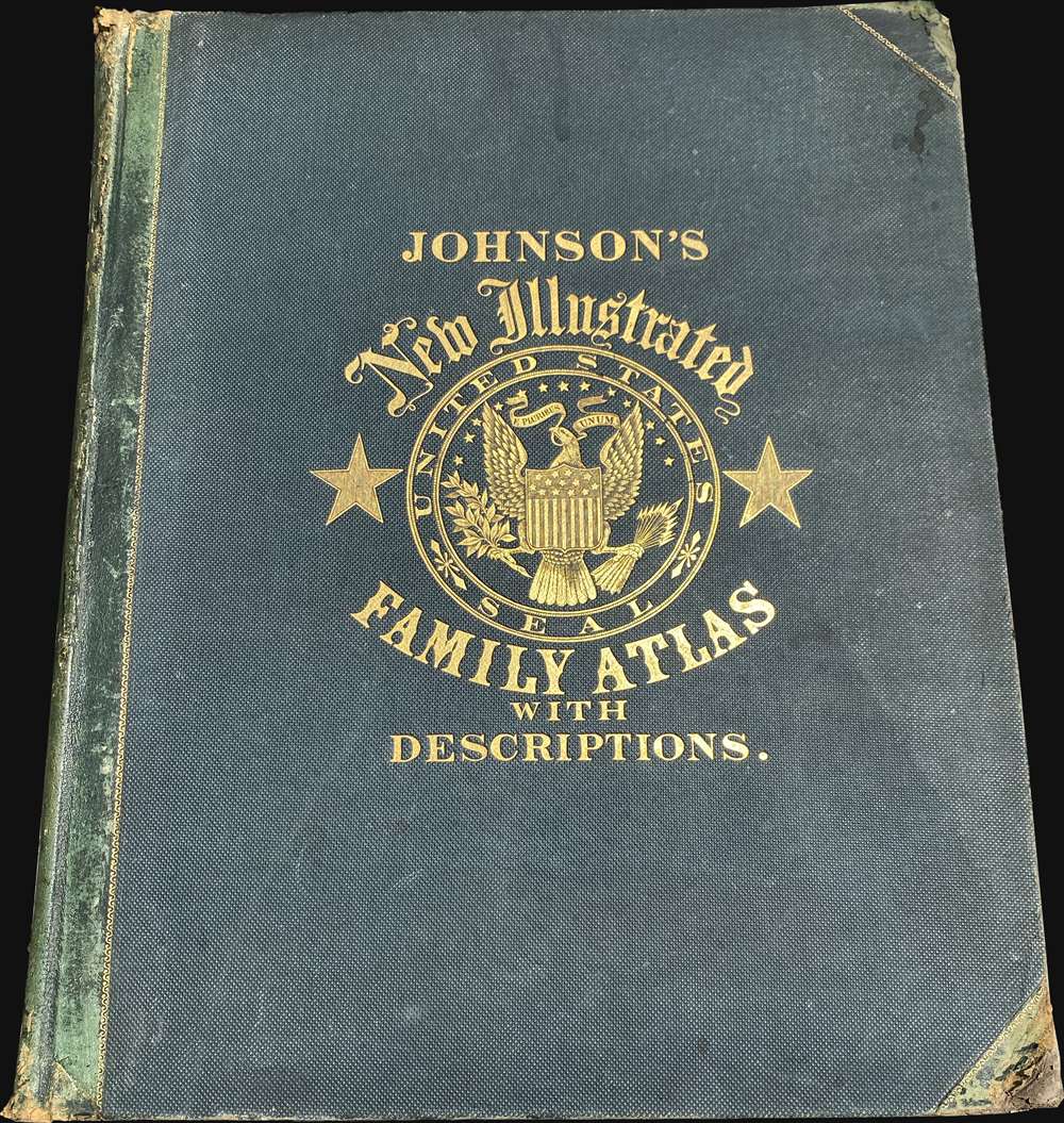

Title
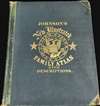
Johnson's New Illustrated (Steel Plate) Family Atlas.
1862 (dated) 19 x 15 in (48.26 x 38.1 cm)
1862 (dated) 19 x 15 in (48.26 x 38.1 cm)
Description
A rare Richmond-issue Civil War edition of Johnson's New Illustrated (Steel Plate) Family Atlas published in Richmond in 1861. It is one of the only atlases published in the Confederacy during the American Civil War (1861 - 1865).
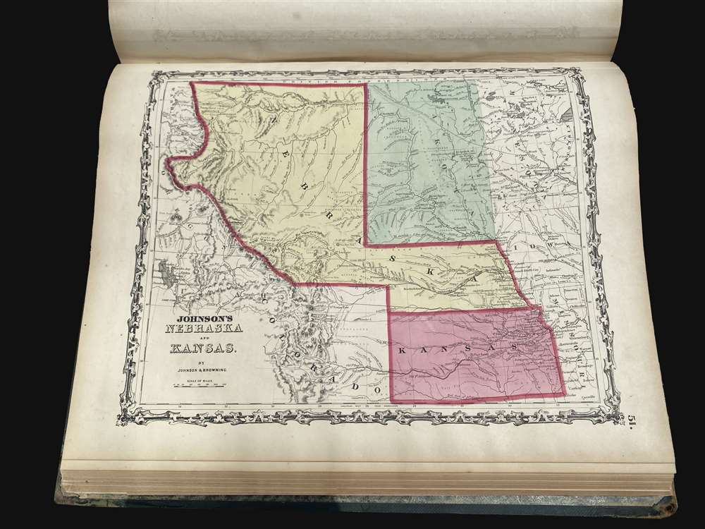
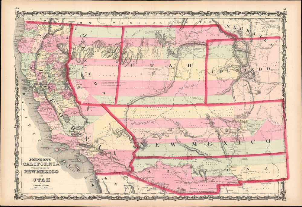
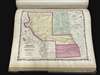
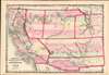
In content, it is largely similar to the 1861 edition issued in New York, but has two exceptionally rare maps in unrecorded states, both significant. The first is the map of Kansas and Nebraska, and the other is the Southwest map covering modern-day California, Arizona, New Mexico, Nevada, Colorado, Utah, and Wyoming. This second map is likely the first printed map to illustrate the territory of Colorado.
Retrospectively, Confederate Arizona appears in Johnson atlases as early as April 1860, when a constitution for the 'Territory of Arizona' was drafted in Tucson. When Congress rejected the Arizona Constitution, late in 1860, it was removed from the New York edition of the Atlas, but retained in the Richmond edition - potentially reflecting the printer Charles H. Wynne's Confederate political leanings. A more comprehensive history of Confederate Arizona is below.
The map also differs in that Utah includes a panhandle that extends eastward north of Colorado to the Rocky Mountains and the borders of Nebraska Territory. As with the previously highlighted map of Kansas and Nebraska Territory, this reflects ambiguity over the borders and creation of Dakota Territory but recognition of the February 28, 1861 ratification of Colorado Territory. In the March 2, 1861 Congressional act that created the Dakota Territory, this panhandle was ceded to Nebraska. This again underscores that these maps must have been sent to the presses between February 28 and March 2, 1861.
Also of interest, this is the first Johnson map to include Colorado and potentially the first published map to include Colorado. For the reasons above, it is likely that this map was issued just days after the territory was ratified. The map includes a Nevada-California border along the Sierra Nevada mountains that, in later land disputes, would be moved east to accommodate gold and silver discoveries. Similarly, the Utah-Nevada border here would later be removed to further to equalize the two states. The capital of Utah is noted as 'Fillmore City'.
At the beginning of the Civil War, support for the Confederacy ran high in the southern parts of the New Mexico Territory. Local concerns drove this sentiment, including a belief that the war would lead to an insufficient number of Federal troops to protect the citizens from the Apache, while others simply felt neglected by the government in Washington. Also, the Butterfield Overland Mail Route (an overland mail and stagecoach route from Memphis and St. Louis to San Francisco) was closed in 1861, depriving Arizona of its primary connection to California and the East Coast.
All of these factors led to the people of the southern New Mexico Territory to formally call for secession, and a convention adopted a secession ordinance on March 16, 1861, with a subsequent ordinance ratified on March 28, establishing the provisional territorial government of the Confederate 'Territory of Arizona'. The Confederate Arizona Territory was officially proclaimed on August 1, 1861 following Lieutenant-Colonel J. R. Baylor's victory over Union forces in the First Battle of Mesilla, and the territory was officially recognized by the government of the Confederacy on February 14, 1862. However, by July 1862, Union forces from California, known as the 'California Column,' were marching on the territorial capital of Mesilla. Sent to protect California from a possible Confederate incursion, the 'California Column' drove Confederate forces out of the city, allowing them to retreat to Franklin, Texas. The territorial government fled as well and spent the rest of the war in 'exile'. First, they retreated to Franklin, then, after Confederate forces abandoned Franklin and all of West Texas, to San Antonio, where the 'government-in-exile' would spend the rest of the war. Confederate units from Arizona would fight for the rest of the war, and delegates from Arizona attended both the First and Second Confederate Congresses.
A Closer Look
While Johnson atlases are not, in general, considered rare, the 1861 Richmond issue is a genuine rarity. By that time, the American Civil War (April 12, 1861 - April 9, 1865) had begun in earnest. The Atlas was printed in Richmond by Charles H. Wynne. It was Wynne's last publication before joining the Confederate cause in the Virginia Artillery and transitioning his presses to war bonds, Confederate currency, and other war materials.In content, it is largely similar to the 1861 edition issued in New York, but has two exceptionally rare maps in unrecorded states, both significant. The first is the map of Kansas and Nebraska, and the other is the Southwest map covering modern-day California, Arizona, New Mexico, Nevada, Colorado, Utah, and Wyoming. This second map is likely the first printed map to illustrate the territory of Colorado.
Comparing the Richmond vs. New York Editions
The 1861 editions of Johnson's Atlas printed in New York and Richmond are similar but not identical. The Richmond 1861 edition, as here, was printed in Richmond by Charles H. Wynne. The New York edition was printed in New York later in the year by D. McLellan and Bros. Evidence from the Atlas suggests that there were at least two sets of plates, which while mostly similar, were not identical, especially the following two maps. The differences may reflect the tense situation in Richmond just before the war and the need to rush the plates to press. Work on the Atlas in Richmond was left to Browning, who completed and printed it early in 1861, just as the war broke out. Being a Union man, Browning was eager to leave the Confederacy behind and managed with considerable difficulty to sneak across lines in late April or May of 1861. Thus, the two maps described below exhibit ambiguity not present in the 1861 New York edition. The differences are highlighted in the individual map descriptions below, but as a whole, they can be attributed to plates that had not been updated and revised regarding the March 2 creation of Dakota territory before being sent to the presses and potential Confederate pandering on the part of the printer.Johnson's Nebraska and Kansas
This map presents Kansas and Nebraska in an unusual configuration we have not previously seen. The map recognizes the secession of territory in southwestern Nebraska to Colorado on February 28, 1861, but not the acquisition of new western lands from Washington Territory or the full creation of Dakota Territory, which occurred on March 2, 1861. When Minnesota became a state in 1858, its western boundary was drawn at roughly the 96.4th Meridian, leaving the former Minnesota territory lands to the west unincorporated. Here, Dakota, shaded green, remains ambiguous, with no firm shaded boundaries to the east, indicating that the cartographers knew that Dakota territory was in the works but had yet to be defined. The western Dakota boundary here aligns with the 103rd Meridian. There is no natural boundary here, and we can find no reference to this boundary in Congressional records of the period. However, it does come up later in negotiations with the Sioux and Teton nations. Thus, the ambiguous mapping here suggests this map was drafted sometime after February 28 but before March 2. Alternatively, this may reflect the interests of the Confederacy. By the time this map was issued, the Civil War had not yet broken out, but the Confederacy had formed, and multiple states had seceded. Although Confederate interests were not well established in either Nebraska Territory or Dakota, they may have had an agenda reflected here.Johnson's California, Territories of New Mexico and Utah
A most unusual variant state of the important Johnson map of the southwest, covering all of modern-day California, Nevada, Utah, Colorado, Arizona, and New Mexico. Although the map offers much of interest, it is distinctive for its illustration of Confederate Arizona. While both the New York and Richmond editions of 1861 feature a printed east-west running border for Confederate Arizona, only the Richmond edition highlights it as a separate territory. When this map was issued early in 1861, the Territory of Arizona did not exist. Nonetheless, being below the demarcation line set for in the Missouri Compromise and having heavy Confederate sympathies, the Confederacy certainly wanted Arizona Territory to exist. We can assume that its appearance here represents pandering to Southern interests.Retrospectively, Confederate Arizona appears in Johnson atlases as early as April 1860, when a constitution for the 'Territory of Arizona' was drafted in Tucson. When Congress rejected the Arizona Constitution, late in 1860, it was removed from the New York edition of the Atlas, but retained in the Richmond edition - potentially reflecting the printer Charles H. Wynne's Confederate political leanings. A more comprehensive history of Confederate Arizona is below.
The map also differs in that Utah includes a panhandle that extends eastward north of Colorado to the Rocky Mountains and the borders of Nebraska Territory. As with the previously highlighted map of Kansas and Nebraska Territory, this reflects ambiguity over the borders and creation of Dakota Territory but recognition of the February 28, 1861 ratification of Colorado Territory. In the March 2, 1861 Congressional act that created the Dakota Territory, this panhandle was ceded to Nebraska. This again underscores that these maps must have been sent to the presses between February 28 and March 2, 1861.
Also of interest, this is the first Johnson map to include Colorado and potentially the first published map to include Colorado. For the reasons above, it is likely that this map was issued just days after the territory was ratified. The map includes a Nevada-California border along the Sierra Nevada mountains that, in later land disputes, would be moved east to accommodate gold and silver discoveries. Similarly, the Utah-Nevada border here would later be removed to further to equalize the two states. The capital of Utah is noted as 'Fillmore City'.
Confederate Arizona
Confederate Arizona was a territory claimed by the Confederate States of America from 1861 until 1865. The idea for an Arizona Territory appeared as early as 1856 when the government of the Territory of New Mexico began to express concerns about being able to effectively govern its southern parts, as it was separated from Santa Fe by the Jornada del Muerto, a particularly unforgiving stretch of desert. The New Mexico territorial legislature acted on these concerns in February 1858, approving a resolution in favor of creating an Arizona Territory, with a north-south border to be defined along the 32nd Meridian (from Washington). Impatiently waiting for Congress to approve the creation of the new territory, 31 delegates met at a convention in Tucson in April 1860 and drafted a constitution for the 'Territory of Arizona', which was to be organized out of the New Mexico Territory below 34th parallel. The convention even elected a territorial governor and a delegate to Congress. Congress, however, was reluctant to act. Anti-slavery Representatives knew that the proposed territory was located below the line of demarcation set forth by the Missouri Compromise for the creation of new slave and free states, and they were not inclined to create yet another slave state. Thus, Congress never ratified the proceedings of the Tucson convention, and the Provisional Territory was never considered a legal entity.At the beginning of the Civil War, support for the Confederacy ran high in the southern parts of the New Mexico Territory. Local concerns drove this sentiment, including a belief that the war would lead to an insufficient number of Federal troops to protect the citizens from the Apache, while others simply felt neglected by the government in Washington. Also, the Butterfield Overland Mail Route (an overland mail and stagecoach route from Memphis and St. Louis to San Francisco) was closed in 1861, depriving Arizona of its primary connection to California and the East Coast.
All of these factors led to the people of the southern New Mexico Territory to formally call for secession, and a convention adopted a secession ordinance on March 16, 1861, with a subsequent ordinance ratified on March 28, establishing the provisional territorial government of the Confederate 'Territory of Arizona'. The Confederate Arizona Territory was officially proclaimed on August 1, 1861 following Lieutenant-Colonel J. R. Baylor's victory over Union forces in the First Battle of Mesilla, and the territory was officially recognized by the government of the Confederacy on February 14, 1862. However, by July 1862, Union forces from California, known as the 'California Column,' were marching on the territorial capital of Mesilla. Sent to protect California from a possible Confederate incursion, the 'California Column' drove Confederate forces out of the city, allowing them to retreat to Franklin, Texas. The territorial government fled as well and spent the rest of the war in 'exile'. First, they retreated to Franklin, then, after Confederate forces abandoned Franklin and all of West Texas, to San Antonio, where the 'government-in-exile' would spend the rest of the war. Confederate units from Arizona would fight for the rest of the war, and delegates from Arizona attended both the First and Second Confederate Congresses.
Publication History and Census
This Atlas was published in Richmond by Johnson and Browning early in 1861. It was printed in Richmond by Charles H. Wynne in March and April of 1861. Printing must have been completed by late April when Wynne's presses were repurposed for the war effort. The 1861 Richmond edition of the Johnson atlas reflects the last to be issued in Richmond and the rarest of all Johnson atlases.CartographerS
Alvin Jewett Johnson (September 23, 1827 - April 22, 1884) was a prolific American map publisher active from 1856 to the mid-1880s. Johnson was born into a poor family in Wallingford, Vermont, where he received only a basic public education. He is known to have worked as a school teacher for several years before moving to Richmond, Virginia. Johnson got his first taste of the map business as a salesman and book canvasser for J. H. Colton. The earliest Johnson maps were published with D. Griffing Johnson (no clear relation) and date to the mid-1850s; however, it was not until 1860 that the Johnson firm published its first significant work, the Johnson's New Illustrated (Steel Plate) Family Atlas. The publication of the Family Atlas followed a somewhat mysterious 1859 deal with the well-established but financially strapped J. H. Colton cartographic publishing firm. Although map historian Water Ristow speculates that Colton sold his copyrights to Johnson and his business partner, another Vermonter named Ross C. Browning (1822 - 1899), a more likely theory is that Johnson and Browning financially supported the Colton firm in exchange for the right to use Colton's existing copyrighted map plates. Regardless of which scenario actually occurred, it is indisputable that the first Johnson atlas maps were essentially reissues of earlier Colton maps. Early on, Johnson described his firm as the 'Successors to J. H. Colton and Company'. Johnson's business strategy involved transferring the original Colton steel plate engravings to cheaper lithographic stones, allowing his firm to produce more maps at a lower price point. In 1861, following the outbreak of the American Civil War (1861 - 1865) Johnson and Browning split their firm between two offices. Johnson moved from Richmond, Virginia, to New York City. Browning remained in Richmond, where he published at least one more edition of the atlas in 1862, at the height of the war. Johnson and Browning published two editions of the Johnson Atlas: 1860 (Richmond and New York) and 1861 (Richmond and New York). Sometime in 1861, Browning's portion of the firm (or perhaps the New York portion?) was purchased by Benjamin P. Ward, whose name subsequently replaced Browning's on the imprint. The 1863 issue of the Family Atlas was one of the most unusual, it being a compilation of older 'Johnson and Browning' maps, updated 1862 'Johnson and Ward' maps, and newer 1863 maps with a revised border design. The 1864 issue of the Family Atlas is the first fully 'Johnson and Ward' atlas. Johnson published one more edition of the atlas in partnership with Ward in 1865, after which Johnson bought out Ward. The next issue of the atlas, 1866, is the first purely 'Johnson' atlas with all new map plates, updated imprints, and copyrights. The Family Atlas went through roughly 27 years of publication, from 1860 to 1887, outliving Johnson himself, who died in 1884. Johnson maps from the Family Atlas are notable for their unique borders, of which there are four different designs, the 'strapwork border' from 1860 to 1863, the 'fretwork border' from 1863 to 1869, the 'spirograph border' in 1870 to 1882, and a more elaborate version of the same from 1880 to 1887. In addition to the Family Atlas, Johnson issued numerous wall maps, pocket maps, and in the 1880s, the Cyclopedia. Johnson maps are known for their size, accuracy, detail, and stunning, vivid hand coloring. Johnson's maps, purely American in their style and execution, chronicle some of the most important periods in American history, including the Civil War, the Westward Expansion, and the Indian Wars. Today Johnson's maps, especially those of the American West, are highly sought after by map collectors and historians. More by this mapmaker...
Ross Charles Browning (September 8, 1822 - March 26, 1899) was an American publisher and editor. Browning was born in Barre, Vermont in 1822. He studied at the Liberal Institute of Lebanon, New Hampshire. Afterward graduating he move to Sussex County, New Jersey, where he taught school. Seeking a better future in the bustling railroad industry, he took a position with the Erie Railroad at Piermont-on-the-Hudson. Relocating to Richmond, Virginia, he entered the publishing business in 1859, when he partnered with Alvin Jewett Johnson (1827 - 1884) to introduce Johnson's New Illustrated (Steel Plate) Family Atlas under the imprint of 'Johnson and Browning'. Perhaps seeing war on the horizon, Johnson and Browning spit their firm, with Johnson moving to New York and Browning running the southern arm of the firm out of Richmond. Richmond editions of the atlas are extremely rare, and contain several different maps from the New York editions. We are aware of Richmond editions in 1860 and 1861. At this time, Browning, being an ardent Union man, snuck through the lines to settle in New York. Back in Richmond, Johnson and Browning's printer Charles H. Wynne (1822 - 1870) transitioned his presses for the Confederacy, printing currency and war bonds. It is unclear how Johnson and Browning divided the firm when Johnson moved to New York, be subsequent editions of the atlas appear under 'Johnson and Ward', suggesting a sale of shares. What is known is that he left the publishing business altogether in 1863 during the New York Draft Riots (Jul 11, 1863 – Jul 16, 1863) to volunteer as a vigilante, a profession he continued throughout the war. After the war, Browning settled in Llewellyn Park, New Jersey, where he started a new business manufacturing and selling clothes wringers. He remained in this business until selling out to a conglomerate in 1892. He died in Jacksonville, Florida from pneumonia. Learn More...
Charles H. Wynne (1822 - March 19, 1870) was an American publisher and newspaperman based in Richmond, Virginia, active during the middle part of the 19th century. Wynne established a printing house in Richmond, Virginia, at the corner of Main and 14th sometime in the 1850s. Wynne was the Richmond printer of the Johnson and Browning Johnson's New Illustrated (Steel Plate) Family Atlas from 1860 to 1862. On April 21, 1861, Browning fled the Confederacy for New York, and Wynne enlisted in the Confederate 1st Regiment, Virginia Artillery to fight the American Civil War (1861 - 1865). The Confederacy must have decided he was more valuable as printer than as a solider, and so he contributed to the war effort by printing war bonds and currency. At the end of the Civil War he founded the The Richmond Times, which began publishing with its first issue on Friday, April 21, 1865. In September of 1865, he was attacked by a disgruntled employee, John M. Reyner, and severely beaten with a strip of cow hide. Two years later, in 1867, Wynne and The Richmond Times fell into insolvency and his presses were liquidated at auction in 1868. After the bankruptcy he continued to publish, issuing Wynne's Virginia and North Carolina Almanac - 1869. As his financial fortunes declined, so did his heath. Wynne died of a heart attack in April of 1870. Learn More...
Condition
Good. Fits into custom slipcase. Large folio. Spine weak with wear and edges. Light foxing first couple of pages. All maps present. Minor damage to title page and index page at upper left corner.