1980 Archar / Olson Pictorial Map of Kauai, Hawaii
Kauai-olson-1980$400.00


Title
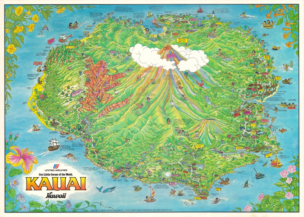
Kauai Hawaii, our little corner of the world (United Airlines).
1980 (dated) 23 x 32 in (58.42 x 81.28 cm)
1980 (dated) 23 x 32 in (58.42 x 81.28 cm)
Description
A rich and colorful 1980 pictorial view of Kauai, Hawaii, drawn by James Olson and published by Archar. It highlights the island's remarkable ecology, along with local landmarks, history, and communities.
A Closer Look
The island's interior, most of which is protected land, is dominated by volcanic peaks and dramatic canyons, including Mount Waialeale, 'the wettest spot on Earth.' It is also home to a space tracking station, towns and villages, golf courses, beaches, waterfalls, botanical gardens, museums, and important indigenous cultural sites. Figures and text throughout provide further information of historical or cultural importance.Forts and Firing Ranges
Illustrations and text refer to the area's history, including sites tied to struggles between the island's last independent ruler, Kaumualiʻi, and Kamehameha I in the early 19th century. The Russian-American Company became haphazardly entangled in this dispute and was granted a protectorate over Kauai, leading to the construction of Fort Elizabeth, in the foreground at left, along with two smaller forts. However, the forts did not prevent Kauai's incorporation into the Kingdom of Hawaii, and the Russians were expelled by Kamehameha I before Fort Elizabeth was completed. Much later, the U.S. military constructed the Pacific Missile Range Facility on Kauai, one of the most important facilities of its type in the U.S.Publication History and Census
This view was drawn by James Olson and published in 1980 by Archar (Western) Inc. in Minneapolis. It is not listed among the holdings of any institution.Cartographer
Archar / Travel Graphics (1973 - Present) is a Canadian and U.S. publishing company initially based in Toronto, Ontario. The firm is best known for its 'City Character Prints' - cartoonish view style maps intended to express the 'character' of a city. The firm employed a host of in house art directors, as well as a host of freelance illustrators. We find no trace of the company after 1983. Variants of the imprint include 'Archer Western' based in British Columbia and the St. Paul, Minnesota based 'Archar International'. Around 1984, the Minnesota firm was renamed Travel Graphics - Archer International, often printing under the 'Travel Graphics' imprint. Travel Graphics later relocated to Hawaii, where they remain active. More by this mapmaker...
Condition
Very good. Slight discoloration and creasing in bottom margin.