Digital Image: 1856 Kiepert Map of Lebanon
Lebanon-kiepert-1856_d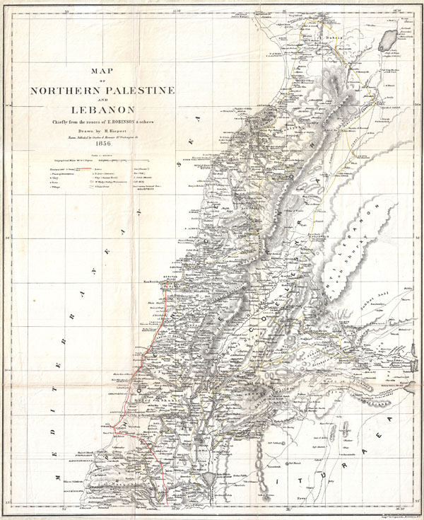

Title
Map of Northern Palestine and Lebanon Chiefly from the Routes of E. Robinson & others.
1856 (undated) 20 x 16.5 in (50.8 x 41.91 cm)
1856 (undated) 20 x 16.5 in (50.8 x 41.91 cm)
Description
FOR THE ORIGINAL ANTIQUE MAP, WITH HISTORICAL ANALYSIS, CLICK HERE.
Digital Map Information
Geographicus maintains an archive of high-resolution rare map scans. We scan our maps at 300 DPI or higher, with newer images being 600 DPI, (either TIFF or JPEG, depending on when the scan was done) which is most cases in suitable for enlargement and printing.
Delivery
Once you purchase our digital scan service, you will receive a download link via email - usually within seconds. Digital orders are delivered as ZIP files, an industry standard file compression protocol that any computer should be able to unpack. Some of our files are very large, and can take some time to download. Most files are saved into your computer's 'Downloads' folder. All delivery is electronic. No physical product is shipped.
Credit and Scope of Use
You can use your digial image any way you want! Our digital images are unrestricted by copyright and can be used, modified, and published freely. The textual description that accompanies the original antique map is not included in the sale of digital images and remains protected by copyright. That said, we put significant care and effort into scanning and editing these maps, and we’d appreciate a credit when possible. Should you wish to credit us, please use the following credit line:
Courtesy of Geographicus Rare Antique Maps (https://www.geographicus.com).
How Large Can I Print?
In general, at 300 DPI, you should at least be able to double the size of the actual image, more so with our 600 DPI images. So, if the original was 10 x 12 inches, you can print at 20 x 24 inches, without quality loss. If your display requirements can accommodate some loss in image quality, you can make it even larger. That being said, no quality of scan will allow you to blow up at 10 x 12 inch map to wall size without significant quality loss. For more information, it is best consult a printer or reprographics specialist.
Refunds
If the high resolution image you ordered is unavailable, we will fully refund your purchase. Otherwise, digital images scans are a service, not a tangible product, and cannot be returned or refunded once the download link is used.
Cartographer S
Heinrich Kiepert (July 31, 1818 - April 21, 1899) was a German cartographer and historian active in the mid to late 19th century. Kiepert was born into generous circumstances that allowed him to develop his childhood interest in geography and history into a serious profession. The Berlin-born Kiepert traveled widely in his youth, and was encouraged in his studies by the historian Leopold von Ranke, a family friend. He was a student of classical antiquity under August Meineke and worked with Cal Ritter. He studied history, philology, and geography at the Humboldt University of Berlin - he would eventually teach geography there, and would remain there until his death. Disappointed with the poor quality of maps in historical school books, Kiepert set out to correct the problem. His first major work, the Atlas von Hellas und den hellenischen Kolonien, was published with Karl Ritter in 1840. The work immediately won accolades from the academic community. A number of similar publications followed, including the 1848 Historisch-geographischer Atlas der alten Welt, the 1854 Atlas Antiquus, and the 1894 Formae Orbis Antiqui. Kiepert specialized in the historical geography of the classical world at the University of Berlin. This developed into a geographical interest in the Ottoman Empire - which at the time was poorly mapped. He traveled to Asia Minor four times between 1841 and 1848, using his travels to collect and compile geographical data, producing several outstanding regional maps with wide-ranging coverage extending from the Mediterranean to the Caucasus. Thanks in large part to these works, Kiepert became the recognized expert on Ottoman geography, his works representing the best obtainable reconnaissances of their respective regions. From 1845 until 1852, Kiepert served as the head of the Geographisches Institut in Weimar. In 1854 he took a position as professor of Geography at the University of Berlin and for nearly 50 years was considered the go-to man with regard to the cartography of classical and biblical antiquity. Kipert formed a long-lasting professional association with Dietrich Reimer, a publisher in Berlin. Kiepert's maps are known for b being clear, easy to read, and as accurate as possible for the time in which they were produced. In addition to his landmark work in mapping the Ottoman Empire, Kiepert also published the first detailed ethnic maps of Austria-Hungary, the Balkan Peninsula, and Germany. Kiepert died in Berlin on April 21 of 1899. More by this mapmaker...
Edward Robinson (1794-1863) was an American biblical scholar, known as the "Father of Biblical Geography". He has also been referred to, by scholar James Pritchard, as the "founder of modern Palestinology". Robinson was born in Connecticut and spent the year of 1838 exploring Palestine, Egypt, Syria and Jordan with fellow scholar the Reverent Eli Smith. His great work, Biblical Researches in Palestine and Adjacent Countries was awarded the Gold Medal of the Royal Geographical Society in 1842. In their travels Smith and Robinson identified a number of supposed biblical sites including a tunnel dug by Hezekiah before the Assyrian Siege of Jerusalem in 701-2 BC. His cartographic influence on map of the Holy Land was significant with several important American publishers including Colton and Johnson, updating their maps (and publishing new ones) with based upon his material. Learn More...
Eli Smith (1801-1857) was an American Protestant Missionary and scholar, born at Northford, Connecticut. He graduated from Yale in 1821 and from Andover Theological Seminary in 1826. He worked in Malta until 1829, then traveled through Armenia and Georgia to Persia in the company of H. G. O. Dwight. They published their observations, Missionary Researches in Armenia in 1833 in two volumes. Eli Smith settled in Beirut in 1833. In 1838, along with Edward Robinson, he made two trips to the Holy Land, acting as an interpreter for Robinson in his quest to identify and record Biblical place names in Palestine. He is known for bringing the first printing press with Arabic type to Syria. He went on to pursue his life's work: translation of the Bible into Arabic. Although he died before completing the translation, the work was completed by C. V. Van Dyck of the Syrian Mission and published in 1860. Learn More...
Source
Robinson, E., and Smith, E., Biblical Researches in Palestine, and in the Adjacent Regions. A Journal of Travels in the Year 1838. (Boston: Crocker & Brewster) 1856.