Digital Image: 1861 Sulman Panoramic Bird's Eye View of London
London-illustratedlondonnews-1861_d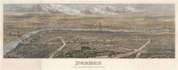

Title
London from the south side of the Thames.
1861 (dated) 22 x 53 in (55.88 x 134.62 cm)
1861 (dated) 22 x 53 in (55.88 x 134.62 cm)
Description
FOR THE ORIGINAL ANTIQUE MAP, WITH HISTORICAL ANALYSIS, CLICK HERE.
Digital Map Information
Geographicus maintains an archive of high-resolution rare map scans. We scan our maps at 300 DPI or higher, with newer images being 600 DPI, (either TIFF or JPEG, depending on when the scan was done) which is most cases in suitable for enlargement and printing.
Delivery
Once you purchase our digital scan service, you will receive a download link via email - usually within seconds. Digital orders are delivered as ZIP files, an industry standard file compression protocol that any computer should be able to unpack. Some of our files are very large, and can take some time to download. Most files are saved into your computer's 'Downloads' folder. All delivery is electronic. No physical product is shipped.
Credit and Scope of Use
You can use your digial image any way you want! Our digital images are unrestricted by copyright and can be used, modified, and published freely. The textual description that accompanies the original antique map is not included in the sale of digital images and remains protected by copyright. That said, we put significant care and effort into scanning and editing these maps, and we’d appreciate a credit when possible. Should you wish to credit us, please use the following credit line:
Courtesy of Geographicus Rare Antique Maps (https://www.geographicus.com).
How Large Can I Print?
In general, at 300 DPI, you should at least be able to double the size of the actual image, more so with our 600 DPI images. So, if the original was 10 x 12 inches, you can print at 20 x 24 inches, without quality loss. If your display requirements can accommodate some loss in image quality, you can make it even larger. That being said, no quality of scan will allow you to blow up at 10 x 12 inch map to wall size without significant quality loss. For more information, it is best consult a printer or reprographics specialist.
Refunds
If the high resolution image you ordered is unavailable, we will fully refund your purchase. Otherwise, digital images scans are a service, not a tangible product, and cannot be returned or refunded once the download link is used.
Cartographer S
Thomas Sulman (c.1834 – 1900) was an English architectural draftsman. Sulman studied at The Working Men’s College between 1854 and 1858, where he was a student of, and later an engraver for, Dante Gabriel Rossetti. He is best known for using balloons to capture birds-eye views of various cities including London, Oxford, Glasgow and New York. Most of his view were issued in association with the Illustrated London News and engraved by Robert Loudan Sr. In 1891 he produced high-level views of major London thoroughfares for Herbert Fry's London: Illustrated by Twenty Bird's Eye Views of the Principal Streets. These were engraved by George William Ruffle (1838–1901). In addition, Sulman prepared graphics for newspaper and magazine advertisements. More by this mapmaker...
Robert Loudan (fl. 1855 – 1895) was a prominent London woodcut engraver active in the middle part of the 19th century. Most of Loudan's work is associated with the Illustrated London News. His most prominent engravings were woodcuts based upon Thomas Sulman's dramatic balloon bird's-eye views of English and American cities. Considering the prominence of his work, it is surprising just how little biographical information exists. We know almost nothing of Loudan's life, education, or character. Learn More...
Illustrated London News (1842 - 1971) was one of the world's first weekly news magazines It was first published by Herbert Ingram and Mark Lemon (of Punch fame) in 1842. The lavishly illustrated magazine slowly gained popularity and continued to be published on a weekly basis until 1971. Today the Illustrated London News is the Illustrated London News Group and publishes bi-annually. Learn More...
Source
Illustrated London News, February 9, 1816.
References
Boston Public Library, Leventhal Center, G5754.L7A3 1861 .S85.