This item has been sold, but you can get on the Waitlist to be notified if another example becomes available, or purchase a digital scan.
1861 Stanford Pocket Map of London, England
London-stanford-1861$475.00

Title
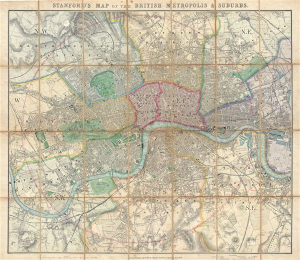
Stanford's Map of the British Metropolis & Suburbs.
1861 (dated) 25 x 28.25 in (63.5 x 71.755 cm)
1861 (dated) 25 x 28.25 in (63.5 x 71.755 cm)
Description
An extremely attractive 1861 pocket or case map of London, england, by edward Stanford. Centered on the Thames River, Stanford's folding case map covers central London from Holloway to Blackwall and from Dulwich to Brook Green. early in the Victorian era, London in the 1860s witnessed a period of massive growth, fueled by the Industrial Revolution, general prosperity, and immigration associated with its vast global empire. This, combined with construction of London's many railroads in the 1850s and the opening of the first Underground in 1863, led to the construction of numerous suburbs, growing London's footprint enormously in a relatively short period.
The map identifies all major streets, bridges, important buildings, gentlemanly estates, municipal buildings, taverns, parks, and the site of the 'International exposition.' The map is color coded according to district, with a circle centered on Charing Cross establishing a 4 mile radius. Stanford first issued this map in 1860 with the present example being the second edition updated to reflect the completion of the Victoria Railroad.
The map identifies all major streets, bridges, important buildings, gentlemanly estates, municipal buildings, taverns, parks, and the site of the 'International exposition.' The map is color coded according to district, with a circle centered on Charing Cross establishing a 4 mile radius. Stanford first issued this map in 1860 with the present example being the second edition updated to reflect the completion of the Victoria Railroad.
Cartographer
Edward Stanford (May 27, 1827 - November 3, 1904) was one of the most prolific map publishing firms of the late 19th century. The company began as a partnership in 1848 between the 21 year old Edward Stanford and the established map dealer Trelawney Saunders. By 1853 the partnership had dissolved and Edward Stanford took full control of the business. A subsequent series of expansions and exciting new map issues finally led to the production of Stanford's masterwork, "Stanford's Library Map of London". This map is still available and remains somewhat accurate. At the time of publishing it was hailed by the Royal Geographical Society as "the most perfect map of London that has ever been issued". In 1882 Edward Stanford Sr. passed the firm on to his son, Edward Stanford Jr. who continued in his father's proud tradition. Today the Stanford firm still publishes maps and remains one of the most important and prolific cartographic publishers in the world. More by this mapmaker...
Condition
Good. Verso repair to original linen backing. A couple of minor scrapes on recto.