This item has been sold, but you can get on the Waitlist to be notified if another example becomes available, or purchase a digital scan.
1753 Bowles and Carver View of London, England
LondonView-bowlescarver-1753$375.00

Title
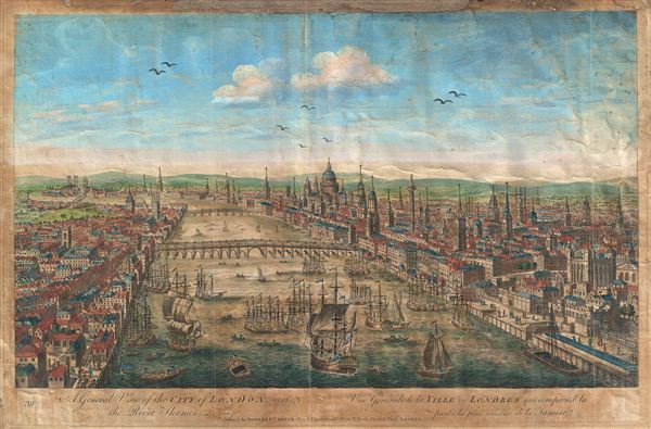
A General View of the City of London, next the River Thames. Vue Generale de la Ville de Londres qui comprend la partie la plus voisine de la Tamise.
1753 (undated) 11 x 17 in (27.94 x 43.18 cm)
1753 (undated) 11 x 17 in (27.94 x 43.18 cm)
Description
An attractive 1753 view of London set midstream on the Thames, looking west. Set amidst busy river commerce, this view shows London Bridge (foreground), Blackfriars Bridge (middle ground) and, around the bend, Westminster Bridge and Abbey. St. Paul's Church appears just to the right of Blackfriars Bridge. This view was printed by Carrington Bowles and Carver, 69 St. Paul's Church Yard, London, and listed in their 1753 catalogue under Perspective views in and about London. Another version was printed for C. Bowles' brother, John Bowles, located at Black Horse in Cornhill.1
Cartographer
The Bowles Family (fl. c. 1714 - 1832) were publishers and map sellers active in London from c. 1714 to c. 1832. The firm, under Thomas Bowles (fl. 1714 - 1763), John Bowles (1701 - 1779), Carrington Bowles (1724 - 1793), and as Bowles and Carver (fl. 1794 - 1832), produced a massive corpus of work that included numerous atlases, pocket maps, and wall maps. The Bowles publishing tradition was kept alive for four generations, starting with Thomas Bowles, a print engraver active in the late 17th century. His son, Thomas Bowles II, produced the firm's first maps at St. Paul's Churchyard, London. Thomas's brother, John Bowles (a.k.a. 'Old John Bowles' or 'Black Horse Bowles'), was also an active publisher established at no. 13 Cornhill. He is credited as one of the first publishers of William Hogarth's works. There, John's son, Carrington Bowles, was introduced to the trade. Carrington took over the Cornhill bookshop and eventually merged it with his uncle's shop in St. Paul's Churchyard. On Carrington's 1793 death, the business was passed to his son Henry Carrington Bowles (1763 - 1830), who partnered with his father's former apprentice Samuel Carver (1756 - 1841), renaming the firm 'Bowles and Carver'. Under this imprint, the firm continued to publish maps and atlases until 1832. Henry Carrington Bowles died in 1830, but Samuel Carver, himself in advanced years and poor health, kept it going for another 2 years before closing the business. More by this mapmaker...
Condition
Average. This view, while still attractive, shows clear signs of age, including several verso repairs, overall oxidization, and browning. Still, it remains highly attractive piece.
References
New York Public Library, Map Division, Map Div., Digital ID 1158215.