
Bowles Family

The Bowles Family (fl. c. 1714 - 1832) were publishers and map sellers active in London from c. 1714 to c. 1832. The firm, under Thomas Bowles (fl. 1714 - 1763), John Bowles (1701 - 1779), Carrington Bowles (1724 - 1793), and as Bowles and Carver (fl. 1794 - 1832), produced a massive corpus of work that included numerous atlases, pocket maps, and wall maps. The Bowles publishing tradition was kept alive for four generations, starting with Thomas Bowles, a print engraver active in the late 17th century. His son, Thomas Bowles II, produced the firm's first maps at St. Paul's Churchyard, London. Thomas's brother, John Bowles (a.k.a. 'Old John Bowles' or 'Black Horse Bowles'), was also an active publisher established at no. 13 Cornhill. He is credited as one of the first publishers of William Hogarth's works. There, John's son, Carrington Bowles, was introduced to the trade. Carrington took over the Cornhill bookshop and eventually merged it with his uncle's shop in St. Paul's Churchyard. On Carrington's 1793 death, the business was passed to his son Henry Carrington Bowles (1763 - 1830), who partnered with his father's former apprentice Samuel Carver (1756 - 1841), renaming the firm 'Bowles and Carver'. Under this imprint, the firm continued to publish maps and atlases until 1832. Henry Carrington Bowles died in 1830, but Samuel Carver, himself in advanced years and poor health, kept it going for another 2 years before closing the business.
Scarce, attractive English Map of Spain.
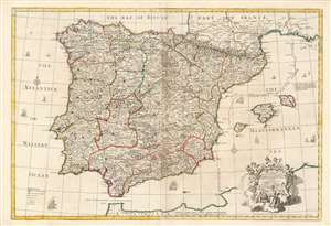
A Correct Map of Spain and Portugal According to the newest observations and discoveries comunicated to the Royal Society at London and the Royal Academy at Paris.
$850.00
Acquire
- Digital Map Information
- Suitable for large format printing
- Full resolution TIFF file
- ICC color profile embedded
- Delivered instantly via download link
This beautiful, large engraving is John Senex’s 1708 map of Spain and Portugal, covering the entire Iberian Peninsula, including the south of France, part of the north coast of Africa, the Strait of Gibraltar and the Balearic Islands of Ibiza, Majorca, and Minorca. It is attractively engraved, with decorative sailing ships and a baroque-inspired cartouche featuring a half-dozen putti wearing the classical iconography of the Greco-Roman gods (with a martial Mars front-and-center, and a commercial Mercury at top.) (more details)
First Modern Chart of the Solar System.
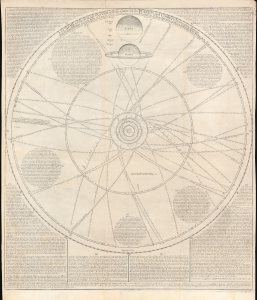
A scheme of the Solar System with the orbits of the planets and comets belonging thereto.
$6,500.00
Acquire
- Digital Map Information
- Suitable for large format printing
- File Size: 28.05 MB
- File Type: ZIP / TIFF
- ICC color profile embedded
- Delivered instantly via download link
This rare broadsheet engraving is a c.1763 Bowles edition of William Whiston's influential 1713 chart of the Solar System, including the orbits of known comets. It is the first modern chart of the Solar System, incorporating the observations of Newton, Halley, and Flamsteed. (more details)
First large-scale map to show American postal routes.
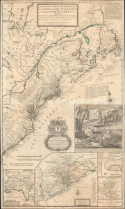
A New and Exact Map of the Dominions of the King of Great Britain on ye Continent of North America. Containing Newfoundland, New Scotland, New England, New York, New jersey, Pensilvania, Maryland, Virginia and Carolina.
$11,000.00
Acquire
- Digital Map Information
- Suitable for large format printing
- File Size: 44.83 MB
- File Type: ZIP / TIFF
- ICC color profile embedded
- Delivered instantly via download link
This is Herman Moll's 1715 'Beaver Map' of the British Colonies in America, here in its 1733 state (see below). In addition to its iconic and namesake image of Niagara Falls and the rich American peltries, this map is also significant as one of the most accurate maps of the period and the first large-scale map to show American postal routes. (more details)
Tower of London, London Bridge, St. Paul's, and Westminster Abbey.
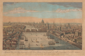
A General View of the City of London next the River Thames. Vüe Générale de la Ville de Londres, du côté de la Tamise.
$850.00
Acquire
- Digital Map Information
- Suitable for large format printing
- File Size: 9.76 MB
- File Type: ZIP / TIFF
- ICC color profile embedded
- Delivered instantly via download link
This is a charming 1751 Thomas Bowles and Robert Sayer bird's-eye view of London as the beating heart of a global empire. (more details)
Seminal view of Quebec shortly after the French and Indian War.
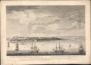
A View of the City of Quebec, the capital of Canada, taken partly from the Pointe des Peres, and partly on Board the Vanguard Man of War. / Vue de la Ville de Québec, capitale du Canada, prise en partie de la Pointe des Peres, et en partie abord de l'Avantgarde Vaisseau de Guerre.
$5,500.00
Acquire
- Digital Map Information
- Suitable for large format printing
- File Size: 25.18 MB
- File Type: ZIP / TIFF
- ICC color profile embedded
- Delivered instantly via download link
This is the rare 1868 Hervey Smyth view of Quebec City, published in 1768. It is one of the earliest obtainable views of Quebec City, offering a look at the city shortly after the French and Indian War (1754 - 1763). The view was published for the Scenographia Americana, one of the most influential and monumental pre-Revolutionary graphic works on North America. (more details)
Capital of New England - one of the earliest views of Boston based on actual observation.

A View of the City of Boston the Capital of New England, in North America. / Vue de la Ville de Boston Capitale de la Nouvelle Angleterre, dans l'Amérique Septentrionale.
$6,500.00
Acquire
- Digital Map Information
- Suitable for large format printing
- File Size: 29.58 MB
- File Type: ZIP / TIFF
- ICC color profile embedded
- Delivered instantly via download link
This is the rare Thomas Pownall view of Boston, published in 1768. It is one of the earliest obtainable views of Boston, offering a glimpse of the city shortly after the French and Indian War (1754-1763). (more details)
On the cusp of the American Revolutionary War.
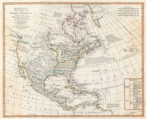
Bowles's New Pocket-Map of North America, Divided into it's Provinces, Colonies, etc,. by J. Palairet, Geographer; lately Revised and Improved with Many Additions from D'Anville, Mitchell, and Bellin, by L. Delarochette.
$2,500.00
Acquire
- Digital Map Information
- Suitable for large format printing
- DPI: 600
- File Size: 46.4 MB
- File Type: ZIP / TIFF
- ICC color profile embedded
- Delivered instantly via download link
This is a c. 1771 Carington Bowles map of North America, published just 4 years prior to the American Revolutionary War (1775 - 1783). The map depicts the increasingly complex and unstable political situation following the French and Indian War (1754 - 1763). It further illustrates ambitions for an inland Northwest Passage via Hudson Bay, and speculations about a great 'Sea of the West' dominating the Pacific Northwest - one of the last and greatest cartographic myths of the 18th century. (more details)
Piracy of a seminal map detailing Trans-Appalachia.
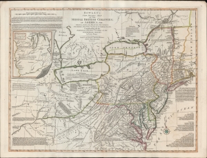
Bowles's New Pocket Map of the Middle British Colonies, in America, Vis. Virginia, Maryland, Delaware, Pensylvaia, New Jersey, New York, Connecticut and RHode Island. Comprending also the Habitations and Hunting Countries of the Confederate Indians: by Lewis Evans.
$6,500.00
Acquire
- Digital Map Information
- Suitable for large format printing
- DPI: 600
- File Size: 659.83 MB
- File Type: ZIP / TIFF
- ICC color profile embedded
- Delivered instantly via download link
A fine example of the 1780 Carington Bowles edition of the Lewis Evans map of the Middle British Colonies - one of the most important maps to emerge out of the French and Indian War (1754 - 1763). Essentially a piracy of a piracy, this is the Carington Bowles 1780 piracy of the 1771 Kitchen/Jefferys piracy of the 1755 Lewis Evans map - here given new relevance in the context of the American Revolutionary War (1775 - 1783). There are numerous subtle changes over earlier editions although the essential Lewis Evans chart - the finest and most comprehensive treatment of the Trans-Appalachia and the Ohio Valley from the French and Indian War through the Revolutionary period - remains the core. Pre-release editions of this map were circulated among British officers, including Major-General Edward Braddock (1695 - 1755), who consulted them during his disastrous 1755 expedition against the French-occupied Ohio River Valley (he was killed in the effort - but not for lack of cartographic reconnaissance). (more details)
Bowles's map of the Americas before American independence.
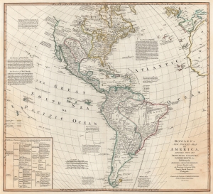
Bowles's New Pocket-Map of America, Divided into its Provinces, Colonies, Governments, etc. Exhibiting the British and Spanish Empires therein; Together with the Territories belonging to the French, Dutch, Danes, and Portuguese.
$2,950.00
Acquire
- Digital Map Information
- Suitable for large format printing
- DPI: 600
- File Size: 48.74 MB
- File Type: ZIP / TIFF
- ICC color profile embedded
- Delivered instantly via download link
This is a c. 1780 Carington Bowles map of North America and South America. The map depicts the increasingly complex and unstable political situation following the French and Indian War (1754 - 1763). It also highlights French and English ambitions for an inland Northwest Passage via Hudson Bay and speculations about a 'Sea of the West' dominating the Pacific Northwest - one of the last and greatest cartographic myths of the 18th century. (more details)
Decoratve map of the world from the American Revolutionary War Period.
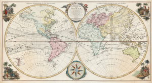
Bowles's New Pocket Map of the World, laid down from the latest observations and comprehending the New Discoveries to the present Time, particularly those lately made in the Southern Seas By Byron, Wallis, Cook, Bougainville, and others.
$1,800.00
Acquire
- Digital Map Information
- Suitable for large format printing
- DPI: 600
- File Size: 56.82 MB
- File Type: ZIP / TIFF
- ICC color profile embedded
- Delivered instantly via download link
This is a strikingly decorative 1780 Carington Bowles English-language double-hemisphere map of the world at the height of the Georgian Era and the American Revolutionary War (1775 - 1783). The map captures the political and geographical assumptions of the late 18th century, including a number of curiosities and cartographic anomalies, all from a distinct British perspective. (more details)
All roads lead to London.
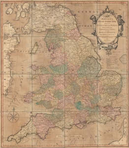
Bowles's road director through England and Wales; being a new and comprehensive display of the roads and distances from town to town, and of each remarkable place from London.
$750.00
Acquire
- Digital Map Information
- Suitable for large format printing
- Full resolution TIFF file
- ICC color profile embedded
- Delivered instantly via download link
An impressive 1800 Bowles and Carver map highlighting the system of roads of England and Wales, including the dense network emanating from London. (more details)