1822 Jacotin Wall Map of Lower Egypt
LowerEgypt-jacotin-1822$550.00


Title
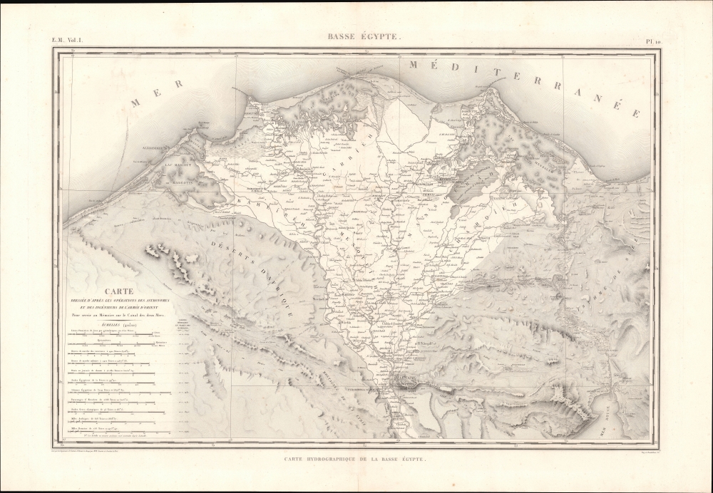
E. M. Vol. I. Pl. 10. Basse Égypte. Carte hydrographique de la Basse Égypte.
1822 (undated) 24 x 34 in (60.96 x 86.36 cm) 1 : 400000
1822 (undated) 24 x 34 in (60.96 x 86.36 cm) 1 : 400000
Description
This is a c. 1822 Pierre Jacotin and Gratien Le Père map of Lower Egypt and the Nile River Delta, prepared for the monumental work Description de l'Égypte.
The map's subtitle refers to an ancient canal (most often known as 'the Canal of the Pharaohs' and labelled here as 'Vestiges du Canal de Suez') starting east of the ancient city of Bubastis (here as 'Bubaste runiée'), that was an ancient forerunner to the Suez Canal. The Ancient Greeks believed that the canal was built by Senusret III (Sesostris to the Greeks), who ruled in the 19th century BCE (the Twelfth Dynasty of the Middle Kingdom), but it most likely was not built until over a millennium later, completed in the reign of Darius the Great (r. 550 - 486 BCE) during the era of Achaemenid rule of Egypt. Later rulers of Egypt, including the Ptolemaic Dynasty, the Roman emperors Trajan and Diocletian, and early Arabs attempted to maintain the canal, but it proved difficult to do so over an extended period of time due to its tendency to, like the Nile, silt up. When Napoleon invaded Egypt, he was keen on finding the remnants of the ancient canal and tasked a group of scientists, surveyors, and engineers with locating it, which they were able to do with some accuracy, with their findings, including this map, ending up in the Description de l'Égypte. For his part, Napoleon later considered building a modern canal linking the Mediterranean and Red Sea but was dissuaded by a common but mistaken belief that there was a significant difference in sea levels between the two.
Where the campaign failed in its military ambitions, it was a great success scientifically. Military topographers completed the most sophisticated survey of Egypt yet undertaken. More than 60 civilian scholars and scientists, known popularly as 'the Savants', compiled archeological, botanical, geological, and zoological data. Most significantly, the expedition brought the Rosetta Stone to light, effectively creating the new field of Egyptology.
A Closer Look
The map covers the Nile River Delta in Lower Egypt, as far south as Cairo, Giza, Memphis, and Suez. The many tributaries, canals, lakes, and other waterways of the delta are labelled, along with a remarkable number of settlements, dried former waterways, ancient ruins, routes through the deserts on either side of the delta (including those taken by Napoleon's soldiers), caravanserai, churches and religious convents, mountains, and other features. Eleven scales of ancient and modern units of measure appear at bottom-left.The map's subtitle refers to an ancient canal (most often known as 'the Canal of the Pharaohs' and labelled here as 'Vestiges du Canal de Suez') starting east of the ancient city of Bubastis (here as 'Bubaste runiée'), that was an ancient forerunner to the Suez Canal. The Ancient Greeks believed that the canal was built by Senusret III (Sesostris to the Greeks), who ruled in the 19th century BCE (the Twelfth Dynasty of the Middle Kingdom), but it most likely was not built until over a millennium later, completed in the reign of Darius the Great (r. 550 - 486 BCE) during the era of Achaemenid rule of Egypt. Later rulers of Egypt, including the Ptolemaic Dynasty, the Roman emperors Trajan and Diocletian, and early Arabs attempted to maintain the canal, but it proved difficult to do so over an extended period of time due to its tendency to, like the Nile, silt up. When Napoleon invaded Egypt, he was keen on finding the remnants of the ancient canal and tasked a group of scientists, surveyors, and engineers with locating it, which they were able to do with some accuracy, with their findings, including this map, ending up in the Description de l'Égypte. For his part, Napoleon later considered building a modern canal linking the Mediterranean and Red Sea but was dissuaded by a common but mistaken belief that there was a significant difference in sea levels between the two.
Napoleon in Egypt
The French campaign in Egypt and Syria (1798 - 1801) was fought between the forces of Napoleon Bonaparte and Ottoman armies in Egypt and Syria. Napoleon proclaimed his invasion of Egypt to defend French trade interests and to complete a scientific study of the region. He also hoped that seizing Egypt and Syria would destabilize British influence in the region, weakening British access to India, and encourage an alliance with Tipu Sultan, who was actively fighting against the British in India. Despite initial military successes, the campaign floundered when British Admiral Horatio Nelson sunk the French fleet at the Battle of Aboukir Bay (1798). Without naval backup and resupply, the French forces were forced to fight a hard overland campaign that ultimately cost more than it gained and ended in the complete French withdrawal from Egypt.Where the campaign failed in its military ambitions, it was a great success scientifically. Military topographers completed the most sophisticated survey of Egypt yet undertaken. More than 60 civilian scholars and scientists, known popularly as 'the Savants', compiled archeological, botanical, geological, and zoological data. Most significantly, the expedition brought the Rosetta Stone to light, effectively creating the new field of Egyptology.
Publication History and Census
This map was prepared by army engineers Pierre Jacotin and Gratien Le Père during Napoleon's campaign in Egypt, then engraved for inclusion in the Description de l'Égypte a colossal and richly illustrated multivolume work published by the French government that gathered all the knowledge of the region's natural and human history, from antiquity to the then-present. The work was produced by a team of dozens of scholars and technical experts, as well as hundreds of artists and engravers (see 'Source' section below for more information). This example, engraved by Vicq et Dandeleux, appeared in the second edition of the work, published by Charles Louis Fleury Panckoucke between 1821 and 1830. Like other individual plates from the Description de l'Égypte it is quite rare, though a full census is difficult given the complex publication history of the entire work. This map is individually cataloged by the Bibliothèque nationale de France and Bayerische Staatsbibliothek, and is also held by the David Rumsey Historical Map Collection.Cartographer
Pierre Jacotin (April 11, 1765 - 1827) was a French geographer and military cartographer active in Egypt and France during the late 18th and early 19th centuries. Jacotin was born in Champigny-lès-Langres (Haute-Marne). He assisted his uncle. Dominique Testervuide in completing the first large scale land plan of Corsica in 1770. Both Jacotin and his Uncle were assigned to the Armée d'Orient for Napoleon's 1798 invasion of the Middle East and Egypt. His uncle, Dominique Testevuide (1735 - 1798), was assassinated during the October 21, 1798 Cairo Revolt. Afterwards, in 1799, Jacotin was named director of all the surveyors and geographers working in the Nile Valley. After his return from Egypt, Jacotin was assigned to the Dépôt de la Guerre and worked on preparing the manuscript maps of the Egypt Expedition for publication in a grand folio atlas volume connected to the Description de l'Égypte. In 1808 Napoleon formally made the geographic records of the Egypt Campaign, the finest maps of Egypt yet compiled, state secrets and put them under censure. It was not until 1817, after the Bourbon Restoration, that the maps were finally published as volume 23 of the Imperial Edition of Description de l'Égypte. More by this mapmaker...
Source
Description de l'Égypte (Paris) 1809 - 1823.
The Description de l'Égypte was the most exhaustive study of Egypt produced during the 19th century. The study was ordered by French Emperor Napoleon Bonaparte in conjunction with his 1798 - 1801 expedition to Egypt. It is the product of immense scholarship in all areas and is the collaborative accomplishment of some 160 civilian scholars and scientists, known popularly as 'The Savants.' There are two editions. The first edition is known as the 'Imperial Edition' and features 23 volumes issued between 1809 and 1823. The second edition, known as the Panckoucke Edition, containing 37 volumes, was issued between 1821 and 1829. Both editions include an elephant folio atlas volume containing a detailed survey of Egypt on a uniform scale of 1:100000. In 1808 Napoleon formally made the geographic records of the Egypt Campaign, the finest maps of Egypt yet compiled, state secrets and put them under censure. It was not until 1817, after the Bourbon Restoration, that the maps were finally published as volume 23 of the Imperial Edition of Description de l'Égypte. This is the most significant atlas of Egypt produced in the 19th century and is a monumental historic, cartographic, and scientific achievement. It is believed that only 1000 copies were printed, most of which went to institutional collections and so all associated maps and prints are of the utmost scarcity.
Condition
Very good. Light soiling and foxing. Some wear to centerfold at bottom margin.
References
Rumsey 10404.449. OCLC 494369627, 165498597.