Digital Image: 1840 Vincendon-Dumoulin Nautical Map of the Loyalty Islands
LoyaltyIslands-vincendondumoulin-1847_d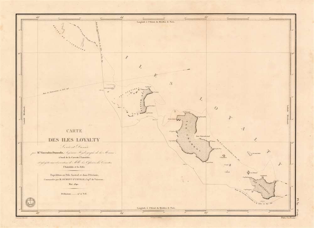

Title
Carte des Iles Loyalty Levée et Dressée par Mr. Vincendon-Dumoulin, Ingenieur Hydrographe de la Marine.
1847 (dated) 17 x 23 in (43.18 x 58.42 cm) 1 : 559500
1847 (dated) 17 x 23 in (43.18 x 58.42 cm) 1 : 559500
Description
FOR THE ORIGINAL ANTIQUE MAP, WITH HISTORICAL ANALYSIS, CLICK HERE.
Digital Map Information
Geographicus maintains an archive of high-resolution rare map scans. We scan our maps at 300 DPI or higher, with newer images being 600 DPI, (either TIFF or JPEG, depending on when the scan was done) which is most cases in suitable for enlargement and printing.
Delivery
Once you purchase our digital scan service, you will receive a download link via email - usually within seconds. Digital orders are delivered as ZIP files, an industry standard file compression protocol that any computer should be able to unpack. Some of our files are very large, and can take some time to download. Most files are saved into your computer's 'Downloads' folder. All delivery is electronic. No physical product is shipped.
Credit and Scope of Use
You can use your digial image any way you want! Our digital images are unrestricted by copyright and can be used, modified, and published freely. The textual description that accompanies the original antique map is not included in the sale of digital images and remains protected by copyright. That said, we put significant care and effort into scanning and editing these maps, and we’d appreciate a credit when possible. Should you wish to credit us, please use the following credit line:
Courtesy of Geographicus Rare Antique Maps (https://www.geographicus.com).
How Large Can I Print?
In general, at 300 DPI, you should at least be able to double the size of the actual image, more so with our 600 DPI images. So, if the original was 10 x 12 inches, you can print at 20 x 24 inches, without quality loss. If your display requirements can accommodate some loss in image quality, you can make it even larger. That being said, no quality of scan will allow you to blow up at 10 x 12 inch map to wall size without significant quality loss. For more information, it is best consult a printer or reprographics specialist.
Refunds
If the high resolution image you ordered is unavailable, we will fully refund your purchase. Otherwise, digital images scans are a service, not a tangible product, and cannot be returned or refunded once the download link is used.
Cartographer S
Clément Adrien Vincendon-Dumoulin (March 4, 1811 - May 12, 1858) was a French Naval hydrographer and engineer. Among other voyages, he took part in the Dumont d'Urville expedition in Antarctica, during which he made the first calculation allowing to locate the magnetic South Pole on January 23, 1838. He was educated at the École Polytechnique in 1831, and upon completion of his education joined the surveyors engineers of the Navy. Between 1834 and 1836 he participated in the regular survey of the western coasts of France. In 1837 Admiral Ferdinand Hamelin recommended him to Dumont d'Urville as 'a wise and industrious man who will do us a good job', and as a result was appointed to embark as hydrographer on L'Astrolabe for its second journey under Dumont d'Urville, accompanied by the ship Zélée. It was during this navigation of more than 3 years that Adélie Land in Antarctica ) Vincendon-Dumoulinhe was credited as the first Frenchman to see Antarctica, having climbed the rigging to do so. During the expedition's return via the Pacific, he executed maps of many of the ill-charted islands the two ships encountered. Vincendon-Dumoulin made a point of calculating the longitude and latitude of each stopover. For coasts at which he was unable to disembark, he improved processes of measuring and drawing them without having predetermined points available for reference - allowing the execution of maps while under sail: a great advantage in naval intelligence gathering. Dumont d'Urville would go on to praise the hydrographer in his history of the voyage, saying the appointment of its hydrographer 'served me beyond all my expectations'. His fame was such that Jules Verne, in 'Twenty Thousand Leagues Under the Sea' would have his Captain Nemo praise 'the excellent maps of the Torres Strait drawn up and drawn up by the hydrograph engineer Vincendon-Dumoulin.' More by this mapmaker...
Chassant (fl. c. 1830 - 1860) was a French line and chart engraver active in Paris in the middle part of the 19th century. Chassant was active with the French Dépôt de Marine from the 1830s into the 1860s. He was a master engraver and, some have argued, his dramatic hachuring work to illustrate topography suggests he may have been wasted on nautical charts. Most of his engraving was completed in partnerships with Jacques-Marie Hacq (September 22, 1785 – 18??). Chassant did not sign any of his engravings with a first name or other identifier, so it is difficult to track him down. He may be Alphonse Antoine Louis Chassant (August 1, 1808 - September 7, 1907), who in later life was an art historian and librarian of the city of Évreux. He wrote several books, including works on engraving. We cannot alas verify the connection and it may be pure guesswork. Learn More...
Jacques-Marie Hacq (September 22, 1785 – 18??) was a French letter and line engraver, and historian, active in Paris during the middle part of the 19th century. Hacq was born in Paris and trained under J. P. Besançon, who he succeeded at the Dépôt de la Guerre in 1830. He engraved for the Dépôt de la Guerre as early as 1830 and for the Dépôt des Cartes et Plans de la Marine from, at least, 1840 to 1852. In addition to his work for the French Government, he also completed maps and engravings for Lesage, Lapie, Dufour, Duperrez, Gouvion St. Cyr, and Dumont d'Urville. His historical works include a history of the Napoleonic Wars and a history of Paris under the reign of Louis XIII. During most of his career in Paris he lived at 58 Rue de la Harpe. Learn More...
Source
Dumont d'Urville, J. Voyage au pole sud et dans l'Océanie sur les corvettes l'Astrolabe et la Zélée, (Paris) 1747.
References
OCLC 556447860.