This item has been sold, but you can get on the Waitlist to be notified if another example becomes available, or purchase a digital scan.
1734 Separately-issued Seutter Plan and View of Luxembourg City
Luxembourg-seutter-1734$750.00

Title
Luxembourg, une Fortresse tres celebre de la Duché de cette Nom dans Pais-bas. Grave par M. Seutter, S.C.M. Geogr.
1734 (undated) 19 x 22 in (48.26 x 55.88 cm) 1 : 7000
1734 (undated) 19 x 22 in (48.26 x 55.88 cm) 1 : 7000
Description
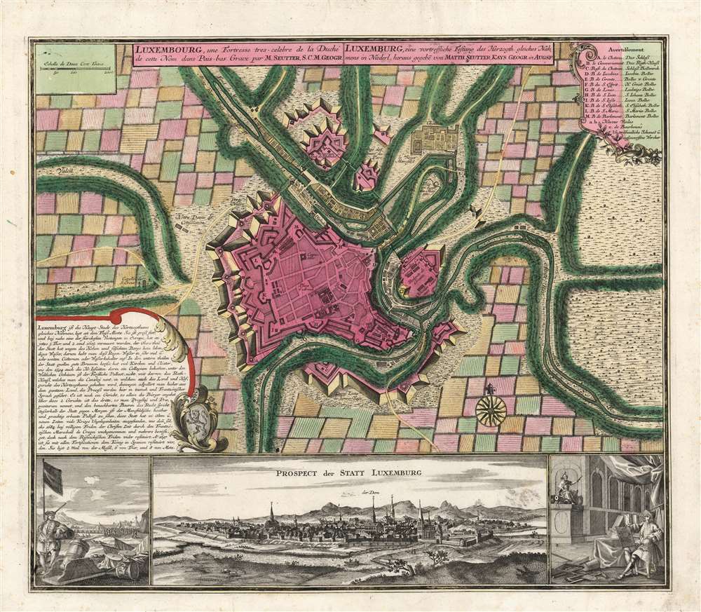
This is as beautiful, rare, separately issued plan and view of the city of Luxembourg by Matthias Seutter, c. 1734. It illustrates the situation of the fortified city during the renovation of its defenses in the 1730s.
Historical Context
These renovations were executed by the Austrian Habsburgs, whose rule over the city and the Duchy of Luxembourg was confirmed by treaty in the aftermath of the War of the Spanish Succession (1701 - 1714). The Duchy passed back and forth between the French, the Spanish, and the Austrians for many years. As each successive regime took possession, conquerors added to the defenses in an effort to preserve it from attack. Most notably, the distinctive walls instituted by the famed French military engineer Marquis de Vauban, whose fortifications are plainly visible on the map and remain today. Vauban's defenses were augmented under Austrian rule in the 1730s, as visible here.The Map
The upper portion of the engraving is a city plan, whose most notable features are the modern fortifications. A legend at the top right names buildings indicated by letters on the plan, while other parts of the fortifications are identified by name within the body of the engraving. At the lower left, within an ornamental frame, is a descriptive text regarding the city's location and defensibility, as well as its churches and palaces - oddly, these include the Mansfeld Palace (also known as La Fontaine Castle).The Views
Three engraved views decorate the bottom of the map. At the lower left is a scene of one of the many sieges withstood by Luxembourg. The city walls can be seen in the background, while in the foreground, a soldier leans on a cannon with a musket on his shoulder. Beside him, in some disarray, are canons, tent material, and a siege mortar. In the middle distance, soldiers are at drill. At the lower right, a seated gentleman surrounded by surveyors' tools displays his work: a plan for the fortress depicted on the map itself. (Is this the famed Marquis de Vauban, or a later engineer under Austria's Charles VI?) Whomever it is, he cocks an eye at the figure in the upper left-hand corner of the view: hirsute, helmeted, brandishing a sword, and seated on a cannon, this can only be Ares, the god of war. (We criticize this choice of patron: it seems that Athena, the goddess of wisdom in war, would have been more apropos, but alas.) The reputation of the strength of the city's defenses remained long after this piece was printed. During the French Revolutionary Wars, the city held out after a seven-month siege, leading French politician and military engineer Lazare Carnot to declare Luxembourg 'the best fortress in the world, except Gibraltar.'Publication History and Census
This engraving appeared in Seutter's 1734 Grosser Atlas, but the present example appears to have been a separately issued copy, given the absence of any centerfold. We know only one example to have come on the market in the past fifteen years. There are sixteen examples in institutional collections.Cartographer
Matthäus Seutter (1678 - 1757) was one of the most important and prolific German map publishers of the 18th century. Seutter was born the son of a goldsmith but apprenticed as a brewer. Apparently uninspired by the beer business, Seutter abandoned his apprenticeship and moved to Nuremberg where he apprenticed as an engraver under the tutelage of the prominent J. B. Homann. Sometime in the early 1700s Seutter left Homann to return to Augsburg, where he worked for the prominent art publisher Jeremiad Wolff (1663 - 1724), for whom he engraved maps and other prints. Sometime around 1717 he established his own independent cartographic publishing firm in Augsburg. Though he struggled in the early years of his independence, Seutter's engraving skill and commitment to diversified map production eventually attracted a substantial following. Most of Seutter's maps are heavily based upon, if not copies of, earlier work done by the Homann and De L'Isle firms. Nonetheless, by 1731/32 Seutter was one of the most prolific publishers of his time and was honored by the German Emperor Karl VI who gave him the title of Imperial Geographer, after which most subsequent maps included the Avec Privilege designation. Seutter continued to publish until his death, at the height of his career, in 1757. Seutter had two engraver sons, Georg Matthäus Seutter (1710 - 173?) and Albrecht Carl Seutter (1722 - 1762). Georg Matthäus quit the business and relocated to Woehrdt in 1729 (and probably died shortly thereafter), leaving the family inheritance to his wastrel brother Albrecht Carl Seutter, who did little to advance the firm until in own death in 1762. Following Albrecht's death, the firm was divided between the established Johann Michael Probst (1727 - 1776) firm and the emerging firm of Tobias Conrad Lotter. Lotter, Matthäus Seutter's son-in-law, was a master engraver and worked tirelessly on behalf of the Suetter firm. It is Lotter, who would eventually become one of the most prominent cartographers of his day, and his descendants, who are generally regarded as the true successors to Matthäus Seutter. (Ritter, M. Seutter, Probst and Lotter: An Eighteenth-Century Map Publishing House in Germany., "Imago Mundi", Vol. 53, (2001), pp. 130-135.) More by this mapmaker...
Source
Seutter, M., Grosser Atlas, (Augsburg: Seutter), 1734.
Condition
Excellent. A superb strike with rich original color.
References
OCLC 935366733.