1848 Marie Adélaïde Delisle (Veuve Turgis) City Plan or Map of Lyon, France
Lyon-mariedelisle-1848$600.00


Title
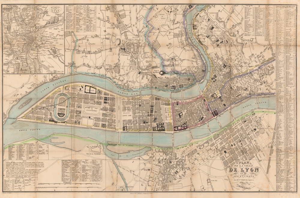
Plan de la ville de Lyon et de ses environs.
1848 (undated) 22.5 x 34.75 in (57.15 x 88.265 cm) 1 : 6000
1848 (undated) 22.5 x 34.75 in (57.15 x 88.265 cm) 1 : 6000
Description
This is a Marie Adélaïde Delisle (Veuve Turgis) c. 1848 city plan or map of Lyon, France - one of only a few 19th century maps issued by a female cartographer. Situated at the confluence of the Rhône and Saône rivers, Lyon is the second largest city in France and is recognized as a gastronomical hub of France. The Presqu'île appears in detail with buildings and bridges illustrated.
A Closer Look
Depicting central Lyon, buildings throughout are labeled, including churches, hospitals, warehouses, military installations, forts, and the hippodrome. Streets, squares, and the railroad are identified. An alphabetic street index appears along the right border, providing grid locations for streets. A second index, in the upper left lists avenues, markets, seminaries, city gates, and piers. An index of hospitals, public buildings, bridges, churches, and convents occupies part of the lower left, along with extensions for the indexes from 1844 and 1848.Historical Context - The Revolution of 1848
This map appeared at a dynamic time in French history. On February 22, 1848, the French people protested the government of François Guizot, which, by the end of the day, had devolved into a popular revolt. French troops dispersed the protesters, but by evening they regrouped and barricaded themselves in southeast Paris. There were skirmishes in Paris that night between protesters and the Municipal Guard. Guizot resigned as prime minister the following day, and everyone thought the unrest was at an end. However, at around 9:30 that night, a crowd of over 600 people assembled around the Ministry of Foreign Affairs and began pressing in on the soldiers guarding the building. While the soldiers were fixing bayonets to keep the crowd at bay, an unknown gun went off. This caused the soldiers to fire into the crowd, killing 52 and wounding 74. This massacre angered Parisians, who again manned the barricades. By morning on February 24, 1,500 barricades had been erected throughout Paris and many of the railways into the city had been sabotaged. Intense fighting broke out in several parts of the city that morning and insurgents set fire to the Château d'Eau, a guard post near the Tuileries Palace. By noon King Louis Philippe had abdicated, officially ending the July Monarchy. The February Revolution, as it became known, resulted in the founding of the French Second Republic. It also rippled across Europe, causing a wave of mostly failed insurgencies known as the Revolutions of 1848. These occurred in the Italian States, the Greman States, Denmark, the Austrian Empire, Sweden, Switzerland, Poland, Romania, Belgium, Spain, and the United Kingdom. The fervor spread outside of Europe as well, reaching Canada and Latin America.Publication History and Census
This map was created by an artist known only as Pelicier, engraved by J. B. Tardieu (Jean-Baptiste Pierre Tardieu died at least five years before this map was published, and with the updates with information to 1844 and 1848 it must be a different J. B. Tardieu), printed by Delarue in Paris, and published by Marie Adélaïde Delisle (Veuve Turgis) c. 1848. We note two examples cataloged in OCLC that may correspond with the present map: Bibliothèque nationale de France and the Université Toulouse 1 Capitole. Veuve Turgis published at least two subsequent editions: one dated 1849 and another in 1853.Cartographer
Marie Adélaïde Delisle (July 13, 1788 - December 5, 1856) was a French editor and publisher. Born in Linverville, France, Delisle helped on her family farm until she married Jean-Baptiste Louis Turgis in 1813. Turgis bought a Paris-based print selling business in 1813 or 1814 and spent most of the first years of their marriage in Paris building up the business, while Marie stayed in Gouville-sur-Mer and became a spinner to help pay the bills. Marie had both their children in Gouville during times when her husband was in Paris. Finally in 1819 or 1820 the family moved to Paris. Jean-Baptiste died on July 23, 1825, and Marie took over the printing business, founding the publishing house Veuve Turgis in 1828. Delisle ran the business and was very successful, opening offices in Toulouse, France, and New York, United States. The business published maps, but their most popular products were Christian images, such as portraits of saints and first communion stamps. She passed the business on to her son Louis Turgis in 1855 and died in Paris in December 1856. More by this mapmaker...
Condition
Good. Verso repairs to fold separations and at fold intersections. Slight loss at a few fold intersections. Top left panel reattached near fold lines.
References
OCLC 1151627905.