1846 Bradford Map of Maine, with Recent Territorial Changes
Maine-bradford-1846-2$350.00

Title
Maine.
1846 (dated) 14.5 x 11.5 in (36.83 x 29.21 cm) 1 : 1584000
1846 (dated) 14.5 x 11.5 in (36.83 x 29.21 cm) 1 : 1584000
Description
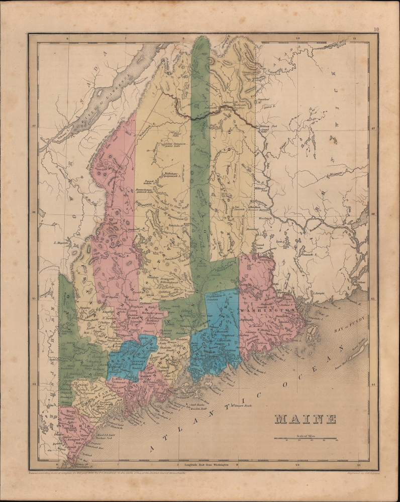
An example of Thomas Bradford's 1846 map of Maine, published in his Universal Illustrated Atlas.
A Closer Look
Coverage embraces Maine, with numerous cities and towns identified. The lakes in the northern parts of the state are especially noteworthy, as here they retain Native American names, many of which were later changed. The railroad from Kittery to Portland is illustrated, as is the short line between Bangor and Orono (in fact extending to Old Town), the first in Maine and one of the first in the United States. The most intriguing element illustrated here reflects the changes to the border between Maine and British Canada established by the Webster-Ashburton Treaty.The Aroostook War and the Webster-Ashburton Treaty
The Webster-Ashburton Treaty ended the nearly bloodless Aroostook War (Pork and Beans War) and fixed the border between Maine and British Canada. The dispute over 13,000 square miles of land between modern-day Quebec and New Brunswick erupted over logging rights. This war, between British colonies in Canada, and American forces in the state of Maine, really should be called an international incident. There were no deaths, but two Canadian militiamen were injured, and several Brits were taken prisoner, but there were no significant engagements. The treaty, signed by U.S. Secretary of State Daniel Webster and British diplomat Alexander Baring, 1st Baron Ashburton, in August 1842, gave the United States over half of the disputed territory. Here, Bradford illustrates the newly agreed-upon border (noted as 'line proposed by the King of the Netherlands,' that is, William I, who attempted to arbitrate the dispute in the early 1830s), along with the 'line claimed by Great Britain' and the 'boundary according to the Treaty of 1783'.Publication History and Census
This map was engraved by George Washington Boynton and, despite the date of the copyright at bottom-left, was published in the 1846 edition of Bradford and Goodrich's A Universal Illustrated Atlas.CartographerS
Thomas Gamaliel Bradford (1802 - 1887) was born in Boston, Massachusetts, where he worked as an assistant editor for the Encyclopedia Americana. Bradford's first major cartographic work was his revision and subsequent republishing of an important French geography by Adrian Balbi, Abrege de Geographie published in America as Atlas Designed to Illustrate the Abridgment of Universal Geography, Modern and Ancient. Afterwards Bradford revised and expanded this work into his own important contributions to American cartography, the 1838 An Illustrated Atlas Geographical, Statistical and Historical of the United States and Adjacent Countries. Bradford's cartographic work is significant as among the first to record Texas as an independent nation. In his long career as a map publisher Bradford worked with William Davis Ticknor of Boston, Freeman Hunt of New York, Charles De Silver of Philadelphia, John Hinton, George Washington Boynton, and others. We have been able to discover little of Bradford's personal life. More by this mapmaker...
George Washington Boynton (fl. c. 1830 - 1850) was a Boston based cartographer and map engraver active in the first half of the 19th century. Boynton engraved and compiled maps for numerous publishers including Thomas Bradford, Nathaniel Dearborn, Daniel Adams, and S. G. Goodrich. His most significant work is most likely his engraving of various maps for Bradford's Illustrated Atlas, Geographical, Statistical, and Historical, of the United States and the Adjacent Countries and Universal Illustrated Atlas. He also engraved for the Boston Almanac. In 1835, Boynton is listed as an employee of the Boston Bewick Company, an engraving, stereotype, and printing concern based at no. 47 Court Street, Boston. Little else is known of his life. Learn More...
Source
Bradford, T. G. and Goodrich, S. G., A Universal Illustrated Atlas, exhibiting a Geographical, Statistical, and Historical view of the World, (Boston: Charles D. Strong) 1846.
The Universal Illustrated Atlas is one of the great American atlases of the first half of the 19th century. The atlas was first published in 1838 under the imprint of Charles D. Strong. It replaced and superseded Bradford's earlier smaller format Illustrated Atlas, Geographical, Statistical, and Historical, of the United States and the Adjacent Countries. Numerous reissues of the Universal Illustrated Atlas followed until about 1848. Although there are minor variations between the editions, most contain about 50 maps, the majority of which focus on the United States. Bradford's atlases are significant for recording North America during the Republic of Texas Era. In later editions, particularly the 1846 edition, Bradford illustrates the boom in railroad construction, possibly with the idea that his maps would aid travelers in planning journeys by rail. It was compiled by Thomas Gamaliel Bradford and Samuel Griswold Goodrich with most of the plates engraved by George Washington Boynton (fl. c. 1830 - 1850). Other contributors include Thomas Gordon (1778 - 1848), Fielding Lucas Jr. (1781 - 1854), Samuel Edward Stiles (1844 - 1901), Sherman and Smith (fl. c. 1829 - 1855), and Horace Thayer (1811 - c. 1874).
Condition
Good. Light foxing and soiling.
References
Rumsey 0089.007 (1838 edition).