Digital Image: 1881 Thomas Sedgwick Steele Map of Maine
Maine-steele-1881_d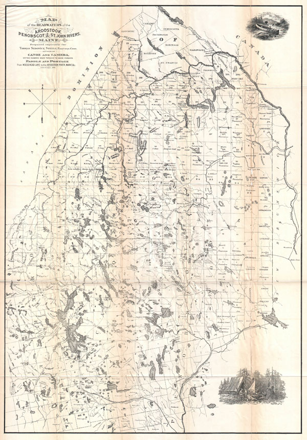

Title
Map of the Headwaters of the Aroostook, Penobscot & St. John Rivers, Maine.
1881 (dated) 28.5 x 20 in (72.39 x 50.8 cm)
1881 (dated) 28.5 x 20 in (72.39 x 50.8 cm)
Description
FOR THE ORIGINAL ANTIQUE MAP, WITH HISTORICAL ANALYSIS, CLICK HERE.
Digital Map Information
Geographicus maintains an archive of high-resolution rare map scans. We scan our maps at 300 DPI or higher, with newer images being 600 DPI, (either TIFF or JPEG, depending on when the scan was done) which is most cases in suitable for enlargement and printing.
Delivery
Once you purchase our digital scan service, you will receive a download link via email - usually within seconds. Digital orders are delivered as ZIP files, an industry standard file compression protocol that any computer should be able to unpack. Some of our files are very large, and can take some time to download. Most files are saved into your computer's 'Downloads' folder. All delivery is electronic. No physical product is shipped.
Credit and Scope of Use
You can use your digial image any way you want! Our digital images are unrestricted by copyright and can be used, modified, and published freely. The textual description that accompanies the original antique map is not included in the sale of digital images and remains protected by copyright. That said, we put significant care and effort into scanning and editing these maps, and we’d appreciate a credit when possible. Should you wish to credit us, please use the following credit line:
Courtesy of Geographicus Rare Antique Maps (https://www.geographicus.com).
How Large Can I Print?
In general, at 300 DPI, you should at least be able to double the size of the actual image, more so with our 600 DPI images. So, if the original was 10 x 12 inches, you can print at 20 x 24 inches, without quality loss. If your display requirements can accommodate some loss in image quality, you can make it even larger. That being said, no quality of scan will allow you to blow up at 10 x 12 inch map to wall size without significant quality loss. For more information, it is best consult a printer or reprographics specialist.
Refunds
If the high resolution image you ordered is unavailable, we will fully refund your purchase. Otherwise, digital images scans are a service, not a tangible product, and cannot be returned or refunded once the download link is used.
Cartographer
Thomas Sedgwick Steele (June 11, 1845 - September 9, 1903) was an American outdoorsman, writer, photographer and artist active in the latter half of the 19th century. Steele was born in Hartford Connecticut on June 11, 1845. As a young man he partnered with his father and established himself as a jeweler. While enjoying mild success in this profession, Steele's real passions were writing, painting, drawing. Steele published his first books, "Canoe and Camera" and "Paddle and Portage" in the early 1880s. These, like all of Steele's works were lavishly illustrated with engravings derived from his own paintings. They were also issued with a map of some historical importance as it represented one of the first maps ever created specifically with canoeists in mind. Steele formally gave up the jewelry business in 1887 to pursue his artistic passions. He went on to join the Boston Art Club, study in Paris with Marcius Sidmonds, and travel throughout Europe and North Africa. As an artist Steele developed a realist style and most of his work focused wildlife (specifically fish) and still life images of fruit. He is also known to have dabbled in impressionism and luminism, but neither style inspired him. Though he married twice, Steele fathered no known children. He died in Swampscott, MA on September 9th, 1903. More by this mapmaker...
Source
Steele, T. S., Canoe & Camera or Two Hundred Miles Through The Maine Forests, Illustrated.