Digital Image: 1930 Jaro Hess Map of the Land of Make Believe
MakeBelieve-hess-1930_d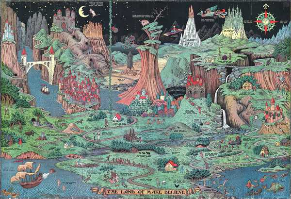

Title
The Land of Make Believe.
1930 (dated) 24.5 x 36 in (62.23 x 91.44 cm)
1930 (dated) 24.5 x 36 in (62.23 x 91.44 cm)
Description
FOR THE ORIGINAL ANTIQUE MAP, WITH HISTORICAL ANALYSIS, CLICK HERE.
Digital Map Information
Geographicus maintains an archive of high-resolution rare map scans. We scan our maps at 300 DPI or higher, with newer images being 600 DPI, (either TIFF or JPEG, depending on when the scan was done) which is most cases in suitable for enlargement and printing.
Delivery
Once you purchase our digital scan service, you will receive a download link via email - usually within seconds. Digital orders are delivered as ZIP files, an industry standard file compression protocol that any computer should be able to unpack. Some of our files are very large, and can take some time to download. Most files are saved into your computer's 'Downloads' folder. All delivery is electronic. No physical product is shipped.
Credit and Scope of Use
You can use your digial image any way you want! Our digital images are unrestricted by copyright and can be used, modified, and published freely. The textual description that accompanies the original antique map is not included in the sale of digital images and remains protected by copyright. That said, we put significant care and effort into scanning and editing these maps, and we’d appreciate a credit when possible. Should you wish to credit us, please use the following credit line:
Courtesy of Geographicus Rare Antique Maps (https://www.geographicus.com).
How Large Can I Print?
In general, at 300 DPI, you should at least be able to double the size of the actual image, more so with our 600 DPI images. So, if the original was 10 x 12 inches, you can print at 20 x 24 inches, without quality loss. If your display requirements can accommodate some loss in image quality, you can make it even larger. That being said, no quality of scan will allow you to blow up at 10 x 12 inch map to wall size without significant quality loss. For more information, it is best consult a printer or reprographics specialist.
Refunds
If the high resolution image you ordered is unavailable, we will fully refund your purchase. Otherwise, digital images scans are a service, not a tangible product, and cannot be returned or refunded once the download link is used.
Cartographer
Jaro Hess (March 22, 1889 - 1977), was a Czech painter and landscape designer. Hess was born in Prague, where he was named Jaroslav Hes. He immigrated to the United States in 1910, at the age of 21. Before immigrating, Hess received a degree in metallurgical engineering from the University of Prague, and soon thereafter joined the French Foreign Legion in Algiers. He quickly realized that this had been a poor decision and later remembered the experience as some of the ‘worst days of his life.’ After returning to Europe as a stowaway, he completed his military service in the Austrian army. After immigrating to America, Hess tried his luck in the Pittsburgh steel mills. He greatly disliked the ‘dirty city’ and left, embarking on a more circuitous and nomadic life, working as a chemist, engraver, horticulturist, and steelworker throughout the Midwest. Hess eventually ended up in Grand Rapids, Michigan, where he took over his father-in-law’s plant nursery. Over the course of the 1930s and 40s, Hess made a name for himself as an artist in the Grand Rapids artistic community, and drew his most famous work, The Land of Make Believe. Hess became known for his sketches of odd creatures and other supernatural themes. More by this mapmaker...
References
Rumsey 8153.000. OCLC 29319252.